The maps are listed in chronological order, regardless of their type and any series they may belong to. There are separate listings for the large-scale Ordnance Survy county series and national grid plans.
Hooker, John. Isca Damnoniorum: britanice Kaier penhuelgorte: Saxonice Monketon: Latine Exonia: Anglice Exancestre vel Excestre at nunc vulgo Exeter: urbs perantiqua, et emporium. ... opera et impensis ... Joannis Hokeri. - Opera et impensis Johanis Hokeri generosi ac huius civitatis quaestoris, hanc tabellam sculpsit Remigius Hogenbergius Anno Dei 1587. - State A. - [Exeter] : [ John Hooker], 1587. - Map : 350x512mm. - Scale bar [no scale given ca. 1:3,600]. - B&B: E001a. -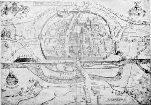
Copies: BL ; WSL: OM B/EXE/1587/HOO/A facsimile. -
Subjects: Devon. Exeter. Maps. 1587. -
Hooker, John. Isca Damnoniorum: britanice Kaier penhuelgorte: Saxonice Monketon: Latine Exonia: Anglice Exancestre vel Excestre at nunc vulgo Exeter: urbs perantiqua, et emporium. ... opera et impensis ... Joannis Hokeri. - Opera et impensis Johanis Hokeri generosi ac huius civitatis quaestoris, hanc tabellam sculpsit Remigius Hogenbergius Anno Dei 1587. - State B. - [Exeter] : [ John Hooker], 1587. - Map : 350x512mm. - Scale bar deleted [no scale given, ca. 1:3,600] - B&B: E001b. -
Copies: Dymond family of Chagford ; WSL: OM B/EXE/1587/HOO/B photograph. -
Subjects: Devon. Exeter. Maps. 1587. -
Hooker, John. Isca Damnoniorum: britanice Kaier penhuelgorte: Saxonice Monketon: Latine Exonia: Anglice Exancestre vel Excestre at nunc vulgo Exeter: urbs perantiqua, et emporium. ... opera et impensis ... Joannis Hokeri. - Opera et impensis Johanis Hokeri generosi ac huius civitatis quaestoris, hanc tabellam sculpsit Remigius Hogenbergius Anno Dei 1587. - State C. - [Exeter] : [ John Hooker?], 1587. Issued 1600? - Map : 350x512mm. - Scale bar deleted [no scale given, ca. 1:3,600] - B&B: E001c. -
Copies: DRO (Exeter Guildhall Collection). -
Subjects: Devon. Exeter. Maps. 1587. -
Hooker, John. Isca Damnoniorum: britanice Kaier penhuelgorte: Saxonice Monketon: Latine Exonia: Anglice Exancestre vel Excestre at nunc vulgo Exeter: urbs perantiqua, et emporium. ... opera et impensis ... Joannis Hokeri. - Opera et impensis Johanis Hokeri generosi ac huius civitatis quaestoris, hanc tabellam sculpsit Remigius Hogenbergius Anno Dei 1587. - State C. - [Exeter?] : [Samuel?], [ 1975?]. - Map ; 378x500mm. - State C: With compass rose. Facsimile. -
Copies: WSL: OM B/EXE/1587/HOO/C. -
Subjects: Devon. Exeter. Maps. 1587. -
Hooker, John [ Map of Cathedral Close, Exeter]. - Exeter : William Pollard & Co., [ 1919). Map : 236x306mm. - Facsimile of manuscript map of ca.1590. From DCRS publication?. -
Copies: WSL: B/EXE/1590/HOO. -
Subjects: Devon. Exeter. Maps. 1590. -
Hooker, John [ St. Sidwell's fee] / William Pollard & Co. Ltd, lithographers. - [Exeter] : [Devon & Cornwall Record Soc.], [ 1919. - Map ; 231x286mm. - From: Hooker, John. The description of the citie of Excester. -
Copies: WSL: MM B/EXE/1600/HOO. -
Subjects: Devon. Exeter. Maps. 1590. -
Speed, John. Excester. - Performed by Ihon Speede [London] : and are to be sold in Popes-head Alleye by Iohn Sudbui & George Humble, [ 1610]. - Map : 132x155mm. Scale [none ca. 1:12,500]. - B&B: E002. -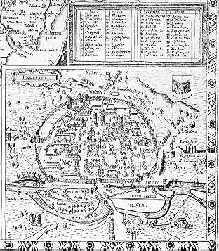
Braun, Georg Civitas Exoniae 1587. - Exeter : Townsend lith , [ 1618. Issued [1873]. - Map ; 198x386mm. - Redrawn for Cotton,W. An Elizabethan guild of the city of Exeter. -
Copies: WSL: MM B/EXE/1618/BRA. -
Subjects: Devon. Exeter. Maps. 1618. -
Braun, Georg Civitas Exoniae (vulgo Excester) urbs primaria .... - [Exeter] : [Commins], [ 1618. Issued [1895?]). - Map ; 265x320mm. - Facsimile with title: Exeter in 1618. Advertisements on verso. -
Copies: WSL: LM B/EXE/1618/BRA. -
Subjects: Devon. Exeter. Maps. 1618. -
Braun, Georg Civitas Exoniae (vulgo Excester) urbs primaria .... - Exeter : J.G.Commin, [ 1618. Issued [1895?]. - Map ; 315x402mm. - Facsimile with title: Exeter, A.D. 1570. -
Copies: WSL: OM B/EXE/1618/BRA. -
Subjects: Devon. Exeter. Maps. 1618. -
Braun, Georg Civitas Exoniae (vulgo Excester) urbs primaria .... - [s.l.] : [s.n.] , [ 1618. Issued 1660]. - Map ; 315x402mm. - Reissue in: Illustriorum principiumque urbium ... 1660. -
Copies: WSL: OM B/EXE/1618/BRA. -
Subjects: Devon. Exeter. Maps. 1618. -
Braun, Georg [ Civitas Exoniae]. - [s.l.] : [s.n.] , [ 1618. Issued 1800?]). - Map ; 215x282mm. - B&B: 052.2. - Unidentified re-engraving of Braun's plan of 1618. -
Copies: WSL: MM B/EXE/1618/1800. -
Subjects: Devon. Exeter. Maps. 1618. -
Braun, Georg Civitas Exoniae (vulgo Excester) urbs primaria ... / Mutlow sc. - [London?] : [s.n.] , [ 1822]. - Map ; 210x263mm. - Engraved for Lysons, D. Magna Britannia. -
Copies: WSL: MM B/EXE/1618/BRA. -
Subjects: Devon. Exeter. Maps. 1618. -
Braun, Georg. Civitas Exoniae (vulgo Excester) urbs primaria in comitatu Devoniae. - [Georg Braun ; Frans Hogenberg]. - Braun, Georg. 1618]. - Map : 317x395mm. Scale [none]. - B&B: E003. -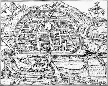
Copies: WSL: OM B/EXE/1618/BRA.
Subjects: Devon. Exeter. Maps. 1618. -
Meisner, Daniel. Excester in Engellandt. - [s.l.] : [s.n.], [ 1700]. - Map ; 96x141mm. - From: Libellus novus politicus emblematicus civitatum 1700. -
Copies: WSL: SM B/EXE/1700/MEI. -
Subjects: Devon. Exeter. Maps. 1631. -
Meisner, Daniel. Excester in Engellandt. - Daniel Meisner. - [Nurnberg] : [ Paulus Fürst], [ 1631]. - Map: 95x140mm Scale [none]. - B&B: E004. - In: Libellus novus politicus emblematicus civitatum, vol. 7. Reissued 1638 and 1700. The printed maps of Exeter / Francis Bennett ; Kit Batten (2011) ; 4. -
Copies: WSL: SM B/EXE/1700/MEI.
Subjects: Devon. Exeter. Maps. 1631. -
Merian, Matthias. Exonia, Excester. - [s.l.] : [s.n.], [ 1650]. - Map ; 158x128mm. - From a series of 17 plans of British Towns without letterpress. -
Copies: WSL: SM B/EXE/1650/MER. -
Subjects: Devon. Exeter. Maps. 1650. -
Merian, Matthias. Exonia, Excester. - [Mathias Merian]. - [Frankfurt] : [ s. n.] , [ 1650]. - Map : 160x130mm. Scale [none]. - B&B: E005. -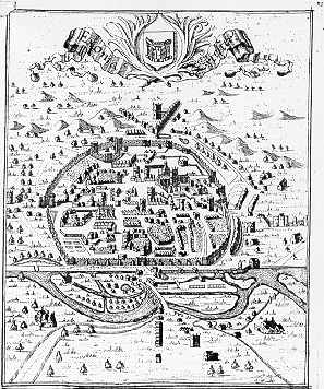
Copies: WSL: SM B/EXE/1650/MER.
Subjects: Devon. Exeter. Maps. 1650. -
Hermannides, Rutgerus. Exonia. Excester. - [Rutgerus Hermannides]. - [Amsterdam] : [ s. n.] , [ 1661]. - Map : 105x130mm Scale [none]. - B&B: E006. -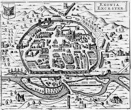
Copies: WSL: MM B/EXE/1661/HER.
Subjects: Devon. Exeter. Maps. 1661. -
Izacke, Richard. A mapp of the city of Exeter. - [Richard Izacke]. - [London] : [ Richard Marriott], [ 1677]. - Map : 160x193mm. Scale [none]. - B&B: E007. -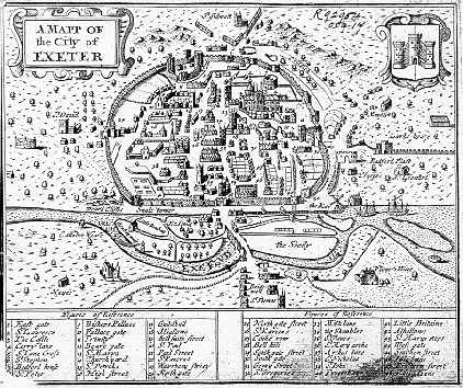
Copies: WSL: MM B/EXE/1677/IZA.
Subjects: Devon. Exeter. Maps. 1677. -
Lamb, Francis. Excester. - London : Philip Lea, 1689. - Map : 132x155mm. Scale [none ca. 1:12,500]. - B&B: 019. -
Copies: WSL. -
Subjects: Devon. Exeter. Maps. 1677. -
Fairlove, Ichabod, A true plan of the city of Excester Anno Domini MDCCIX. Ichd: Fairlove surveyd Io: Coles sculp: - [ Exeter] : Sold by Edward Score bookseller over agst: the Guildhall, [ 1709]. - Map : 545x450mm. Scale bar: A scale of 100 feet [= 102mm] 1:2880. - B&B: E008. -
Copies: WSL: OM B/EXE/1709/COL ; DRO
Subjects: Devon. Exeter. Maps. 1709. -
Engraver: Coles, John.
Stukeley, William. Isca Dumnoniorum 19 Aug 1723. - Stukeley delin. ; Parker sculp. - 1723. - Map : 273x170mm. Scale bar: A scale of 1000 feet = 31mm 1:6240. - B&B: E010. -
Copies: WSL: LM B/EXE/1723/STU.
Subjects: Devon. Exeter. Maps. 1723. -
Nicholls, Sutton. A true plan of the city of Excester. - drawn & engraven by Sutton Nichols. - [London] : [ Samuel Birt and sold by Edward Score, John March and Nathenial Thorne in Exeter], [ 1723]. - Map: 254x162mm. Scale bar: A scale of 1000 feet = 54mm 1:5760. - B&B: E009. -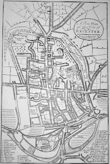
Copies: WSL: MM B/EXE/1723/NIC photocopy.
Subjects: Devon. Exeter. Maps. 1723. -
Chapple, William, 1718–1781. - A plan of the Devon and Exeter Hospital at Exon. - [Exeter] : Engraved in 1741. - 1 plan. - DRO: 2610M/F3. - Exeter. Hospitals. Devon and Exeter Hospital. Plans. 1741. -
Birchynshaw, William. A platforme of the city of Exon 1743 / William Birchynshaw [fecit]. - [Exeter] : William Birchynshaw, 1743. - Map ; 383 x 321 mm. Scale ca. 1:3,600 [1 inch = 100 yards]. -
Copies: Private collection.
Subjects: Devon. Exeter. Maps. 1743. -
Rocque, John. Plan de la ville et faubourgs d'Exeter / tres exactement leve & desseinne par I.Roque ; R. White sculp. - 1744. - Map (2 sheets) : 745x1165mm. Scale bars: 5, including 1M = 660mm, 1:2,400]. - B&B: E011. -
Copies: WSL: LM B/EXE/1744/ROC.
Subjects: Devon. Exeter. Maps. 1744. -
Chapple, William, 1718–1781. - A Plan of the Ground belonging to the Devon and Exeter Hospital. - Exeter] : [Manuscript, dated] June 8 1744. - 1 plan. - DRO: 2610M/F3. - Exeter. Hospitals. Devon and Exeter Hospital. Estates. Plans. 1744. -
Chapple, William, 1718–1781. A Map of so much of Higher Broomham, or Reynolds's Tenement, (the Lands of Sir William Courtenay Bart) as shews the Ancient and present Way from thence thro' the Lands of Mr Coffin to Alpington church etc. [Manuscript] : Taken 1748. - 1 plan. - Rowe and Ravehill 1/4/1. - DRO: 1508M Devon/M&P/Alphington A2. - Exeter. Manors. Alphington. Maps. 1748. -
Chapple, William, 1718–1781. A General Map shewing all the publick Roads that lead to the Barn Close […] part of Higher Broomham or Reynolds's Tenement in ye Manor of Alphington (the Lands of Sir William Courtenay Bart) […]. 1749. - Map. - Rowe and Ravehill 1/4/2. - DRO: 1508M Devon/M&P/Alphington A14. - Exeter. Manors. Alphington. Maps. 1749. -
Chapple, William, 1718–1781. [Untitled map showing Bliss's tenement and Vinnicombe's tenement, Alphington]. - [Manuscript], [ 1750?]. - Map. - Rowe and Ravehill 1/4/4. - DRO: 1508M Devon/M&P/Alphington A10. - Exeter. Manors. Alphington. Maps. 1750?. -
Chapple, William, 1718–1781. [Untitled map of Alphington made as the result of a view to ascertain the "Claims of the Landscores belonging to each Tenement"], [Manuscript], 1761. - Map. - Rowe and Ravehill 1/4/10. - DRO: 1508M Devon/M&P/Alphington/Maps 5. - Exeter. Manors. Alphington. Maps. 1761. -
Rocque, John. Plan of the city of Exeter. - [by the late Mr. J. Rocque]. - [London] : Andrew Drury, [ 1761]. - Map ; 98x101mm. - Scale bar 36 mm = 1/2 a mile. - B&B: E012. -
Copies: WSL: SM B/EXE/1761/ROC.
Subjects: Devon. Exeter. Maps. 1761?. -
Rocque, John. Plan of the city of Exeter, reduc'd from the large survey in two sheets by the late John Rocque, topographer to His Majesty ; P.Andrews sculp. - [London] : Mary Anne Rocque, 1764. - Map ; 290x480mm. Scale 1:4800 B&B: E013. -
Copies: WSL: OM B/EXE/1761/ROC.
Subjects: Devon. Exeter. Maps. 1764. -
Donn, Benjamin. Plan of the city and suburbs of Exeter. - Benjamin Donn. - London : Printed for the author and sold by the booksellers of Devon, by Mr Johnston in Ludgate Street, Mr Baldwin in Paternoster Row ; and the print-sellers of London, MDCCLXV, [ 1765]. - Map : 404x470mm. Scale bar One mile = 328mm]. - B&B: E014. -
Copies: WSL: PM B/EXE/1765/DON : OM B/EXE/1765/DON.
Subjects: Devon. Exeter. Maps. 1765. -
Chapple, William, 1718–1781. [ Exeter]. - [Exeter] : [Manuscript], [ 1775?]. - 255 x 230 mm ; scale: approximately 1:7350. - Untitled map, executed in pen and ink with some pencil annotations and the open spaces behind the street frontages in sepia. It was sketched diagonally on a sheet of paper with a J Whatman watermark. DRO: 2610M/F3/folio 96. - Exeter. Maps. 1775?. -
Chapple, William, 1718–1781. [ Exeter]. - [Exeter] : [Manuscript], [ 1775?]. - 230 x 185 mm ; scale approximately 1:17850. - Untitled map, executed in pen and ink with a small paste-on in the centre with the edges marked by pencilled crosses. There is no watermark. DRO: 2610M/F3/folio 97. - Exeter. Maps. 1775?. -
Chapple, William, 1718–1781. A map or plan of the city of Exeter [pencilled]. - [Exeter] : [Engraved], [ 1775?]. - 249 x 221 mm in size ; scale approximately 1:7500. - Working proof of a map engraved on a copperplate 280 x 250 mm. Annotations in pencil and ink and a space is left blank, probably awaiting the text of a key to major streets and buildings. There is no watermark. DRO: 2610M/F3/folio 98. - Exeter. Maps. 1775?. -
Tozer, Charles. Plan of the city and suburbs of Exeter. - [Exeter] : Publish'd by C. Tozer April 20th 1792. - Map ; 345x410mm. - Scale bar 83 mm = 80 poles. - B&B: E015. -
Copies: WSL: OM B/EXE/1793/TOZ.
Subjects: Devon. Exeter. Maps. 1792. -
Britton, J. Exeter / engraved by J.Roper from ... I.Hayman ... to accompany the Beauties of England and Wales. - London : Vernor and Hood, 1805. - Map ; 235x180mm. - Scale bar 24 mm = 800 feet. - B&B: E016. -
Copies: WSL: MM B/EXE/1805/BRI. -
Subjects: Devon. Exeter. Maps. 1805. -
Hayman, John. Exeter. - Engraved by B. Baker & D. Wright, Islington ; From a survey & drawing by J. Hayman. - Exeter : Engraved for Alexr. Jenkins History of Exeter and published by P. Hedgeland, High Street, Exeter, April 19, 1806. - Map ; 205x235 mm ; scale bar: Quarter of a mile 20 chains = 26 mm. - B&B: E017. -
Subjects: Devon. Exeter. Maps. 1806. -
A plan of Rougemont Castle as decribed by Leland in the 16th century. - Exeter : [Engraved for Alexr. Jenkins History of Exeter and published by P. Hedgeland, High Street, Exeter, April 19, 1806]. - Map ; 157x104 mm ; Scale of yards 50 = 23 mm. - B&B: E018. -
Subjects: Devon. Exeter. Castles. Rougemot Castle. Plans. 1540. -
Smith, C. Map of the roads round Exeter including the Exeter Turnpike Trust. - London : for C.Smith, [ 1825?]. - Map ; 312x362mm. - Scale bar 141 mm = 1+10 miles. -
Copies: WSL: MM B/EXE/1825/SMI. -
Subjects: Devon. Exeter. Maps. 1825. -
Besley. Exeter in 1828 : to accompany the Exeter itinerary and general directory. - [Exeter] : [Besley], 1828. - Map ; 232x213mm. - Scale bar 25 mm = 800 feet. - B&B: E020. -
Copies: WSL: MM B/EXE/1828/BES. -
Subjects: Devon. Exeter. Maps. 1828. -
Hackett. [ Exeter]. - Exeter : Hackett lithog, [ 1830?]. - Map ; 380x297mm. - Scale bar 65 mm = 1+15 chains. - Shows proposed Barnfield and New North Roads. -
Copies: WSL: LM B/EXE/1830/HAC. -
Subjects: Devon. Exeter. Maps. 1830. -
Dawson, Robert K. Exeter from the Ordnance Survey. - [London] : [HMSO], [ 1832]. - Map ; 247x155mm. - Scale 2 inches to a mile. - B&B: E024. - From Reports from Commissioners on proposed division of counties. -
Copies: WSL: LM B/EXE/1832/DAW. -
Subjects: Devon. Exeter. Maps. 1832. -
Brown, R. The city of Exeter 1835. / Drawn by R.Brown ; engraved by W.Schmollinger. - Exeter : R.Colliver, 1835. - Map ; 202x243mm. - Scale bar 35 mm = 1000 feet. - B&B: E026. -
Copies: WSL: MM B/EXE/1835/BRO. -
Subjects: Devon. Exeter. Maps. 1835. -
Creighton, R. EXETER. TAVISTOCK. Drawn by R.Creighton. Engraved by J&C; Walker. - [London] : [S.Lewis & Co.], [ 1835]. - Map ; 181x 236cm. - B&B: 113.1. - In: View of the representative history of England. Plate 20. -
Copies: WSL: BB LM DEV/1835/CRE. -
Subjects: Devon. Exeter. Maps. 1835. -
Dawson, Robert K. Exeter : from the Ordnance Survey. - Scale 4 inches to 1 mile. - [London] : [HMSO], [ 1837]. - Map ; 320x175mm. - From: Reports from Commissioners on municipal corporation boundaries. -
Copies: WSL: LM B/EXE/1837/DAW. -
Subjects: Devon. Exeter. Maps. 1837. -
Wood, John. A plan of Exeter from actual survey / John Wood surveyor, 34 Paul. - [Exeter] : [Improvement Comm?], 1840. - Map ; 675x805mm. -
Copies: WSL: DRO ; DEI. -
Subjects: Devon. Exeter. Maps. 1840. -
Shapter, Thomas. Plans and sections of the city and suburbs of Exeter ... - [London] : [Clowes], 1845. - Map ; 295x477mm. - From: Report on the sanatory condition of Exeter. Shows sewerage. -
Copies: WSL: OM B/EXE/1845/SHA. -
Subjects: Devon. Exeter. Maps. 1845. -
Norden, John Fac-simile plan of the Castle Precinct Exeter / made by Norden. - Exeter : George G.Palmer lith , [ 1850?]. - Map ; 150x190mm. - Copy of 1617 map in BL Add. ms. 6027 fo.80b-81a. Photograph. -
Copies: WSL: SM B/EXE/1617/NOR. -
Subjects: Devon. Exeter. Maps. 1617. -
Warren, J. Exeter, corrected to the present time / by J.Warren, surveyor ; engraved by ... F.P.Becker & Co. - Scale bar 40 mm = 30 chains. - Exeter : Henry Besley, [ 1845?]. - Map ; 235x283mm. - B&B: E031. -
Copies: WSL: LM B/EXE/1850/WAR. -
Subjects: Devon. Exeter. Maps. 1845. -
Featherstone & Co. Map of the city of Exeter, embracing all the alterations and improvements to the present period. - Exeter : Featherstone & Co., [ 1852?]. - Map ; 445x595mm. - Scale bar 75mm:1+20 chains. -
Copies: WSL: PM B/EXE/1852/FEA. -
Subjects: Devon. Exeter. Maps. 1852. -
Tallis, John. Exeter / the illustrations drawn & engraved by H.Winkles ; the plan drawn and engraved by J.Rapkin. - London : John Tallis & Company, [ 1852?]. - Map ; 265x330mm. -
Copies: WSL: LM B/EXE/1852/TAL. -
Subjects: Devon. Exeter. Maps. 1852. -
Tallis, John Exeter / illustrations ... by H.Winkles ; plan ... by J.Rapkin. - London : Whitehall Press, [ 1852]. Issued [1985?]). Map : 380x460mm. -
Copies: WSL: OM B/EXE/1852/TAL. -
Subjects: Devon. Exeter. Maps. 1852. -
Featherstone. Map of Exeter. - Exeter : Featherstone, [ 1855?]. - Map ; 185x233mm. - Scale bar 36 mm = 1,000 feet. - Shows line of intended Exeter and Yeovil Railway. -
Copies: WSL: MM B/EXE/1855/FEA. -
Subjects: Devon. Exeter. Maps. 1855. -
James, Henry. Exeter / Henry James. - Southampton : Ordnance Survey, 1868. - Map ; 330x220mm. Scale bar 90 mm = 1000+5280 feet. - From: Parliamentary boundary commissioners report. -
Copies: WSL: LM B/EXE/1868/JAM with text. -
Subjects: Devon. Exeter. Maps. 1868. -
Besley, Henry. Exeter, corrected to the present time. - Besley, Henry. 1870?]. -
Copies: WSL: p B/EXE/912/1870.
Subjects: Devon. Exeter. Maps. 1870. -
Besley, Henry. Exeter. - Exeter : Henry Besley, [ 1881]. - Map ; 235x285mm. - Scale bar42 mm = 5+15 chains. - From: Besley's Exeter directory 1881. -
Copies: WSL: LM B/EXE/1881/BES. -
Subjects: Devon. Exeter. Maps. 1881. -
Vincent, A. Ground plan of Exeter. - 1884. -
Copies: WSL: sB/EXE/1884/VIN.
Subjects: Devon. Exeter. Maps. 1884. -
Braun, Georg. Civitas Exoniae (vulgo Excester) urbs primaria ... - 1886. -
Copies: WSL: OM B/EXE/1618/BRA.
Subjects: Devon. Exeter. Maps. 1886. -
Goad, Charles E. Insurance Plan of Exeter: Key Plan. - London: Charles E. Goad, 1888. - Map : coloured ; scale 1 inch to 40 feet (1:480). - BL image accessed February 2020. -
Copies: BL ; WSL. -
Subjects: Devon. Exeter. Insurance. Plans. 1888. -
Goad, Charles E. Insurance Plan of Exeter: sheet 2-1. - London: Charles E. Goad, 1888. - Map : coloured ; scale 1 inch to 40 feet (1:480). - BL image accessed February 2020. -
Copies: BL ; WSL. -
Subjects: Devon. Exeter. Insurance. Plans. 1888. -
Goad, Charles E. Insurance Plan of Exeter: sheet 2-2. - London: Charles E. Goad, 1888. - Map : coloured ; scale 1 inch to 40 feet (1:480). - BL image accessed February 2020. -
Copies: BL ; WSL. -
Subjects: Devon. Exeter. Insurance. Plans. 1888. -
Goad, Charles E. Insurance Plan of Exeter: sheet 3. - London: Charles E. Goad, 1888. - Map : coloured ; scale 1 inch to 40 feet (1:480). - BL image accessed February 2020. -
Copies: BL ; WSL. -
Subjects: Devon. Exeter. Insurance. Plans. 1888. -
Goad, Charles E. Insurance Plan of Exeter: sheet 4-1. - London: Charles E. Goad, 1888. - Map : coloured ; scale 1 inch to 40 feet (1:480). - BL image accessed February 2020. -
Copies: BL ; WSL. -
Subjects: Devon. Exeter. Insurance. Plans. 1888. -
Goad, Charles E. Insurance Plan of Exeter: sheet 4-2. - London: Charles E. Goad, 1888. - Map : coloured ; scale 1 inch to 40 feet (1:480). -
Copies: BL ; WSL. -
Subjects: Devon. Exeter. Insurance. Plans. 1888. -
Goad, Charles E. Insurance Plan of Exeter: sheet 5. - London: Charles E. Goad, 1888. - Map : coloured ; scale 1 inch to 40 feet (1:480). -
Copies: BL ; WSL. -
Subjects: Devon. Exeter. Insurance. Plans. 1888. -
Goad, Charles E. Insurance Plan of Exeter: sheet 6. - London: Charles E. Goad, 1888. - Map : coloured ; scale 1 inch to 40 feet (1:480). -
Copies: BL ; WSL. -
Subjects: Devon. Exeter. Insurance. Plans. 1888. -
Goad, Charles E. Insurance Plan of Exeter: sheet 7-1. - London: Charles E. Goad, 1888. - Map : coloured ; scale 1 inch to 40 feet (1:480). -
Copies: BL ; WSL. -
Subjects: Devon. Exeter. Insurance. Plans. 1888. -
Goad, Charles E. Insurance Plan of Exeter: sheet 7-2. - London: Charles E. Goad, 1888. - Map : coloured ; scale 1 inch to 40 feet (1:480). -
Copies: BL ; WSL. -
Subjects: Devon. Exeter. Insurance. Plans. 1888. -
Goad, Charles E. Insurance Plan of Exeter: sheet 7-3. - London: Charles E. Goad, 1888. - Map : coloured ; scale 1 inch to 40 feet (1:480). -
Copies: BL ; WSL. -
Subjects: Devon. Exeter. Insurance. Plans. 1888. -
Goad, Charles E. Insurance Plan of Exeter: sheet 7-4. - London: Charles E. Goad, 1888. - Map : coloured ; scale 1 inch to 40 feet (1:480). -
Copies: BL ; WSL. -
Subjects: Devon. Exeter. Insurance. Plans. 1888. -
Goad, Charles E. Insurance Plan of Exeter: sheet 8. - London: Charles E. Goad, 1888. - Map : coloured ; scale 1 inch to 40 feet (1:480). -
Copies: BL ; WSL. -
Subjects: Devon. Exeter. Insurance. Plans. 1888. -
Goad, Charles E. Insurance plan of Exeter. - Sheet 1. - London: Charles E. Goad, 1888. - Map : coloured ; scale 1 inch to 40 feet (1:480). - Revisions: None. - Flap down
Copies: WSL: Goad aperture card ; 1. - Devon. Exeter. Insurance. Plans. 1888. -
Goad, Charles E. Insurance plan of Exeter. - Sheet 3. - London: Charles E. Goad, 1888. - Map : coloured ; scale 1 inch to 40 feet (1:480). - Revisions: None. -
Copies: WSL: Goad aperture card ; 5. - Devon. Exeter. Insurance. Plans. 1888. -
Goad, Charles E. Insurance plan of Exeter. - Sheet 4. - London: Charles E. Goad, 1888. - Map : coloured ; scale 1 inch to 40 feet (1:480). - Revisions: None. -
Copies: WSL: Goad aperture card ; 7. - Devon. Exeter. Insurance. Plans. 1888. -
Goad, Charles E. Insurance plan of Exeter. - Sheet 1. - London: Charles E. Goad, 1888. - Map : coloured ; scale 1 inch to 40 feet (1:480). - Revised to 1911. -
Copies: WSL: Goad aperture card ; 14. - Devon. Exeter. Insurance. Plans. 1911. -
Goad, Charles E. Insurance plan of Exeter. - Sheet 2. - London: Charles E. Goad, 1888. - Map : coloured ; scale 1 inch to 40 feet (1:480). - Revised to 1911. -
Copies: WSL: Goad aperture card ; 15. - Devon. Exeter. Insurance. Plans. 1911. -
Goad, Charles E. Insurance plan of Exeter. - Sheet 2. - London: Charles E. Goad, 1888. - Map : coloured ; scale 1 inch to 40 feet (1:480). - Revised to 1911. -
Copies: WSL: Goad aperture card ; 16. - Devon. Exeter. Insurance. Plans. 1911. -
Goad, Charles E. Insurance plan of Exeter. - Sheet 2. - Outline. - London: Charles E. Goad, 1888. - Map ; scale 1 inch to 40 feet (1:480). - Revised to 1911. - Flap down
Copies: WSL: Goad aperture card ; 17. - Devon. Exeter. Insurance. Plans. 1911. -
Goad, Charles E. Insurance plan of Exeter. - Sheet 2. - Outline. - London: Charles E. Goad, 1888. - Map ; scale 1 inch to 40 feet (1:480). - Revised to 1911. - Flap raised
Copies: WSL: Goad aperture card ; 18. - Devon. Exeter. Insurance. Plans. 1911. -
Goad, Charles E. Insurance plan of Exeter. - Sheet 3. - London: Charles E. Goad, 1888. - Map : coloured ; scale 1 inch to 40 feet (1:480). - Revised to 1911. -
Copies: WSL: Goad aperture card ; 19. - Devon. Exeter. Insurance. Plans. 1911. -
Goad, Charles E. Insurance plan of Exeter. - Sheet 3. - Outline. - London: Charles E. Goad, 1888. - Map ; scale 1 inch to 40 feet (1:480). - Revised to 1911. -
Copies: WSL: Goad aperture card ; 20. - Devon. Exeter. Insurance. Plans. 1911. -
Goad, Charles E. Insurance plan of Exeter. - Sheet 4. - London: Charles E. Goad, 1888. - Map : coloured ; scale 1 inch to 40 feet (1:480). - Revised to 1911. -
Copies: WSL: Goad aperture card ; 21. - Devon. Exeter. Insurance. Plans. 1911. -
Goad, Charles E. Insurance plan of Exeter. - Sheet 4. - Outline. - London: Charles E. Goad, 1888. - Map ; scale 1 inch to 40 feet (1:480). - Revised to 1911. -
Copies: WSL: Goad aperture card ; 22. - Devon. Exeter. Insurance. Plans. 1911. -
Goad, Charles E. Insurance plan of Exeter. - Sheet 1. - London: Charles E. Goad, 1888. - Map : coloured ; scale 1 inch to 40 feet (1:480). - Revised to 1921. -
Copies: WSL: Goad aperture card ; 23. - Devon. Exeter. Insurance. Plans. 1921. -
Goad, Charles E. Insurance plan of Exeter. - Sheet 2. - London: Charles E. Goad, 1888. - Map : coloured ; scale 1 inch to 40 feet (1:480). - Revised to 1921. -
Copies: WSL: Goad aperture card ; 24. - Devon. Exeter. Insurance. Plans. 1921. -
Goad, Charles E. Insurance plan of Exeter. - Sheet 2. - London: Charles E. Goad, 1888. - Map : coloured ; scale 1 inch to 40 feet (1:480). - Revised to 1921. -
Copies: WSL: Goad aperture card ; 25. - Devon. Exeter. Insurance. Plans. 1921. -
Goad, Charles E. Insurance plan of Exeter. - Sheet 2. - Outline. - London: Charles E. Goad, 1888. - Map ; scale 1 inch to 40 feet (1:480). - Revised to 1921. - Flap down
Copies: WSL: Goad aperture card ; 26. - Devon. Exeter. Insurance. Plans. 1921. -
Goad, Charles E. Insurance plan of Exeter. - Sheet 2. - Outline. - London: Charles E. Goad, 1888. - Map ; scale 1 inch to 40 feet (1:480). - Revised to 1921. - Flap raised
Copies: WSL: Goad aperture card ; 27. - Devon. Exeter. Insurance. Plans. 1921. -
Goad, Charles E. Insurance plan of Exeter. - Sheet 3. - London: Charles E. Goad, 1888. - Map : coloured ; scale 1 inch to 40 feet (1:480). - Revised to 1921. -
Copies: WSL: Goad aperture card ; 28. - Devon. Exeter. Insurance. Plans. 1921. -
Goad, Charles E. Insurance plan of Exeter. - Sheet 3. - Outline. - London: Charles E. Goad, 1888. - Map ; scale 1 inch to 40 feet (1:480). - Revised to 1921. -
Copies: WSL: Goad aperture card ; 29. - Devon. Exeter. Insurance. Plans. 1921. -
Goad, Charles E. Insurance plan of Exeter. - Sheet 4. - London: Charles E. Goad, 1888. - Map : coloured ; scale 1 inch to 40 feet (1:480). - Revised to 1921. - Flap raised
Copies: WSL: Goad aperture card ; 30. - Devon. Exeter. Insurance. Plans. 1921. -
Goad, Charles E. Insurance plan of Exeter. - Sheet 4. - London: Charles E. Goad, 1888. - Map : coloured ; scale 1 inch to 40 feet (1:480). - Revised to 1921. - Flap down
Copies: WSL: Goad aperture card ; 31. - Devon. Exeter. Insurance. Plans. 1921. -
Goad, Charles E. Insurance plan of Exeter. - Sheet 4. - Outline. - London: Charles E. Goad, 1888. - Map ; scale 1 inch to 40 feet (1:480). - Revised to 1921. -
Copies: WSL: Goad aperture card ; 32. - Devon. Exeter. Insurance. Plans. 1921. -
Goad, Charles E. Insurance plan of Exeter. - Sheet 2. - London: Charles E. Goad, 1888. - Map : coloured ; scale 1 inch to 40 feet (1:480). - Revised to 1945. - Flap down Obsolete
Copies: WSL: Goad aperture card ; 42. - Devon. Exeter. Insurance. Plans. 1945. -
Goad, Charles E. Insurance plan of Exeter. - Sheet 2. - London: Charles E. Goad, 1888. - Map : coloured ; scale 1 inch to 40 feet (1:480). - Revised to 1945. - Flap raised Obsolete
Copies: WSL: Goad aperture card ; 43. - Devon. Exeter. Insurance. Plans. 1945. -
Goad, Charles E. Insurance plan of Exeter. - Sheet 4. - Outline. - London: Charles E. Goad, 1888. - Map ; scale 1 inch to 40 feet (1:480). - Revised to 1945. - Obsolete
Copies: WSL: Goad aperture card ; 52. - Devon. Exeter. Insurance. Plans. 1945. -
Goad, Charles E. Insurance plan of Exeter. - Sheet 2. - London: Charles E. Goad, 1888. - Map : coloured ; scale 1 inch to 40 feet (1:480). - Revised to 1959. - Flap down
Copies: WSL: Goad aperture card ; 68. - Devon. Exeter. Insurance. Plans. 1959. -
Goad, Charles E. Insurance plan of Exeter. - Sheet 2. - London: Charles E. Goad, 1888. - Map : coloured ; scale 1 inch to 40 feet (1:480). - Revised to 1959. - Flap raised
Copies: WSL: Goad aperture card ; 69. - Devon. Exeter. Insurance. Plans. 1959. -
Goad, Charles E. Insurance plan of Exeter. - Sheet 2. - London: Charles E. Goad, 1888. - Map : coloured ; scale 1 inch to 40 feet (1:480). - Revised to 1962. - Flap down
Copies: WSL: Goad aperture card ; 90. - Devon. Exeter. Insurance. Plans. 1962. -
Goad, Charles E. Insurance plan of Exeter. - Sheet 2. - London: Charles E. Goad, 1888. - Map : coloured ; scale 1 inch to 40 feet (1:480). - Revised to 1962. - Flap raised
Copies: WSL: Goad aperture card ; 91. - Devon. Exeter. Insurance. Plans. 1962. -
Wheaton, A. Wheaton's new map of Exeter and neighbourhood including Exmouth, ... From the new Ordnance Survey. - London : G.W.Bacon & Co., [ 1890?]. - Map ; 485x560. - Scale bar 38 mm = 2 miles. -
Copies: WSL: FM B/EXE/1890/WHE. -
Subjects: Devon. Exeter. Maps. 1890. -
Wheaton, A. Wheaton's new map of Exeter and neighbourhood including Exmouth, ... From the new Ordnance Survey. - Exeter : A.Wheaton & Co., [ 1895?]. - Map ; 485x560. - Scale bar 38 mm = 2 miles. -
Copies: WSL: FM B/EXE/1895/WHE. -
Subjects: Devon. Exeter. Maps. 1895. -
Philip, George & Son. Plan of Exeter. - 1898. -
Copies: sB EXE/1898/NEW.
Subjects: Devon. Exeter. Maps. 1898. -
Bacon, G.W. & Co. Bacon's plan of Exeter and suburbs. - Bacon, G.W. & Co. 1900?].
Copies: WSL: p B/EXE/912/1900. .
Subjects: Devon. Exeter. Maps. 1900. -
Goad, Charles E. Insurance plan of Exeter. - Sheet 7. - London: Charles E. Goad, 1902. - Map : coloured ; scale 1 inch to 40 feet (1:480). - Revisions: None. -
Copies: WSL: Goad aperture card ; 11. - Devon. Exeter. Insurance. Plans. 1902. -
Goad, Charles E. Insurance plan of Exeter. - Sheet 5. - London: Charles E. Goad, 1902. - Map : coloured ; scale 1 inch to 40 feet (1:480). - Revised to 1921. -
Copies: WSL: Goad aperture card ; 33. - Devon. Exeter. Insurance. Plans. 1921. -
Goad, Charles E. Insurance plan of Exeter. - Sheet 5. - Outline. - London: Charles E. Goad, 1902. - Map ; scale 1 inch to 40 feet (1:480). - Revised to 1921. -
Copies: WSL: Goad aperture card ; 34. - Devon. Exeter. Insurance. Plans. 1921. -
Goad, Charles E. Insurance plan of Exeter. - Sheet 6. - London: Charles E. Goad, 1902. - Map : coloured ; scale 1 inch to 40 feet (1:480). - Revised to 1921. -
Copies: WSL: Goad aperture card ; 35. - Devon. Exeter. Insurance. Plans. 1921. -
Goad, Charles E. Insurance plan of Exeter. - Sheet 6. - Outline. - London: Charles E. Goad, 1902. - Map ; scale 1 inch to 40 feet (1:480). - Revised to 1921. -
Copies: WSL: Goad aperture card ; 36. - Devon. Exeter. Insurance. Plans. 1921. -
Goad, Charles E. Insurance plan of Exeter. - Sheet 7. - London: Charles E. Goad, 1902. - Map : coloured ; scale 1 inch to 40 feet (1:480). - Revised to 1921. -
Copies: WSL: Goad aperture card ; 37. - Devon. Exeter. Insurance. Plans. 1921. -
Goad, Charles E. Insurance plan of Exeter. - Sheet 7. - Outline. - London: Charles E. Goad, 1902. - Map ; scale 1 inch to 40 feet (1:480). - Revised to 1921. -
Copies: WSL: Goad aperture card ; 38. - Devon. Exeter. Insurance. Plans. 1921. -
Goad, Charles E. Insurance plan of Exeter. - Sheet 8. - London: Charles E. Goad, 1902. - Map : coloured ; scale 1 inch to 40 feet (1:480). - Revised to 1921. -
Copies: WSL: Goad aperture card ; 39. - Devon. Exeter. Insurance. Plans. 1921. -
Goad, Charles E. Insurance plan of Exeter. - Sheet 8. - Outline. - London: Charles E. Goad, 1902. - Map ; scale 1 inch to 40 feet (1:480). - Revised to 1921. -
Copies: WSL: Goad aperture card ; 40. - Devon. Exeter. Insurance. Plans. 1921. -
Goad, Charles E. Insurance plan of Exeter. - Index. - London: Charles E. Goad, 1902. - Map : coloured ; scale 1 inch to 40 feet (1:480). - Revised to 1921. -
Copies: WSL: (not filmed). - Devon. Exeter. Insurance. Plans. 1921. -
Goad, Charles E. Insurance plan of Exeter. - Index. - London: Charles E. Goad, 1902/27. - Map : coloured ; scale 1 inch to 40 feet (1:480). - Revised to 1959. - Flap not lifted, addenda not filmed
Copies: WSL: Goad aperture card ; 66. - Devon. Exeter. Insurance. Plans. 1959. -
Bacon, G.W. & Co. Bacon's plan of Exeter and suburbs. - Exeter : A.Wheaton & Co., [ 1910?]. - Map ; 550x690mm. - Scale 6 inches to 1 mile. - Cover title: Bacon's large scale plan of Exeter. -
Copies: WSL: FM B/EXE/1910/BAC. -
Subjects: Devon. Exeter. Maps. 1910. -
Besley & Dalgleish. Besley's bird's eye view of Exeter. - Exeter : Besley & Dalgleish , [ 1910?]. - Map ; 352x493mm. -
Copies: WSL: FM B/EXE/1910/BES. -
Subjects: Devon. Exeter. Maps. 1910. -
Rocque, John Plan de la ville et faubourgs d'Exeter tres exactement leve & desseinne par I.Roque. - Exeter : James G. Commin, 1911. Issued 1911). Map ; 455x720mm. - Scale bar 100 mm = quarter mile. -
Copies: WSL: PM B/EXE/1744/ROC. -
Subjects: Devon. Exeter. Maps. 1744. -
Royal Automobile Club. Exeter. - 1913. -
Copies: WSL: p B/EXE/912/1913.
Subjects: Devon. Exeter. Maps. 1913. -
Wheaton, A. Wheaton's map of Exeter. - Exeter : A.Wheaton & Co., [ 1920?]. - Map ; 600x630mm. - Scale bar 180 mm = 1000+5280 feet. -
Copies: WSL: FM B/EXE/1920/WHE. -
Subjects: Devon. Exeter. Maps. 1920. -
Bacon, G.W. & Co. Bacon's plan of Exeter. - Bacon, G.W. & Co. 1925?].
Copies: WSL: p B/EXE/912/1925. .
Subjects: Devon. Exeter. Maps. 1925. -
Wheaton, A. Wheaton's map of Exeter. - Exeter : A.Wheaton & Co., [ 1925?]. - Map ; 600x630mm. - Scale bar 180 mm = 1000+5280 feet. - Street index added. -
Copies: WSL: FM B/EXE/1925/WHE. -
Subjects: Devon. Exeter. Maps. 1925. -
Goad, Charles E. Insurance plan of Exeter. - Sheet 1. - London: Charles E. Goad, 1927. - Map : coloured ; scale 1 inch to 40 feet (1:480). - Revised to 1945. -
Copies: WSL: Goad aperture card ; 41. - Devon. Exeter. Insurance. Plans. 1945. -
Goad, Charles E. Insurance plan of Exeter. - Sheet 8. - Outline. - London: Charles E. Goad, 1927. - Map ; scale 1 inch to 40 feet (1:480). - Revised to 1945. -
Copies: WSL: Goad aperture card ; 60. - Devon. Exeter. Insurance. Plans. 1945. -
Goad, Charles E. Insurance plan of Exeter. - Sheet 9. - London: Charles E. Goad, 1927. - Map : coloured ; scale 1 inch to 40 feet (1:480). - Revised to 1945. -
Copies: WSL: Goad aperture card ; 62. - Devon. Exeter. Insurance. Plans. 1945. -
Goad, Charles E. Insurance plan of Exeter. - Sheet 9. - Outline. - London: Charles E. Goad, 1927. - Map ; scale 1 inch to 40 feet (1:480). - Revised to 1945. -
Copies: WSL: Goad aperture card ; 61. - Devon. Exeter. Insurance. Plans. 1945. -
Goad, Charles E. Insurance plan of Exeter. - Sheet 10. - London: Charles E. Goad, 1927. - Map : coloured ; scale 1 inch to 40 feet (1:480). - Revised to 1945. -
Copies: WSL: Goad aperture card ; 63. - Devon. Exeter. Insurance. Plans. 1945. -
Goad, Charles E. Insurance plan of Exeter. - Sheet 10. - Outline. - London: Charles E. Goad, 1927. - Map ; scale 1 inch to 40 feet (1:480). - Revised to 1945. -
Copies: WSL: Goad aperture card ; 64. - Devon. Exeter. Insurance. Plans. 1945. -
Goad, Charles E. Insurance plan of Exeter. - Sheet 1. - London: Charles E. Goad, 1927. - Map : coloured ; scale 1 inch to 40 feet (1:480). - Revised to 1959. -
Copies: WSL: Goad aperture card ; 67. - Devon. Exeter. Insurance. Plans. 1959. -
Goad, Charles E. Insurance plan of Exeter. - Sheet 8. - Outline. - London: Charles E. Goad, 1927. - Map ; scale 1 inch to 40 feet (1:480). - Revised to 1959. -
Copies: WSL: Goad aperture card ; 85. - Devon. Exeter. Insurance. Plans. 1959. -
Goad, Charles E. Insurance plan of Exeter. - Sheet 9. - Outline. - London: Charles E. Goad, 1927. - Map ; scale 1 inch to 40 feet (1:480). - Revised to 1959. -
Copies: WSL: Goad aperture card ; 86. - Devon. Exeter. Insurance. Plans. 1959. -
Goad, Charles E. Insurance plan of Exeter. - Sheet 10. - Outline. - London: Charles E. Goad, 1927. - Map ; scale 1 inch to 40 feet (1:480). - Revised to 1959. -
Copies: WSL: Goad aperture card ; 88. - Devon. Exeter. Insurance. Plans. 1959. -
Goad, Charles E. Insurance plan of Exeter. - Sheet 1. - London: Charles E. Goad, 1927. - Map : coloured ; scale 1 inch to 40 feet (1:480). - Revised to 1962. -
Copies: WSL: Goad aperture card ; 89. - Devon. Exeter. Insurance. Plans. 1962. -
Goad, Charles E. Insurance plan of Exeter. - Sheet 9. - London: Charles E. Goad, 1927. - Map : coloured ; scale 1 inch to 40 feet (1:480). - Revised to 1962. -
Copies: WSL: Goad aperture card ; 102. - Devon. Exeter. Insurance. Plans. 1962. -
Goad, Charles E. Insurance plan of Exeter. - Sheet 10. - London: Charles E. Goad, 1927. - Map : coloured ; scale 1 inch to 40 feet (1:480). - Revised to 1962. - Obsolete c1951
Copies: WSL: Goad aperture card ; 103. - Devon. Exeter. Insurance. Plans. 1962. -
Goad, Charles E. Insurance plan of Exeter. - Sheet 9. - London : Charles E. Goad, 1927. - Map : coloured ; scale 1 inch to 40 feet (1:480). - Revised to 1959. -
Copies: WSL: Goad aperture card ; Missing. - Devon. Exeter. Insurance. Plans. 1959. -
Goad, Charles E. Insurance plan of Exeter. - Sheet 3. - London: Charles E. Goad, 1930. - Map : coloured ; scale 1 inch to 40 feet (1:480). - Revisions: None. -
Copies: WSL: Goad aperture card ; 6. - Devon. Exeter. Insurance. Plans. 1930. -
Goad, Charles E. Insurance plan of Exeter. - Sheet 4. - London: Charles E. Goad, 1930. - Map : coloured ; scale 1 inch to 40 feet (1:480). - Revisions: None. -
Copies: WSL: Goad aperture card ; 8. - Devon. Exeter. Insurance. Plans. 1930. -
Goad, Charles E. Insurance plan of Exeter. - Sheet 3. - London: Charles E. Goad, 1930. - Map : coloured ; scale 1 inch to 40 feet (1:480). - Revised to 1945. -
Copies: WSL: Goad aperture card ; 49. - Devon. Exeter. Insurance. Plans. 1945. -
Goad, Charles E. Insurance plan of Exeter. - Sheet 3. - Outline. - London: Charles E. Goad, 1930. - Map ; scale 1 inch to 40 feet (1:480). - Revised to 1945. -
Copies: WSL: Goad aperture card ; 48. - Devon. Exeter. Insurance. Plans. 1945. -
Goad, Charles E. Insurance plan of Exeter. - Sheet 4. - London: Charles E. Goad, 1930. - Map : coloured ; scale 1 inch to 40 feet (1:480). - Revised to 1945. -
Copies: WSL: Goad aperture card ; 50. - Devon. Exeter. Insurance. Plans. 1945. -
Goad, Charles E. Insurance plan of Exeter. - Sheet 4. - Outline. - London: Charles E. Goad, 1930. - Map ; scale 1 inch to 40 feet (1:480). - Revised to 1945. -
Copies: WSL: Goad aperture card ; 51. - Devon. Exeter. Insurance. Plans. 1945. -
Goad, Charles E. Insurance plan of Exeter. - Sheet 3. - London: Charles E. Goad, 1930. - Map : coloured ; scale 1 inch to 40 feet (1:480). - Revised to 1959. -
Copies: WSL: Goad aperture card ; 75. - Devon. Exeter. Insurance. Plans. 1959. -
Goad, Charles E. Insurance plan of Exeter. - Sheet 3. - Outline. - London: Charles E. Goad, 1930. - Map ; scale 1 inch to 40 feet (1:480). - Revised to 1959. -
Copies: WSL: Goad aperture card ; 74. - Devon. Exeter. Insurance. Plans. 1959. -
Goad, Charles E. Insurance plan of Exeter. - Sheet 4. - London: Charles E. Goad, 1930. - Map : coloured ; scale 1 inch to 40 feet (1:480). - Revised to 1959. -
Copies: WSL: Goad aperture card ; 76. - Devon. Exeter. Insurance. Plans. 1959. -
Goad, Charles E. Insurance plan of Exeter. - Sheet 4. - Outline. - London: Charles E. Goad, 1930. - Map ; scale 1 inch to 40 feet (1:480). - Revised to 1959. -
Copies: WSL: Goad aperture card ; 77. - Devon. Exeter. Insurance. Plans. 1959. -
Goad, Charles E. Insurance plan of Exeter. - Sheet 3. - London: Charles E. Goad, 1930. - Map : coloured ; scale 1 inch to 40 feet (1:480). - Revised to 1962. -
Copies: WSL: Goad aperture card ; 95. - Devon. Exeter. Insurance. Plans. 1962. -
Goad, Charles E. Insurance plan of Exeter. - Sheet 4. - London: Charles E. Goad, 1930. - Map : coloured ; scale 1 inch to 40 feet (1:480). - Revised to 1962. - Obsolete c 1959
Copies: WSL: Goad aperture card ; 96. - Devon. Exeter. Insurance. Plans. 1962. -
Cox & Co. Street plan of Exeter. - Cox & Co. 1932?].
Copies: WSL: p B/EXE/912/1932.
Subjects: Devon. Exeter. Maps. 1932. -
Geographia. Plan of Exeter. - London : Geographia, [ 1932?].
Copies: WSL: p B/EXE/912/1932.
Subjects: Devon. Exeter. Maps. 1932. -
Goad, Charles E. Insurance plan of Exeter. - Sheet 2a. - London: Charles E. Goad, 1933. - Map : coloured ; scale 1 inch to 40 feet (1:480). - Revisions: None. - Flap raised
Copies: WSL: Goad aperture cards ; 2,3. - Devon. Exeter. Insurance. Plans. 1933. -
Goad, Charles E. Insurance plan of Exeter. - Sheet 2b. - London: Charles E. Goad, 1933. - Map : coloured ; scale 1 inch to 40 feet (1:480). - Revisions: None. -
Copies: WSL: Goad aperture card ; 4. - Devon. Exeter. Insurance. Plans. 1933. -
Goad, Charles E. Insurance plan of Exeter. - Sheet 2a. - London: Charles E. Goad, 1933. - Map : coloured ; scale 1 inch to 40 feet (1:480). - Revised to 1945. -
Copies: WSL: Goad aperture card ; 44. - Devon. Exeter. Insurance. Plans. 1945. -
Goad, Charles E. Insurance plan of Exeter. - Sheet 2a. - Outline. - London: Charles E. Goad, 1933. - Map ; scale 1 inch to 40 feet (1:480). - Revised to 1945. -
Copies: WSL: Goad aperture card ; 45. - Devon. Exeter. Insurance. Plans. 1945. -
Goad, Charles E. Insurance plan of Exeter. - Sheet 2b. - London: Charles E. Goad, 1933. - Map : coloured ; scale 1 inch to 40 feet (1:480). - Revised to 1945. -
Copies: WSL: Goad aperture card ; 46. - Devon. Exeter. Insurance. Plans. 1945. -
Goad, Charles E. Insurance plan of Exeter. - Sheet 2b. - Outline. - London: Charles E. Goad, 1933. - Map ; scale 1 inch to 40 feet (1:480). - Revised to 1945. -
Copies: WSL: Goad aperture card ; 47. - Devon. Exeter. Insurance. Plans. 1945. -
Goad, Charles E. Insurance plan of Exeter. - Sheet 2a. - London: Charles E. Goad, 1933. - Map : coloured ; scale 1 inch to 40 feet (1:480). - Revised to 1959. -
Copies: WSL: Goad aperture card ; 70. - Devon. Exeter. Insurance. Plans. 1959. -
Goad, Charles E. Insurance plan of Exeter. - Sheet 2a. - Outline. - London: Charles E. Goad, 1933. - Map ; scale 1 inch to 40 feet (1:480). - Revised to 1959. -
Copies: WSL: Goad aperture card ; 71. - Devon. Exeter. Insurance. Plans. 1959. -
Goad, Charles E. Insurance plan of Exeter. - Sheet 2b. - London: Charles E. Goad, 1933. - Map : coloured ; scale 1 inch to 40 feet (1:480). - Revised to 1959. -
Copies: WSL: Goad aperture card ; 73. - Devon. Exeter. Insurance. Plans. 1959. -
Goad, Charles E. Insurance plan of Exeter. - Sheet 2b. - Outline. - London: Charles E. Goad, 1933. - Map ; scale 1 inch to 40 feet (1:480). - Revised to 1959. -
Copies: WSL: Goad aperture card ; 72. - Devon. Exeter. Insurance. Plans. 1959. -
Goad, Charles E. Insurance plan of Exeter. - Sheet 2a. - London: Charles E. Goad, 1933. - Map : coloured ; scale 1 inch to 40 feet (1:480). - Revised to 1962. -
Copies: WSL: Goad aperture card ; 93. - Devon. Exeter. Insurance. Plans. 1962. -
Goad, Charles E. Insurance plan of Exeter. - Sheet 2b. - London: Charles E. Goad, 1933. - Map : coloured ; scale 1 inch to 40 feet (1:480). - Revised to 1962. -
Copies: WSL: Goad aperture card ; 94. - Devon. Exeter. Insurance. Plans. 1962. -
Hart & Bray. Street map of Exeter. - Hart & Bray. 1934?].
Copies: WSL: p B/EXE/912/1934.
Subjects: Devon. Exeter. Maps. 1935. -
Geographia. Plan of Exeter. - London : Geographia, [ 1935?].
Copies: WSL: p B/EXE/912/1935.
Subjects: Devon. Exeter. Maps. 1935. -
Goad, Charles E. Insurance plan of Exeter. - Sheet 5. - London: Charles E. Goad, 1936. - Map : coloured ; scale 1 inch to 40 feet (1:480). - Revisions: None. -
Copies: WSL: Goad aperture card ; 9. - Devon. Exeter. Insurance. Plans. 1936. -
Goad, Charles E. Insurance plan of Exeter. - Sheet 6. - London: Charles E. Goad, 1936. - Map : coloured ; scale 1 inch to 40 feet (1:480). - Revisions: None. -
Copies: WSL: Goad aperture card ; 10. - Devon. Exeter. Insurance. Plans. 1936. -
Goad, Charles E. Insurance plan of Exeter. - Sheet 5. - London: Charles E. Goad, 1936. - Map : coloured ; scale 1 inch to 40 feet (1:480). - Revised to 1945. -
Copies: WSL: Goad aperture card ; 54. - Devon. Exeter. Insurance. Plans. 1945. -
Goad, Charles E. Insurance plan of Exeter. - Sheet 5. - Outline. - London: Charles E. Goad, 1936. - Map ; scale 1 inch to 40 feet (1:480). - Revised to 1945. -
Copies: WSL: Goad aperture card ; 53. - Devon. Exeter. Insurance. Plans. 1945. -
Goad, Charles E. Insurance plan of Exeter. - Sheet 6. - London: Charles E. Goad, 1936. - Map : coloured ; scale 1 inch to 40 feet (1:480). - Revised to 1945. -
Copies: WSL: Goad aperture card ; 55. - Devon. Exeter. Insurance. Plans. 1945. -
Goad, Charles E. Insurance plan of Exeter. - Sheet 5. - London: Charles E. Goad, 1936. - Map : coloured ; scale 1 inch to 40 feet (1:480). - Revised to 1959. -
Copies: WSL: Goad aperture card ; 79. - Devon. Exeter. Insurance. Plans. 1959. -
Goad, Charles E. Insurance plan of Exeter. - Sheet 5. - Outline. - London: Charles E. Goad, 1936. - Map ; scale 1 inch to 40 feet (1:480). - Revised to 1959. -
Copies: WSL: Goad aperture card ; 78. - Devon. Exeter. Insurance. Plans. 1959. -
Goad, Charles E. Insurance plan of Exeter. - Sheet 6. - London: Charles E. Goad, 1936. - Map : coloured ; scale 1 inch to 40 feet (1:480). - Revised to 1959. -
Copies: WSL: Goad aperture card ; 80. - Devon. Exeter. Insurance. Plans. 1959. -
Goad, Charles E. Insurance plan of Exeter. - Sheet 6. - Outline. - London: Charles E. Goad, 1936. - Map ; scale 1 inch to 40 feet (1:480). - Revised to 1959. -
Copies: WSL: Goad aperture card ; 81. - Devon. Exeter. Insurance. Plans. 1959. -
Goad, Charles E. Insurance plan of Exeter. - Sheet 5. - London: Charles E. Goad, 1936. - Map : coloured ; scale 1 inch to 40 feet (1:480). - Revised to 1962. -
Copies: WSL: Goad aperture card ; 98. - Devon. Exeter. Insurance. Plans. 1962. -
Goad, Charles E. Insurance plan of Exeter. - Sheet 6. - London: Charles E. Goad, 1936. - Map : coloured ; scale 1 inch to 40 feet (1:480). - Revised to 1962. -
Copies: WSL: Goad aperture card ; 99. - Devon. Exeter. Insurance. Plans. 1962. -
Germany. Heer. Stadtplan von Exeter : Mil. -Geo. -Bearbeitung nach den bis zum 1.8.1941 vorhandenen Unterlagen. - [Berlin] : Generalstab, 1941. - Map ; 520x630mm. - Scale 1:10,000. -
Copies: WSL: PM B/EXE/1941/GER. -
Subjects: Devon. Exeter. Maps. 1941. -
Goad, Charles E. Insurance plan of Exeter. - Sheet 8. - London: Charles E. Goad, 1942. - Map : coloured ; scale 1 inch to 40 feet (1:480). - Revisions: None. -
Copies: WSL: Goad aperture card ; 12. - Devon. Exeter. Insurance. Plans. Revisions: None. -
Goad, Charles E. Insurance plan of Exeter. - Sheet 6. - Outline. - London: Charles E. Goad, 1942. - Map ; scale 1 inch to 40 feet (1:480). - Revised to 1945. -
Copies: WSL: Goad aperture card ; 56. - Devon. Exeter. Insurance. Plans. 1945. -
Goad, Charles E. Insurance plan of Exeter. - Sheet 7. - London: Charles E. Goad, 1942. - Map : coloured ; scale 1 inch to 40 feet (1:480). - Revised to 1945. -
Copies: WSL: Goad aperture card ; 58. - Devon. Exeter. Insurance. Plans. 1945. -
Goad, Charles E. Insurance plan of Exeter. - Sheet 7. - Outline. - London: Charles E. Goad, 1942. - Map ; scale 1 inch to 40 feet (1:480). - Revised to 1945. -
Copies: WSL: Goad aperture card ; 57. - Devon. Exeter. Insurance. Plans. 1945. -
Goad, Charles E. Insurance plan of Exeter. - Sheet 8. - London: Charles E. Goad, 1942. - Map : coloured ; scale 1 inch to 40 feet (1:480). - Revised to 1945. -
Copies: WSL: Goad aperture card ; 59. - Devon. Exeter. Insurance. Plans. 1945. -
Goad, Charles E. Insurance plan of Exeter. - Sheet 7. - London: Charles E. Goad, 1942. - Map : coloured ; scale 1 inch to 40 feet (1:480). - Revised to 1959. -
Copies: WSL: Goad aperture card ; 83. - Devon. Exeter. Insurance. Plans. 1959. -
Goad, Charles E. Insurance plan of Exeter. - Sheet 7. - Outline. - London: Charles E. Goad, 1942. - Map ; scale 1 inch to 40 feet (1:480). - Revised to 1959. -
Copies: WSL: Goad aperture card ; 82. - Devon. Exeter. Insurance. Plans. 1959. -
Goad, Charles E. Insurance plan of Exeter. - Sheet 8. - London: Charles E. Goad, 1942. - Map : coloured ; scale 1 inch to 40 feet (1:480). - Revised to 1959. -
Copies: WSL: Goad aperture card ; 84. - Devon. Exeter. Insurance. Plans. 1959. -
Goad, Charles E. Insurance plan of Exeter. - Sheet 8. - London: Charles E. Goad, 1942. - Map : coloured ; scale 1 inch to 40 feet (1:480). - Revised to 1962. -
Copies: WSL: Goad aperture card ; 101. - Devon. Exeter. Insurance. Plans. 1962. -
Goad, Charles E. Insurance plan of Exeter. - Sheet 7. - London: Charles E. Goad, 1943. - Map : coloured ; scale 1 inch to 40 feet (1:480). - Revised to 1962. -
Copies: WSL: Goad aperture card ; 100. - Devon. Exeter. Insurance. Plans. 1962. -
Geographia. Plan of Exeter. - London : Geographia, [ 1947?].
Copies: WSL: p B/EXE/912/1947.
Subjects: Devon. Exeter. Maps. 1947. -
Exeter Official Publicity & Information. Exeter street plan with index. - Exeter : The Bureau, [ 1948?]. - Map. Scale 4" to 1 mile. -
Copies: WSL: FM B/EXE/1948/EXE. -
Subjects: Devon. Exeter. Maps. 1948. -
Exeter Official Publicity & Information. Exeter street plan with index. - Exeter : The Bureau, [ 1949?]. - Map. Scale 4" to 1 mile. - Shows temporary shopping centre. -
Copies: WSL: FM B/EXE/1949/EXE. -
Subjects: Devon. Exeter. Maps. 1949. -
Exeter Official Publicity & Information. Exeter street plan with index. - Exeter : The Bureau, [ 1950?]. - Map. Scale 4" to 1 mile. - Shows start of Marsh Green Road. -
Copies: WSL: FM B/EXE/1950/EXE. -
Subjects: Devon. Exeter. Maps. 1950. -
Exeter Official Publicity & Information. Exeter street plan with index. - Exeter : The Bureau, [ 1951?]. - Map. Scale 4" to 1 mile. - Shows Marsh Green Road with turning to west. -
Copies: WSL: FM B/EXE/1951/EXE. -
Subjects: Devon. Exeter. Maps. 1951. -
Goad, Charles E. Insurance plan of Exeter. - Sheet 10. - London: Charles E. Goad, 1952. - Map : coloured ; scale 1 inch to 40 feet (1:480). - Revisions: None. -
Copies: WSL: Goad aperture card ; 13. - Devon. Exeter. Insurance. Plans. 1952. -
Goad, Charles E. Insurance plan of Exeter. - Sheet 10. - London: Charles E. Goad, 1952. - Map : coloured ; scale 1 inch to 40 feet (1:480). - Revised to 1959. -
Copies: WSL: Goad aperture card ; 87. - Devon. Exeter. Insurance. Plans. 1959. -
Goad, Charles E. Insurance plan of Exeter. - Sheet 10. - London: Charles E. Goad, 1952. - Map : coloured ; scale 1 inch to 40 feet (1:480). - Revised to 1962. -
Copies: WSL: Goad aperture card ; 104. - Devon. Exeter. Insurance. Plans. 1962. -
Exeter Official Publicity & Information. Exeter street plan with index. - Exeter : The Bureau, [ 1952?]. - Map. Scale 4" to 1 mile. -
Copies: WSL: FM B/EXE/1952/EXE. -
Subjects: Devon. Exeter. Maps. 1952. -
Exeter Official Publicity and Information Bureau. Exeter street plan with index.. [ Exeter : Exeter City Council, 1955?].
Copies: WSL: p B/EXE/912/1955 : spB/EXE/912/1955.
Subjects: Devon. Exeter. Maps. 1955. -
Exeter Official Publicity and Information Bureau. Exeter street plan with index.. [ Exeter : Exeter City Council, 1956?].
Copies: WSL: p B/EXE/912/1956.
Subjects: Devon. Exeter. Maps. 1956. -
Whitton & Laing. Street map & guide to Exeter. - [ 1956?].
Copies: WSL: p B/EXE/912/1956.
Subjects: Devon. Exeter. Maps. 1956. -
Hoskins, W.G Exeter in the early seventeenth century. - Devon and Cornwall Record Soc. , [ 1957]. - Map ; 545x550mm. Scale 25 inches:1 mile. - From: Exeter in the seventeenth century.
Copies: WSL: PM B/EXE/1957/HOS. -
Subjects: Devon. Exeter. Maps. 1600. -
Exeter Publicity and Information Bureau. City and county of the city of Exeter : official street plan. - Scale 6" to 1 mile. - Exeter : The Bureau, [ 1958?]. - Map ; mm. -
Copies: WSL: FM B/EXE/1958/EXE. -
Subjects: Devon. Exeter. Maps. 1958. -
Geographia. Geographia plan of Exeter. - London : Geographia, [ 1960?]. - Map. Scale bar 58 mm = 1/2 mile. - Shows inner bypass completed to Magdalen Street. -
Copies: WSL: FM B/EXE/1960/GEO. -
Subjects: Devon. Exeter. Maps. 1960. -
Goad, Charles E. Insurance plan of Exeter. - Sheet 4. - London: Charles E. Goad, 1962. - Map : coloured ; scale 1 inch to 40 feet (1:480). - Revised to 1962. -
Copies: WSL: Goad aperture card ; 97. - Devon. Exeter. Insurance. Plans. 1962. -
Goad, Charles E. Insurance plan of Exeter. - Index. - London: Charles E. Goad, 1962. - Map : coloured ; scale 1 inch to 40 feet (1:480). - Revised to 1962. -
Copies: WSL: Goad aperture card ; 92. - Devon. Exeter. Insurance. Plans. 1962. -
Bentley, T.R.F. A street and district map of Exeter / presented ... T.R.F.Bentley. - Croydon : Town & Country Publs , [ 1963?]. - Map ; mm. - Shows roundabout on St. Thomas side of Exe Bridge. -
Copies: WSL: FM B/EXE/1963/BEN. -
Subjects: Devon. Exeter. Maps. 1963. -
Exeter Information Bureau. Exeter official street plan ... including enlarged city areas. - Exeter : The Bureau, [ 1966?]. - Map. Scale six inches to one mile. -
Copies: WSL: FM B/EXE/1966/EXE. -
Subjects: Devon. Exeter. Maps. 1966. -
Geographia. Geographia plan of Exeter with the national grid. - London : Geographia, [ 1967?]. - Map. Scale bar 55 mm = 1/2 mile. -
Copies: WSL: FM B/EXE/1967/GEO. -
Subjects: Devon. Exeter. Maps. 1967. -
Goad, Charles E. Goad plans : Exeter. - Old Hatfield : Charles E. Goad, 1968. - Map : Scale 88 feet to 1 inch [1:1056]. - Surveyed November 1968. -
Copies: WSL: Map cabinet 2.
Subjects: Devon. Exeter. Shopping centres. Plans. 1968. -
Goad, Charles E. Goad plans : Exeter. - Old Hatfield : Charles E. Goad, 1970. - Map : Scale 88 feet to 1 inch [1:1056]. - Surveyed November 1970. -
Copies: WSL: Map cabinet 2.
Subjects: Devon. Exeter. Shopping centres. Plans. 1970. -
Force & Sons. A street map of Exeter, Devon, including a small district map. - Force & Sons. 1970?].
Copies: WSL: p B/EXE/912/1970.
Subjects: Devon. Exeter. Maps. 1970. -
Goad, Charles E. Goad plans : Exeter. - Old Hatfield : Charles E. Goad, 1972. - Map : Scale 88 feet to 1 inch [1:1056]. - Surveyed November 1972. -
Copies: WSL: Map cabinet 2.
Subjects: Devon. Exeter. Shopping centres. Plans. 1972. -
Exeter Information Bureau. Exeter official street plan. - Exeter : The Bureau, [ 1973?]. - Map. Scale 6 inches to 1 mile. -
Copies: WSL: FM B/EXE/1973/EXE. -
Subjects: Devon. Exeter. Maps. 1973. -
Goad, Charles E. Goad plans : Exeter. - Old Hatfield : Charles E. Goad, 1974. - Map : Scale 88 feet to 1 inch [1:1056]. - Surveyed November 1974. -
Copies: WSL: Map cabinet 2.
Subjects: Devon. Exeter. Shopping centres. Plans. 1974. -
Exeter Tourist Information Office. Exeter official street plan 1975. - Exeter : The Office, 1975. - Map. Scale 6 inches=1 mile. -
Copies: WSL: FM B/EXE/1975/EXE. -
Subjects: Devon. Exeter. Maps. 1975. -
Broomhead. Explore Exeter : map & guide to city centre. - Exeter : Broomhead, 1976. -
Copies: WSL: p B?EXE/912/1976.
Subjects: Devon. Exeter. Maps. 1976. -
Exeter Tourist Information Centre. Official Exeter street plan. - 1976 edition. - Exeter : Exeter Tourist Information Centre, 1976. - Map. Scale 6 inches=1 mile. -
Copies: WSL: FM B/EXE/1976/EXE. -
Subjects: Devon. Exeter. Maps. 1976. -
Goad, Charles E. Goad plans : Exeter. - Old Hatfield : Charles E. Goad, 1976. - Map : Scale 88 feet to 1 inch [1:1056]. - Surveyed November 1976. -
Copies: WSL: Map cabinet 2.
Subjects: Devon. Exeter. Shopping centres. Plans. 1976. -
Broomhead. Decouvrez Exeter ! : carte & guide du coeur de la cite. - Exeter : Broomhead, 1977. -
Copies: WSL: p B/EXE/912/1977.
Subjects: Devon. Exeter. Maps. 1977. -
Broomhead. Erforschen sie Exeter : stadplan und touristenfuhrer fur das stadtzentrum. - Exeter : Broomhead, 1977. -
Copies: WSL: p B?EXE/912/1977.
Subjects: Devon. Exeter. Maps. 1977. -
Exeter Tourist Information Centre. Exeter street plan, - 1978 official edition. - Exeter : Exeter Tourist Information Centre, 1978. - Map. Scale 6 inches=1 mile. -
Copies: WSL: FM B/EXE/1978/EXE. -
Subjects: Devon. Exeter. Maps. 1978. -
Geographia. Geographia large scale detailed street plan : Exeter. - London : Geographia , [ 1978?]. - Map. Scale 4 1/2 inches to 1 mile. -
Copies: WSL: FM B/EXE/1978/GEO. -
Subjects: Devon. Exeter. Maps. 1978. -
Exeter Tourist Information Centre. Exeter street plan revised 1979. Official edition. - Exeter : The Centre, 1979. - Map. Scale 6 inches=1 mile. -
Copies: WSL: FM B/EXE/1979/EXE. -
Subjects: Devon. Exeter. Maps. 1979. -
Goad, Charles E. Goad plans : Exeter. - Old Hatfield : Charles E. Goad, 1979. - Map : Scale 88 feet to 1 inch [1:1056]. - Surveyed February 1979. -
Copies: WSL: Map cabinet 2.
Subjects: Devon. Exeter. Shopping centres. Plans. 1979. -
Goad, Charles E. Goad plans : Exeter. - Old Hatfield : Charles E. Goad, 1980. - Map : Scale 88 feet to 1 inch [1:1056]. - Surveyed May 1980. -
Copies: WSL: Map cabinet 2.
Subjects: Devon. Exeter. Shopping centres. Plans. 1980. -
Land Use. 1:25,000. 50: SX89/99 Exeter. - Southampton : Ordnance Survey, 1980? -
Copies: WSL: PM.
Subjects: Devon. Exeter. Land use. Maps. 1980? -
Geographers' A-Z Map Co. Geographers' A-Z street plan of Exeter. - Sevenoaks : Geographers' A-Z, [ 1980?]. - Map. Scale 4 inches to 1 mile. - ISBN: 0850391644 -
Copies: WSL: FM B/EXE/1980/GEO. -
Subjects: Devon. Exeter. Maps. 1980. -
Exeter Tourist Information Centre. Exeter street plan 1981 edition. Official edition. - Exeter : The Centre, 1981. - Map. Scale 6 inches=1 mile. -
Copies: WSL: FM B/EXE/1981/EXE. -
Subjects: Devon. Exeter. Maps. 1981. -
Goad, Charles E. Goad plans : Exeter. - Old Hatfield : Charles E. Goad, 1981. - Map : Scale 88 feet to 1 inch [1:1056]. - Surveyed May 1981. -
Copies: WSL: Map cabinet 2.
Subjects: Devon. Exeter. Shopping centres. Plans. 1981. -
Goad, Charles E. Goad plans : Exeter. - Old Hatfield : Charles E. Goad, 1982. - Map : Scale 88 feet to 1 inch [1:1056]. - Surveyed June 1982. -
Copies: WSL: Map cabinet 2.
Subjects: Devon. Exeter. Shopping centres. Plans. 1982. -
Sovetskai︠a︡ Armii︠a︡. Generalʹnyĭ shtab. 13-30-041,42. Exeter. - [Moscow?] : Generalʹnyĭ shtab, 1982. - Map ; scale 1:10,000. -
Copies: WSL: PM.
Subjects: Devon. Exeter. Maps. 1982. -
Geographers' A-Z Map Co. Geographers' A-Z street plan of Exeter. - Sevenoaks : Geographers' A-Z, [ 1982?]. - Map. Scale 4 inches to 1 mile. -
Copies: WSL: FM B/EXE/1982/GEO. -
Subjects: Devon. Exeter. Maps. 1982. -
Exeter Tourist Information Centre. Exeter street plan revised January 1983. Official edition. - Exeter : The Centre, 1983. - Map. Scale 6 inches=1 mile. -
Copies: WSL: FM B/EXE/1983/EXE. -
Subjects: Devon. Exeter. Maps. 1983. -
Goad, Charles E. Goad plans : Exeter. - Old Hatfield : Charles E. Goad, 1983. - Map : Scale 88 feet to 1 inch [1:1056]. - Surveyed June 1983. -
Copies: WSL: Map cabinet 2.
Subjects: Devon. Exeter. Shopping centres. Plans. 1983. -
Exeter Tourist Information Centre. Exeter street plan ... December 1984.- Scale bar 67 mm = 1/2 mile. - Exeter : Exeter City Council, 1984. - Map ; mm. - Compiled by Tourist Information Centre, produced by Quail Map Co. -
Copies: WSL: FM B/EXE/1984/EXE. -
Subjects: Devon. Exeter. Maps. 1984. -
Quail Map Company. Exeter street plan. - Exeter : Quail Map Company, 1984. -
Copies: WSL: p B/EXE/912/1984 : spB/EXE/912/1984.
Subjects: Devon. Exeter. 1984. -
British Geological Survey. 1:10,000. SX99SW. - [Keyworth] : British Geological Survey, 1984. -
Copies: WSL: PM.
Subjects: Devon. Exeter. Geological features. Maps. 1984. -
Goad, Charles E. Goad plans : Exeter. - Old Hatfield : Charles E. Goad, 1984. - Map : Scale 88 feet to 1 inch [1:1056]. - Surveyed June 1984. -
Copies: WSL: Map cabinet 2.
Subjects: Devon. Exeter. Shopping centres. Plans. 1984. -
Goad, Charles E. Goad plans : Exeter. - Old Hatfield : Charles E. Goad, 1985. - Map : Scale 88 feet to 1 inch [1:1056]. - Surveyed July 1985. -
Copies: WSL: Map cabinet 2.
Subjects: Devon. Exeter. Shopping centres. Plans. 1985. -
Exeter Tourist Information Centre. Exeter (central) town plan. - Exeter : The Centre, [ 1985]. - Map. Scale bar 21cm : 200 metres. -
Copies: WSL: FM B/EXE/1985/EXE. -
Subjects: Devon. Exeter. Maps. 1985. -
Automobile Association. Routeplanner to and from Exeter. - AA Publishing, 1986. - Map : 1000x640mm. - Scale 16 miles to 1 inch. - Basingstoke : ISBN: 00861454243. -
Copies: WSL: FM B/EXE/1986/AA. -
Subjects: Devon. Exeter. Maps. 1986. -
Goad, Charles E. Goad plans : Exeter. - Old Hatfield : Charles E. Goad, 1986. - Map : Scale 88 feet to 1 inch [1:1056]. - Surveyed August 1986. -
Copies: WSL: Map cabinet 2.
Subjects: Devon. Exeter. Shopping centres. Plans. 1986. -
Quail Map Company. Exeter street plan. - Exeter : Quail Map Company, 1987. -
Copies: WSL: p B/EXE/912/1987 : spB/EXE/912/1987.
Subjects: Devon. Exeter. Maps. 1987. -
Goad, Charles E. Goad plans : Exeter. - Old Hatfield : Charles E. Goad, 1987. - Map : Scale 88 feet to 1 inch [1:1056]. - Surveyed August 1987. -
Copies: WSL: Map cabinet 2.
Subjects: Devon. Exeter. Shopping centres. Plans. 1987. -
Goad, Charles E. Goad plans : Exeter. - Old Hatfield : Charles E. Goad, 1988. - Map : Scale 88 feet to 1 inch [1:1056]. - Surveyed August 1988. -
Copies: WSL: Map cabinet 2.
Subjects: Devon. Exeter. Shopping centres. Plans. 1988. -
Quail Map Company. Exeter street plan. - Exeter : Quail Map Company, 1989. -
Copies: WSL: p B/EXE/912/1989.
Subjects: Devon. Exeter. Maps. 1988. -
Goad, Charles E. Goad plans : Exeter. - Old Hatfield : Charles E. Goad, 1989. - Map : Scale 88 feet to 1 inch [1:1056]. - Surveyed August 1989. -
Copies: WSL: Map cabinet 2.
Subjects: Devon. Exeter. Shopping centres. Plans. 1989. -
Geographers' A-Z Map Company. Geographers' A-Z street plan of Exeter. - Sevenoaks : Geographers' A-Z Map Co., 1990. -
Copies: WSL: p B/EXE/912/1988.
Subjects: Devon. Exeter. Maps. 1990. -
Goad, Charles E. Goad plans : Exeter. - Old Hatfield : Charles E. Goad, 1990. - Map : Scale 88 feet to 1 inch [1:1056]. - Surveyed August 1990. -
Copies: WSL: Map cabinet 2.
Subjects: Devon. Exeter. Shopping centres. Plans. 1990. -
Goad, Charles E. Goad plans : Exeter. - Old Hatfield : Charles E. Goad, 1991. - Map : Scale 88 feet to 1 inch [1:1056]. - Surveyed August 1991. -
Copies: WSL: Map cabinet 2.
Subjects: Devon. Exeter. Shopping centres. Plans. 1991. -
Goad, Charles E. Goad plans : Exeter. - Old Hatfield : Charles E. Goad, 1991. - Map : Scale 88 feet to 1 inch [1:1056]. - Surveyed August 1992. -
Copies: WSL: Map cabinet 2.
Subjects: Devon. Exeter. Shopping centres. Plans. 1991. -
Codair Design & Publicity. Exeter : street map with index. - Colchester : Codair Design & Publicity, 1992. -
Copies: WSL: p B/EXE/912/1992.
Subjects: Devon. Exeter. Maps. 1992. -
Quail Map Company. Exeter street plan. - Exeter : Quail Map Company, 1992. -
Copies: WSL: p B/EXE/912/1992.
Subjects: Devon. Exeter. Maps. 1992. -
Codair Design and Publicity. Exeter : street map with index. - Colchester : Codair, 1992. - Folded sheet (2 maps) ; 22 cm. - Devon County Council, who assisted in revision, named on cover. -
Copies: WSL: FM B/EXE/1992/COD ; BAR: On order. -
Subjects: Devon. Exeter. Maps. 1992. -
Goad, Charles E. Goad plans : Exeter. - Old Hatfield : Charles E. Goad, 1994.- Map : Scale 1:1,000. - Surveyed July 1994. -
Copies: WSL: Map cabinet 2.
Subjects: Devon. Exeter. Shopping centres. Plans. 1994.-
Codair Design & Publicity. Exeter : street map with index. - Colchester : Codair Design & Publicity, 1994. -
Copies: WSL: p B/EXE/912/1994.
Subjects: Devon. Exeter. Maps. 1994.-
Codair Design and Publicity. Exeter : street master street map with index and local information. - Colchester : Codair Design & Publicity, 1994. -
Copies: WSL: p B/EXE/912/1994.
Subjects: Devon. Exeter. Maps. 1994.-
British Geological Survey. 1:10,000 National Grid Survey. SX98NE (Topsham) with report. - Keyworth : Brit Geol Survey, 1994. - Map and Book Sales, British Geol.Survey, Keyworth, Notts. NG12 5GG. -
Copies: WSL: Purchase deferred. -
Subjects: Devon. Exeter. Geological features.
British Geological Survey. 1:10,000 National Grid Survey. SX99SE (Pinhoe) with report. - Keyworth : Brit Geol Survey, 1994. - Map and Book Sales, British Geol.Survey, Keyworth, Notts. NG12 5GG. -
Copies: WSL: Purchase deferred. -
Subjects: Devon. Exeter. Geological features.
Codair Design and Publicity. Exeter : street map with index. - [New ed.]. - Colchester : Codair, 1994. - Folded sheet (2 maps) ; 22 cm. - Devon County Council, who assisted in revision, named on cover. -
Copies: WSL: FM B/EXE/1994/COD ; BAR: O/O ; PLY. -
Subjects: Devon. Exeter. Maps. 1994. -
Codair Design and Publicity. Exeter. - [ Colchester] : Atlas (UK), 1994. - Folded map ; 22cm.- (Street master). - ISBN: 1859820956
Copies: WSL: FM B/EXE/1994/COD ; PLY. -
Subjects: Devon. Exeter. Maps. 1994. -
Exeter> Exeter cityscape 1994/95. - Footprints Design, 1994. - Folded map. - ISBN: 1897964846 Bks 25/11/94. -
Subjects: Devon. Exeter. Maps. -1995. -
Goad, Charles E. Goad plans : Exeter. - Old Hatfield : Charles E. Goad, 1995. - Map : Scale 1:1,000. - Surveyed October 1995. -
Copies: WSL: Map cabinet 2.
Subjects: Devon. Exeter. Shopping centres. Plans. 1995. -
Codair Design and Publicity. Exeter : street map with index. - Colchester : Codair Design & Publicity, 1996. -
Copies: WSL: p B/EXE/912/1996.
Subjects: Devon. Exeter. Maps. 1996. -
Mushroom Publications. The Exeter city centre street map and guide. - 1996. -
Copies: WSL: p B/EXE/912/1996 : 912 /EXE/MUS.
Subjects: Devon. Exeter. Maps. 1996. -
Mushroom Publications. The Exeter city centre street map and guide. - Bath : Mushroom Publications, 1996. - Folded map ; 21 cm. - ISBN: 1899142096
Copies: WSL: pB/EXE/912/1996 ; BAR: 912 /EXE/MUS. -
Subjects: Devon. Exeter. Street plans. 1996. -
Experian Goad. Goad plans : Exeter. - Old Hatfield : Experian Goad, 1996. - Map : scale 1:1,000. - Surveyed September 1996. -
Copies: WSL: Map cabinet 2.
Subjects: Devon. Exeter. Shopping centres. Plans. 1996. -
Signpost Maps. Exeter : signpost map. - [ 1996].
Copies: WSL: p B/EXE/912/1996 : 912 /EXE/1996.
Subjects: Devon. Exeter. Maps. 1996. -
Signpost Maps. Exeter : signpost map. - Exeter : Signpost Maps, [ 1996]. - Folded map ; 20 cm. - ISBN: 1901046001 Published in association with the Express and Echo. -
Copies: WSL: pB/EXE/912/1996 ; BAR: 912 /EXE/1996. -
Subjects: Devon. Exeter. Street plans. 1996. -
Signpost Maps. Exeter : signpost map. - 1997. -
Copies: WSL: p B/EXE/912/1997.
Subjects: Devon. Exeter. Maps. 1997. -
Signpost Maps. Exeter : signpost map. - 3rd ed. - Exeter : Signpost Maps, 1997. - Folded map ; 21 cm. -
Copies: WSL: pB/EXE/912/1997. -
Subjects: Devon. Exeter. Street plans. 1997. -
Experian Goad. Goad plans : Exeter. - Old Hatfield : Experian Goad, 1997. - Map : scale 1:1,000. - Surveyed July 1997. -
Copies: WSL: Map cabinet 2.
Subjects: Devon. Exeter. Shopping centres. Plans. 1997. -
Signpost Maps. Exeter : signpost map. - [ 1997].
Copies: WSL: p B/EXE/912/1997 : O/O.
Subjects: Devon. Exeter. Maps. 1997. -
Signpost Maps. Exeter : signpost map. - 2nd ed. - Exeter : Signpost Maps, [ 1997]. - Folded map ; 21 cm. - Published in association with the Express and Echo. -
Copies: WSL: pB/EXE/912/1997 ; BAR: O/O. -
Subjects: Devon. Exeter. Street plans. 1997. -
Experian Goad. Goad plans : Exeter. - Old Hatfield : Experian Goad, 1998. - Map : scale 1:1,000. -
Copies: WSL: Map cabinet 2.
Subjects: Devon. Exeter. Shopping centres. Plans. 1998. -
Brown, Angela. Duryard Valley Park. - 1999. -
Copies: WSL: OM B/EXE/1999/EXE.
Subjects: Devon. Exeter. Parks. Duryard Vallet Park. Maps. 1999. -
Geographers' A-Z Map Co.Ltd. A-Z street plan of Exeter. - Sevenoaks : Geographers' A-Z Map Co., 1999. -
Copies: WSL: p B/EXE/912/1999 : 912/EXE/GEO.
Subjects: Devon. Exeter. Maps. 1999. -
Quail Map Company. Exeter street plan. - Exeter : Quail Map Company, 1999. -
Copies: WSL: p B/EXE/912/1999 : spB/EXE/912/1999.
Subjects: Devon. Exeter. Maps. 1999. -
Brown, Angela. Duryard Valley Park / map Angela Brown, calligraphy B. Woodford,. - [ s. l.] : A.Brown, 1999. - Map :col ; 42x59 cm. - commissioned by Exeter Urban Wildlife Group. -
Copies: WSL: OM B/EXE/1999/EXE. -
Subjects: Devon. Exeter. Parks. Duryard Valley Park. Maps. 1999. -
Quail Map Company. Exeter street plan. - 6th ed. - Exeter : Quail Map Co., 1999. - Folded map : Scale bar 67mm : 1/2 mile ; 19 cm. -
Copies: WSL: pB/EXE/912/1999. -
Subjects: Devon. Exeter. Street plans. 1999. -
Experian Goad. Goad plans : Exeter. - Old Hatfield : Experian Goad, 1999. - Map : scale 1:1,000. - Surveyed July 1999. -
Copies: WSL: Map cabinet 2.
Subjects: Devon. Exeter. Shopping centres. Plans. 1999. -
Experian Goad. Goad plans : Exeter. - Old Hatfield : Experian Goad, 2000 . Map : scale 1:1,000. - Surveyed 20 July 2000 . -
Copies: WSL: Map cabinet 2.
Subjects: Devon. Exeter. Shopping centres. Plans. 2000 .
Codair Design and Publicity. Exeter : street map with index. . - Colchester : Codair Design & Publicity, 2001. -
Copies: WSL: p B/EXE/912/2001 .
Subjects: Devon. Exeter. Maps. 2001. -
Overview Mapping. Photomap : Exeter. . - Weedon : Overview Mapping, 2001. -
Copies: WSL: p B/EXE/912/2001 : 912/B/OVE.
Subjects: Devon. Exeter. Maps. 2001. -
Experian Goad. Goad plans : Exeter. - Old Hatfield : Experian Goad, 2001. - Map : scale 1:1,000. -
Copies: WSL: Map cabinet 2. -
Subjects: Devon. Exeter. Shopping centres. Plans. 2001. -
Devon County Council. Devon Bus. Exeter city bus map and guide : 2002-2003 . - Exeter : Devon Bus, 2002. -
Copies: WSL: p B/EXE/912.1388322/2002.
Subjects: Devon. Exeter. Bus services. Maps. 2002. -
Experian Goad. Goad plans : Exeter. - Old Hatfield : Experian Goad, 2002. - Map : scale 1:1,000. -
Copies: WSL: Map cabinet 2.
Subjects: Devon. Exeter. Shopping centres. Plans. 2002. -
Quail Map Company. Exeter street plan. - Exeter : Quail Map Company, 2003. -
Copies: WSL: p B/EXE/912/2003.
Subjects: Devon. Exeter. Maps. 2003. -
Experian Goad. Goad plans : Exeter. - Old Hatfield : Experian Goad, 2003. - Map : scale 1:1,000. - Surveyed 4 July 2003 . -
Copies: WSL: Map cabinet 2.
Subjects: Devon. Exeter. Shopping centres. Plans. 2003. -
Experian Goad. Goad plans : Exeter. - Nottingham : Experian Goad, 2004. - Map : scale 1:1,000. - Surveyed: 13 May 2004. -
Copies: WSL: Map cabinet 2.
Subjects: Devon. Exeter. Shopping centres. Plans. 2004. -
Experian Goad. Goad plans : Exeter. - Nottingham : Experian Goad, 2004. - Map : scale 1:1,000. - Surveyed 13 May 2004 . -
Copies: WSL: Map cabinet 2.
Subjects: Devon. Exeter. Shopping centres. Plans. 2004. -
Experian Goad. Goad plans : Exeter. - Nottingham : Experian Goad, 2005. - Map : scale 1:1,000. - Surveyed 27 April 2005 . -
Copies: WSL: Map cabinet 2.
Subjects: Devon. Exeter. Shopping centres. Plans. 2005. -
Experian Goad. Goad plans : Exeter. - Nottingham : Experian Goad, 2006. - Map : scale 1:1,000. - Surveyed 11 May 2006 . -
Copies: WSL: Map cabinet 2.
Subjects: Devon. Exeter. Shopping centres. Plans. 2006. -
Quail Map Company. Exeter street plan. - Exeter : Quail Map Company, 2007. -
Copies: WSL: p B/EXE/912/2007.
Subjects: Devon. Exeter. Maps. 2003. -
Stagecoach in Devon. Exeter bus frequency guide and map : from June 2007 . - Exeter : Devon County Council, 2007. -
Copies: WSL: p B/EXE/912.1388322/2007.
Subjects: Devon. Exeter. Bus services. Maps. 2003. -
Experian Goad. Goad plans : Exeter. - Nottingham : Experian Goad, 2007. - Map : scale 1:1,000. - Surveyed 18 April 2007 . -
Copies: Map cabinet 10. -
Subjects: Devon. Exeter. Shopping centres. Plans. 2003. -
CycleCity Guides. Exeter walking map. - 2008. -
Copies: WSL: p B/EXE/912/2008.
Subjects: Devon. Exeter. Footpaths. Maps. 2007. -
Experian Goad. Goad plans : Exeter. - Nottingham : Experian Goad, 2008. - Map : scale 1:1,000. - Surveyed 25 May 2008 . -
Copies: Map cabinet 10. -
Subjects: Devon. Exeter. Shopping centres. Plans. 2008. -
Devon County Council. Devon Bus. Exeter city bus map and guide : 2009-2010 . - Exeter : Devon Bus, 2009. -
Copies: WSL: p B/EXE/912.1388322/2009.
Subjects: Devon. Exeter. Bus services. Maps. 2009. -
Devon County Council. Travelwise. Exeter : street map index . - Exeter : Devon County Council, 2009. -
Copies: WSL: p B/EXE/912/2009.
Subjects: Devon. Exeter. Maps. 2009. -
Experian Goad. Goad plans : Exeter. - Nottingham : Experian Goad, 2009. - Map : scale 1:1,000. - Surveyed 14 July 2009 . -
Copies: Map cabinet 10. -
Subjects: Devon. Exeter. Shopping centres. Plans. 2009. -
Devon County Council. Journey Devon. Exeter city bus map and guide : 2010-2011 . - Exeter : Devon County Council, 2010. - Map.
Copies: WSL: p B/EXE/912.1388322/2010.
Subjects: Devon. Exeter. Bus services. Maps. 2010. -
Quail Map Company. Exeter street plan. - Exeter : Quail Map Company, 2010. - Map.
Copies: WSL: p B/EXE/912/2010 : spB/EXE/912/2010.
Subjects: Devon. Exeter. Maps. 2010. -
Stagecoach in South West. Exeter bus guide : route map and frequency guide : from 4th October 2010 . - Exeter : Devon County Council, 2010. - Map.
Copies: WSL: p B/EXE/912.1388322/2010.
Subjects: Devon. Exeter. Bus services. Maps. 2010. -
Devon County Council. Journey Devon. Exeter city bus map : 2011 . - Exeter : Devon County Council, 2011. - Map.
Copies: WSL: p B/EXE/912.1388322/2011.
Subjects: Devon. Exeter. Bus services. Maps. 2011. -
Experian Goad. Goad plans : Exeter. - Nottingham : Experian Goad, 2011. - Map : scale 1:1,000. - Surveyed 16 December 2011 . -
Copies: Map cabinet 10. -
Subjects: Devon. Exeter. Shopping centres. Plans. 2011. -
Experian Goad. Goad plans : Exeter. - Nottingham : Experian Goad, 2011. - Map : scale 1:1,000. - Surveyed 22 July 2011 . -
Copies: Map cabinet 10. -
Subjects: Devon. Exeter. Shopping centres. Plans. 2011. -
Experian Goad. Goad plans : Exeter. - Nottingham : Experian Goad, 2011. - Map : scale 1:1,000. - Surveyed 7 February 2011 . -
Copies: Map cabinet 10. -
Subjects: Devon. Exeter. Shopping centres. Plans. 2011. -
Devon County Council. Cycle Devon Exeter cycling guide and map Edition 17 Exeter : Devon County Council 2012. — Folded map ; 21cm
Copies: copy passed to WSL: -
Subjects: Devon. Exeter. Cycle routes. Maps. 2012. —
Experian Goad. Goad plans : Exeter - Cowick Street. - Nottingham : Experian Goad, 2012. - Map : scale 1:1,000. - Surveyed 20 June 2012 . -
Copies: Map cabinet 10. -
Subjects: Devon. Exeter. Shopping centres. Plans. 2012. -
Experian Goad. Goad plans : Exeter - Rydon Lane Retail Park. - Nottingham : Experian Goad, 2012. - Map : scale 1:1,000. - Surveyed 28 June 2012 . -
Copies: Map cabinet 10. -
Subjects: Devon. Exeter. Shopping centres. Plans. 2012. -
Experian Goad. Goad plans : Exeter. - Nottingham : Experian Goad, 2012. - Map : scale 1:1,000. - Surveyed 28 November 2012 . -
Copies: G1/F29. -
Subjects: Devon. Exeter. Shopping centres. Plans. 2012. -
Experian Goad. Goad plans : Exeter. - Nottingham : Experian Goad, 2012. - Map : scale 1:1,000. - Surveyed 20 June 2012 . -
Copies: Map cabinet 10. -
Subjects: Devon. Exeter. Shopping centres. Plans. 2012. -
Experian Goad. Goad plans : Exeter. - Nottingham : Experian Goad, 2013. - Map : scale 1:1,000. - Surveyed 16 May 2013 . -
Copies: G1/F29. -
Subjects: Devon. Exeter. Shopping centres. Plans. 2013. -
Quail Map Company. Exeter street plan. - Exeter : Quail Map Company, 2013? -
Copies: WSL: no copy seen. -
Subjects: Devon. Exeter. 2013. -
Devon County Council Exeter walking map Edition 2 Exeter : Devon County Council, [ 2013]. — map ; folded to 21cm. —
Subjects: Devon. Exeter. Footpaths. Maps. 2013. —
Devon County Council. Journey Devon Bus map Exeter city 2014 Exeter : JourneyDevon 2014. — Folded map ; 21cm. —
Subjects: Devon. Exeter. Bus services. Maps. 2014-2015
Stagecoach South West Exeter bus guide : route map and frequency guide from 28th April 2014 Exeter : Stagecoach South West 2014. — Folded map ; 21cm. —
Subjects: Devon. Exeter. Bus services. Maps. 2014. —
Quail Map Company. Exeter street plan. - Exeter : Quail Map Company, 2015. -
Copies: WSL: not acquired. -
Subjects: Devon. Exeter. 2015. -
Quail Map Company. Exeter street plan. — 11th edition, revised October 2015. — Exeter : Quail Map Company, 2015. — Folded map. Scale 1:10,000. —
Copies: WSL: not acquired
Subjects: Devon. Exeter. Maps.
Stagecoach South West Exeter bus guide route map and frequency guide from 20th September 2015/ Stagecoach. — [Exeter] : Stagecoach South West 2015. — Folded sheet ([12]p) : col. ill, map ; 21cm. — Previously produced by ourneyDevon
Copies: WSL: Copy reserved
Subjects: Devon. Exeter. Bus services. Maps 2015. —
Cycle Devon Exeter cycling guide and map Edition 18. — Exeter : Devon County Council 2016. — Folded map ; 21cm
Copies: copy passed to WSL: -
Subjects: Devon. Exeter. Cycle routes. Maps. 2016. —
Devon County Council Exeter city bus map 2016. — Exeter : Devon County Council , 2016. — Folded map. —
Copies: WSL: copy reserved.
Subjects: Devon. Exeter. Bus services. Maps 2016. —
Devon County Council Exeter city bus map 2016. — Exeter : Devon County Council , 2016. — Folded map. —
Copies: WSL: copy reserved.
Subjects: Devon. Exeter. Bus services. Maps 2016. —
Exeter Business Improvement District. Your city centre map. — Exeter : Exeter BID, 2016. — Folded map. —
Copies: WSL: pB/EXE/912/2016. —
Subjects: Devon. Exeter. Maps. 2016. —
Devon County Council. Journey Devon. Exeter bus map 2017-2018. - Exeter : Devon County Council, 2017. - Folded map ; 21cm. Scale bar 37mm : 1/2 Kilometer. -
Copies: WSL: copy passed for cataloguing. -
Subjects: Devon. Exeter. Bus services. Maps. 2017. -
Stagecoach South West Exeter guide : maps times fares, 3 September 2017 / Stagecoach. — [Exeter] : Stagecoach South West 2017. — Folded sheet ([12]p) : col. ill, map ; 21cm. —
Copies: WSL: Copy reserved
Subjects: Devon. Exeter. Bus services. Maps 2017. —
Devon County Council Exeter bus map 2017-2018. — Exeter : Devon County Council , 2017. — Folded map. — TravelDevon. —
Copies: WSL: copy reserved.
Subjects: Devon. Exeter. Bus services. Maps 2017. —
Devon County Council. Journey Devon. Exeter bus map 2018-2019. - Exeter : Devon County Council, 2018. - Folded map ; 21cm. Scale bar 37mm : 1/2 Kilometer. -
Copies: WSL: copy reserved
Subjects: Devon. Exeter. Bus services. Maps. 2018. -
Devon County Council. Journey Devon. Exeter bus map 2019-2020. - Exeter : Devon County Council, 2019. - Folded map ; 21cm. Scale bar 37mm : 1/2 Kilometer. -
Copies: WSL: copy reserved
Subjects: Devon. Exeter. Bus services. Maps. 2019. -
Stagecoach South West. Exeter guide : maps, times, fares 26 May 2019. - Exeter : Stagecoach South West, 2019. - Folded sheet (16 pages) : 2 maps. Scales vary. -
Copies: WSL: copy reserved. -
Subjects: Devon. Exeter. Bus services. Maps. 2019. -
Stagecoach South West. Exeter guide : maps, times, fares from 27 October 2019. - Exeter : Stagecoach South West, 2019. - Folded sheet (16 pages) : 2 maps. Scales vary. -
Copies: WSL: copy reserved. -
Subjects: Devon. Exeter. Bus services. Maps. 2019. -
A-Z Maps. Exeter A-Z Pocket Street Map. - London : Collins, 2020. - Map. - ISBN 9780008388072 : £2.99. -
Copies: Amazon, accessed 11 June 2020. -
Subjects: Devon. Exeter. Maps. 2020. -
Ths page last updated 22 April 2021
Hooker, John. Isca Damnoniorum: britanice Kaier penhuelgorte: Saxonice Monketon: Latine Exonia: Anglice Exancestre vel Excestre at nunc vulgo Exeter: urbs perantiqua, et emporium. ... opera et impensis ... Joannis Hokeri. - Opera et impensis Johanis Hokeri generosi ac huius civitatis quaestoris, hanc tabellam sculpsit Remigius Hogenbergius Anno Dei 1587. - State A. - [Exeter] : [ John Hooker], 1587. - Map : 350x512mm. - Scale bar [no scale given ca. 1:3,600]. - B&B: E001a. -


Copies: BL ; WSL: OM B/EXE/1587/HOO/A facsimile. -
Subjects: Devon. Exeter. Maps. 1587. -
Hooker, John. Isca Damnoniorum: britanice Kaier penhuelgorte: Saxonice Monketon: Latine Exonia: Anglice Exancestre vel Excestre at nunc vulgo Exeter: urbs perantiqua, et emporium. ... opera et impensis ... Joannis Hokeri. - Opera et impensis Johanis Hokeri generosi ac huius civitatis quaestoris, hanc tabellam sculpsit Remigius Hogenbergius Anno Dei 1587. - State B. - [Exeter] : [ John Hooker], 1587. - Map : 350x512mm. - Scale bar deleted [no scale given, ca. 1:3,600] - B&B: E001b. -

Copies: Dymond family of Chagford ; WSL: OM B/EXE/1587/HOO/B photograph. -
Subjects: Devon. Exeter. Maps. 1587. -
Hooker, John. Isca Damnoniorum: britanice Kaier penhuelgorte: Saxonice Monketon: Latine Exonia: Anglice Exancestre vel Excestre at nunc vulgo Exeter: urbs perantiqua, et emporium. ... opera et impensis ... Joannis Hokeri. - Opera et impensis Johanis Hokeri generosi ac huius civitatis quaestoris, hanc tabellam sculpsit Remigius Hogenbergius Anno Dei 1587. - State C. - [Exeter] : [ John Hooker?], 1587. Issued 1600? - Map : 350x512mm. - Scale bar deleted [no scale given, ca. 1:3,600] - B&B: E001c. -

Copies: DRO (Exeter Guildhall Collection). -
Subjects: Devon. Exeter. Maps. 1587. -
Hooker, John. Isca Damnoniorum: britanice Kaier penhuelgorte: Saxonice Monketon: Latine Exonia: Anglice Exancestre vel Excestre at nunc vulgo Exeter: urbs perantiqua, et emporium. ... opera et impensis ... Joannis Hokeri. - Opera et impensis Johanis Hokeri generosi ac huius civitatis quaestoris, hanc tabellam sculpsit Remigius Hogenbergius Anno Dei 1587. - State C. - [Exeter?] : [Samuel?], [ 1975?]. - Map ; 378x500mm. - State C: With compass rose. Facsimile. -
Copies: WSL: OM B/EXE/1587/HOO/C. -
Subjects: Devon. Exeter. Maps. 1587. -
Hooker, John [ Map of Cathedral Close, Exeter]. - Exeter : William Pollard & Co., [ 1919). Map : 236x306mm. - Facsimile of manuscript map of ca.1590. From DCRS publication?. -
Copies: WSL: B/EXE/1590/HOO. -
Subjects: Devon. Exeter. Maps. 1590. -
Hooker, John [ St. Sidwell's fee] / William Pollard & Co. Ltd, lithographers. - [Exeter] : [Devon & Cornwall Record Soc.], [ 1919. - Map ; 231x286mm. - From: Hooker, John. The description of the citie of Excester. -
Copies: WSL: MM B/EXE/1600/HOO. -
Subjects: Devon. Exeter. Maps. 1590. -
Speed, John. Excester. - Performed by Ihon Speede [London] : and are to be sold in Popes-head Alleye by Iohn Sudbui & George Humble, [ 1610]. - Map : 132x155mm. Scale [none ca. 1:12,500]. - B&B: E002. -

Inset view of Exeter on county map: Devonshire with Excester described. - In: Theatre of the empire of Great Britain]. The printed maps of Exeter / Francis Bennett ; Kit Batten (2011) ; 2. -
Copies: WSL: MM B/EXE/1611/SPE.
Subjects: Devon. Exeter. Maps. 1611. -
Braun, Georg Civitas Exoniae 1587. - Exeter : Townsend lith , [ 1618. Issued [1873]. - Map ; 198x386mm. - Redrawn for Cotton,W. An Elizabethan guild of the city of Exeter. -
Copies: WSL: MM B/EXE/1618/BRA. -
Subjects: Devon. Exeter. Maps. 1618. -
Braun, Georg Civitas Exoniae (vulgo Excester) urbs primaria .... - [Exeter] : [Commins], [ 1618. Issued [1895?]). - Map ; 265x320mm. - Facsimile with title: Exeter in 1618. Advertisements on verso. -
Copies: WSL: LM B/EXE/1618/BRA. -
Subjects: Devon. Exeter. Maps. 1618. -
Braun, Georg Civitas Exoniae (vulgo Excester) urbs primaria .... - Exeter : J.G.Commin, [ 1618. Issued [1895?]. - Map ; 315x402mm. - Facsimile with title: Exeter, A.D. 1570. -
Copies: WSL: OM B/EXE/1618/BRA. -
Subjects: Devon. Exeter. Maps. 1618. -
Braun, Georg Civitas Exoniae (vulgo Excester) urbs primaria .... - [s.l.] : [s.n.] , [ 1618. Issued 1660]. - Map ; 315x402mm. - Reissue in: Illustriorum principiumque urbium ... 1660. -
Copies: WSL: OM B/EXE/1618/BRA. -
Subjects: Devon. Exeter. Maps. 1618. -
Braun, Georg [ Civitas Exoniae]. - [s.l.] : [s.n.] , [ 1618. Issued 1800?]). - Map ; 215x282mm. - B&B: 052.2. - Unidentified re-engraving of Braun's plan of 1618. -
Copies: WSL: MM B/EXE/1618/1800. -
Subjects: Devon. Exeter. Maps. 1618. -
Braun, Georg Civitas Exoniae (vulgo Excester) urbs primaria ... / Mutlow sc. - [London?] : [s.n.] , [ 1822]. - Map ; 210x263mm. - Engraved for Lysons, D. Magna Britannia. -
Copies: WSL: MM B/EXE/1618/BRA. -
Subjects: Devon. Exeter. Maps. 1618. -
Braun, Georg. Civitas Exoniae (vulgo Excester) urbs primaria in comitatu Devoniae. - [Georg Braun ; Frans Hogenberg]. - Braun, Georg. 1618]. - Map : 317x395mm. Scale [none]. - B&B: E003. -

Copies: WSL: OM B/EXE/1618/BRA.
Subjects: Devon. Exeter. Maps. 1618. -
Meisner, Daniel. Excester in Engellandt. - [s.l.] : [s.n.], [ 1700]. - Map ; 96x141mm. - From: Libellus novus politicus emblematicus civitatum 1700. -
Copies: WSL: SM B/EXE/1700/MEI. -
Subjects: Devon. Exeter. Maps. 1631. -
Meisner, Daniel. Excester in Engellandt. - Daniel Meisner. - [Nurnberg] : [ Paulus Fürst], [ 1631]. - Map: 95x140mm Scale [none]. - B&B: E004. - In: Libellus novus politicus emblematicus civitatum, vol. 7. Reissued 1638 and 1700. The printed maps of Exeter / Francis Bennett ; Kit Batten (2011) ; 4. -
Copies: WSL: SM B/EXE/1700/MEI.
Subjects: Devon. Exeter. Maps. 1631. -
Merian, Matthias. Exonia, Excester. - [s.l.] : [s.n.], [ 1650]. - Map ; 158x128mm. - From a series of 17 plans of British Towns without letterpress. -
Copies: WSL: SM B/EXE/1650/MER. -
Subjects: Devon. Exeter. Maps. 1650. -
Merian, Matthias. Exonia, Excester. - [Mathias Merian]. - [Frankfurt] : [ s. n.] , [ 1650]. - Map : 160x130mm. Scale [none]. - B&B: E005. -

Copies: WSL: SM B/EXE/1650/MER.
Subjects: Devon. Exeter. Maps. 1650. -
Hermannides, Rutgerus. Exonia. Excester. - [Rutgerus Hermannides]. - [Amsterdam] : [ s. n.] , [ 1661]. - Map : 105x130mm Scale [none]. - B&B: E006. -

Copies: WSL: MM B/EXE/1661/HER.
Subjects: Devon. Exeter. Maps. 1661. -
Izacke, Richard. A mapp of the city of Exeter. - [Richard Izacke]. - [London] : [ Richard Marriott], [ 1677]. - Map : 160x193mm. Scale [none]. - B&B: E007. -

Copies: WSL: MM B/EXE/1677/IZA.
Subjects: Devon. Exeter. Maps. 1677. -
Lamb, Francis. Excester. - London : Philip Lea, 1689. - Map : 132x155mm. Scale [none ca. 1:12,500]. - B&B: 019. -

Copies: WSL. -
Subjects: Devon. Exeter. Maps. 1677. -
Fairlove, Ichabod, A true plan of the city of Excester Anno Domini MDCCIX. Ichd: Fairlove surveyd Io: Coles sculp: - [ Exeter] : Sold by Edward Score bookseller over agst: the Guildhall, [ 1709]. - Map : 545x450mm. Scale bar: A scale of 100 feet [= 102mm] 1:2880. - B&B: E008. -

Copies: WSL: OM B/EXE/1709/COL ; DRO
Subjects: Devon. Exeter. Maps. 1709. -
Engraver: Coles, John.
Stukeley, William. Isca Dumnoniorum 19 Aug 1723. - Stukeley delin. ; Parker sculp. - 1723. - Map : 273x170mm. Scale bar: A scale of 1000 feet = 31mm 1:6240. - B&B: E010. -

Copies: WSL: LM B/EXE/1723/STU.
Subjects: Devon. Exeter. Maps. 1723. -
Nicholls, Sutton. A true plan of the city of Excester. - drawn & engraven by Sutton Nichols. - [London] : [ Samuel Birt and sold by Edward Score, John March and Nathenial Thorne in Exeter], [ 1723]. - Map: 254x162mm. Scale bar: A scale of 1000 feet = 54mm 1:5760. - B&B: E009. -

Copies: WSL: MM B/EXE/1723/NIC photocopy.
Subjects: Devon. Exeter. Maps. 1723. -
Chapple, William, 1718–1781. - A plan of the Devon and Exeter Hospital at Exon. - [Exeter] : Engraved in 1741. - 1 plan. - DRO: 2610M/F3. - Exeter. Hospitals. Devon and Exeter Hospital. Plans. 1741. -
Birchynshaw, William. A platforme of the city of Exon 1743 / William Birchynshaw [fecit]. - [Exeter] : William Birchynshaw, 1743. - Map ; 383 x 321 mm. Scale ca. 1:3,600 [1 inch = 100 yards]. -

Copies: Private collection.
Subjects: Devon. Exeter. Maps. 1743. -
Rocque, John. Plan de la ville et faubourgs d'Exeter / tres exactement leve & desseinne par I.Roque ; R. White sculp. - 1744. - Map (2 sheets) : 745x1165mm. Scale bars: 5, including 1M = 660mm, 1:2,400]. - B&B: E011. -

Copies: WSL: LM B/EXE/1744/ROC.
Subjects: Devon. Exeter. Maps. 1744. -
Chapple, William, 1718–1781. - A Plan of the Ground belonging to the Devon and Exeter Hospital. - Exeter] : [Manuscript, dated] June 8 1744. - 1 plan. - DRO: 2610M/F3. - Exeter. Hospitals. Devon and Exeter Hospital. Estates. Plans. 1744. -
Chapple, William, 1718–1781. A Map of so much of Higher Broomham, or Reynolds's Tenement, (the Lands of Sir William Courtenay Bart) as shews the Ancient and present Way from thence thro' the Lands of Mr Coffin to Alpington church etc. [Manuscript] : Taken 1748. - 1 plan. - Rowe and Ravehill 1/4/1. - DRO: 1508M Devon/M&P/Alphington A2. - Exeter. Manors. Alphington. Maps. 1748. -
Chapple, William, 1718–1781. A General Map shewing all the publick Roads that lead to the Barn Close […] part of Higher Broomham or Reynolds's Tenement in ye Manor of Alphington (the Lands of Sir William Courtenay Bart) […]. 1749. - Map. - Rowe and Ravehill 1/4/2. - DRO: 1508M Devon/M&P/Alphington A14. - Exeter. Manors. Alphington. Maps. 1749. -
Chapple, William, 1718–1781. [Untitled map showing Bliss's tenement and Vinnicombe's tenement, Alphington]. - [Manuscript], [ 1750?]. - Map. - Rowe and Ravehill 1/4/4. - DRO: 1508M Devon/M&P/Alphington A10. - Exeter. Manors. Alphington. Maps. 1750?. -
Chapple, William, 1718–1781. [Untitled map of Alphington made as the result of a view to ascertain the "Claims of the Landscores belonging to each Tenement"], [Manuscript], 1761. - Map. - Rowe and Ravehill 1/4/10. - DRO: 1508M Devon/M&P/Alphington/Maps 5. - Exeter. Manors. Alphington. Maps. 1761. -
Rocque, John. Plan of the city of Exeter. - [by the late Mr. J. Rocque]. - [London] : Andrew Drury, [ 1761]. - Map ; 98x101mm. - Scale bar 36 mm = 1/2 a mile. - B&B: E012. -

Copies: WSL: SM B/EXE/1761/ROC.
Subjects: Devon. Exeter. Maps. 1761?. -
Rocque, John. Plan of the city of Exeter, reduc'd from the large survey in two sheets by the late John Rocque, topographer to His Majesty ; P.Andrews sculp. - [London] : Mary Anne Rocque, 1764. - Map ; 290x480mm. Scale 1:4800 B&B: E013. -

Copies: WSL: OM B/EXE/1761/ROC.
Subjects: Devon. Exeter. Maps. 1764. -
Donn, Benjamin. Plan of the city and suburbs of Exeter. - Benjamin Donn. - London : Printed for the author and sold by the booksellers of Devon, by Mr Johnston in Ludgate Street, Mr Baldwin in Paternoster Row ; and the print-sellers of London, MDCCLXV, [ 1765]. - Map : 404x470mm. Scale bar One mile = 328mm]. - B&B: E014. -

Copies: WSL: PM B/EXE/1765/DON : OM B/EXE/1765/DON.
Subjects: Devon. Exeter. Maps. 1765. -
Chapple, William, 1718–1781. [ Exeter]. - [Exeter] : [Manuscript], [ 1775?]. - 255 x 230 mm ; scale: approximately 1:7350. - Untitled map, executed in pen and ink with some pencil annotations and the open spaces behind the street frontages in sepia. It was sketched diagonally on a sheet of paper with a J Whatman watermark. DRO: 2610M/F3/folio 96. - Exeter. Maps. 1775?. -
Chapple, William, 1718–1781. [ Exeter]. - [Exeter] : [Manuscript], [ 1775?]. - 230 x 185 mm ; scale approximately 1:17850. - Untitled map, executed in pen and ink with a small paste-on in the centre with the edges marked by pencilled crosses. There is no watermark. DRO: 2610M/F3/folio 97. - Exeter. Maps. 1775?. -
Chapple, William, 1718–1781. A map or plan of the city of Exeter [pencilled]. - [Exeter] : [Engraved], [ 1775?]. - 249 x 221 mm in size ; scale approximately 1:7500. - Working proof of a map engraved on a copperplate 280 x 250 mm. Annotations in pencil and ink and a space is left blank, probably awaiting the text of a key to major streets and buildings. There is no watermark. DRO: 2610M/F3/folio 98. - Exeter. Maps. 1775?. -
Tozer, Charles. Plan of the city and suburbs of Exeter. - [Exeter] : Publish'd by C. Tozer April 20th 1792. - Map ; 345x410mm. - Scale bar 83 mm = 80 poles. - B&B: E015. -

Copies: WSL: OM B/EXE/1793/TOZ.
Subjects: Devon. Exeter. Maps. 1792. -
Britton, J. Exeter / engraved by J.Roper from ... I.Hayman ... to accompany the Beauties of England and Wales. - London : Vernor and Hood, 1805. - Map ; 235x180mm. - Scale bar 24 mm = 800 feet. - B&B: E016. -

Copies: WSL: MM B/EXE/1805/BRI. -
Subjects: Devon. Exeter. Maps. 1805. -
Hayman, John. Exeter. - Engraved by B. Baker & D. Wright, Islington ; From a survey & drawing by J. Hayman. - Exeter : Engraved for Alexr. Jenkins History of Exeter and published by P. Hedgeland, High Street, Exeter, April 19, 1806. - Map ; 205x235 mm ; scale bar: Quarter of a mile 20 chains = 26 mm. - B&B: E017. -
Subjects: Devon. Exeter. Maps. 1806. -
A plan of Rougemont Castle as decribed by Leland in the 16th century. - Exeter : [Engraved for Alexr. Jenkins History of Exeter and published by P. Hedgeland, High Street, Exeter, April 19, 1806]. - Map ; 157x104 mm ; Scale of yards 50 = 23 mm. - B&B: E018. -
Subjects: Devon. Exeter. Castles. Rougemot Castle. Plans. 1540. -
Smith, C. Map of the roads round Exeter including the Exeter Turnpike Trust. - London : for C.Smith, [ 1825?]. - Map ; 312x362mm. - Scale bar 141 mm = 1+10 miles. -
Copies: WSL: MM B/EXE/1825/SMI. -
Subjects: Devon. Exeter. Maps. 1825. -
Besley. Exeter in 1828 : to accompany the Exeter itinerary and general directory. - [Exeter] : [Besley], 1828. - Map ; 232x213mm. - Scale bar 25 mm = 800 feet. - B&B: E020. -
Copies: WSL: MM B/EXE/1828/BES. -
Subjects: Devon. Exeter. Maps. 1828. -
Hackett. [ Exeter]. - Exeter : Hackett lithog, [ 1830?]. - Map ; 380x297mm. - Scale bar 65 mm = 1+15 chains. - Shows proposed Barnfield and New North Roads. -
Copies: WSL: LM B/EXE/1830/HAC. -
Subjects: Devon. Exeter. Maps. 1830. -
Dawson, Robert K. Exeter from the Ordnance Survey. - [London] : [HMSO], [ 1832]. - Map ; 247x155mm. - Scale 2 inches to a mile. - B&B: E024. - From Reports from Commissioners on proposed division of counties. -
Copies: WSL: LM B/EXE/1832/DAW. -
Subjects: Devon. Exeter. Maps. 1832. -
Brown, R. The city of Exeter 1835. / Drawn by R.Brown ; engraved by W.Schmollinger. - Exeter : R.Colliver, 1835. - Map ; 202x243mm. - Scale bar 35 mm = 1000 feet. - B&B: E026. -

Copies: WSL: MM B/EXE/1835/BRO. -
Subjects: Devon. Exeter. Maps. 1835. -
Creighton, R. EXETER. TAVISTOCK. Drawn by R.Creighton. Engraved by J&C; Walker. - [London] : [S.Lewis & Co.], [ 1835]. - Map ; 181x 236cm. - B&B: 113.1. - In: View of the representative history of England. Plate 20. -
Copies: WSL: BB LM DEV/1835/CRE. -
Subjects: Devon. Exeter. Maps. 1835. -
Dawson, Robert K. Exeter : from the Ordnance Survey. - Scale 4 inches to 1 mile. - [London] : [HMSO], [ 1837]. - Map ; 320x175mm. - From: Reports from Commissioners on municipal corporation boundaries. -
Copies: WSL: LM B/EXE/1837/DAW. -
Subjects: Devon. Exeter. Maps. 1837. -
Wood, John. A plan of Exeter from actual survey / John Wood surveyor, 34 Paul. - [Exeter] : [Improvement Comm?], 1840. - Map ; 675x805mm. -
Copies: WSL: DRO ; DEI. -
Subjects: Devon. Exeter. Maps. 1840. -
Shapter, Thomas. Plans and sections of the city and suburbs of Exeter ... - [London] : [Clowes], 1845. - Map ; 295x477mm. - From: Report on the sanatory condition of Exeter. Shows sewerage. -
Copies: WSL: OM B/EXE/1845/SHA. -
Subjects: Devon. Exeter. Maps. 1845. -
Norden, John Fac-simile plan of the Castle Precinct Exeter / made by Norden. - Exeter : George G.Palmer lith , [ 1850?]. - Map ; 150x190mm. - Copy of 1617 map in BL Add. ms. 6027 fo.80b-81a. Photograph. -
Copies: WSL: SM B/EXE/1617/NOR. -
Subjects: Devon. Exeter. Maps. 1617. -
Warren, J. Exeter, corrected to the present time / by J.Warren, surveyor ; engraved by ... F.P.Becker & Co. - Scale bar 40 mm = 30 chains. - Exeter : Henry Besley, [ 1845?]. - Map ; 235x283mm. - B&B: E031. -
Copies: WSL: LM B/EXE/1850/WAR. -
Subjects: Devon. Exeter. Maps. 1845. -
Featherstone & Co. Map of the city of Exeter, embracing all the alterations and improvements to the present period. - Exeter : Featherstone & Co., [ 1852?]. - Map ; 445x595mm. - Scale bar 75mm:1+20 chains. -
Copies: WSL: PM B/EXE/1852/FEA. -
Subjects: Devon. Exeter. Maps. 1852. -
Tallis, John. Exeter / the illustrations drawn & engraved by H.Winkles ; the plan drawn and engraved by J.Rapkin. - London : John Tallis & Company, [ 1852?]. - Map ; 265x330mm. -
Copies: WSL: LM B/EXE/1852/TAL. -
Subjects: Devon. Exeter. Maps. 1852. -
Tallis, John Exeter / illustrations ... by H.Winkles ; plan ... by J.Rapkin. - London : Whitehall Press, [ 1852]. Issued [1985?]). Map : 380x460mm. -

Copies: WSL: OM B/EXE/1852/TAL. -
Subjects: Devon. Exeter. Maps. 1852. -
Featherstone. Map of Exeter. - Exeter : Featherstone, [ 1855?]. - Map ; 185x233mm. - Scale bar 36 mm = 1,000 feet. - Shows line of intended Exeter and Yeovil Railway. -
Copies: WSL: MM B/EXE/1855/FEA. -
Subjects: Devon. Exeter. Maps. 1855. -
James, Henry. Exeter / Henry James. - Southampton : Ordnance Survey, 1868. - Map ; 330x220mm. Scale bar 90 mm = 1000+5280 feet. - From: Parliamentary boundary commissioners report. -
Copies: WSL: LM B/EXE/1868/JAM with text. -
Subjects: Devon. Exeter. Maps. 1868. -
Besley, Henry. Exeter, corrected to the present time. - Besley, Henry. 1870?]. -
Copies: WSL: p B/EXE/912/1870.
Subjects: Devon. Exeter. Maps. 1870. -
Besley, Henry. Exeter. - Exeter : Henry Besley, [ 1881]. - Map ; 235x285mm. - Scale bar42 mm = 5+15 chains. - From: Besley's Exeter directory 1881. -
Copies: WSL: LM B/EXE/1881/BES. -
Subjects: Devon. Exeter. Maps. 1881. -
Vincent, A. Ground plan of Exeter. - 1884. -
Copies: WSL: sB/EXE/1884/VIN.
Subjects: Devon. Exeter. Maps. 1884. -
Braun, Georg. Civitas Exoniae (vulgo Excester) urbs primaria ... - 1886. -
Copies: WSL: OM B/EXE/1618/BRA.
Subjects: Devon. Exeter. Maps. 1886. -
Goad, Charles E. Insurance Plan of Exeter: Key Plan. - London: Charles E. Goad, 1888. - Map : coloured ; scale 1 inch to 40 feet (1:480). - BL image accessed February 2020. -
_f001r[SVC2].jpg)
Copies: BL ; WSL. -
Subjects: Devon. Exeter. Insurance. Plans. 1888. -
Goad, Charles E. Insurance Plan of Exeter: sheet 2-1. - London: Charles E. Goad, 1888. - Map : coloured ; scale 1 inch to 40 feet (1:480). - BL image accessed February 2020. -
_f002r_1[SVC2].jpg)
Copies: BL ; WSL. -
Subjects: Devon. Exeter. Insurance. Plans. 1888. -
Goad, Charles E. Insurance Plan of Exeter: sheet 2-2. - London: Charles E. Goad, 1888. - Map : coloured ; scale 1 inch to 40 feet (1:480). - BL image accessed February 2020. -
_f002r_2[SVC2].jpg)
Copies: BL ; WSL. -
Subjects: Devon. Exeter. Insurance. Plans. 1888. -
Goad, Charles E. Insurance Plan of Exeter: sheet 3. - London: Charles E. Goad, 1888. - Map : coloured ; scale 1 inch to 40 feet (1:480). - BL image accessed February 2020. -
Copies: BL ; WSL. -
Subjects: Devon. Exeter. Insurance. Plans. 1888. -
Goad, Charles E. Insurance Plan of Exeter: sheet 4-1. - London: Charles E. Goad, 1888. - Map : coloured ; scale 1 inch to 40 feet (1:480). - BL image accessed February 2020. -
_f004r_1[SVC2].jpg)
Copies: BL ; WSL. -
Subjects: Devon. Exeter. Insurance. Plans. 1888. -
Goad, Charles E. Insurance Plan of Exeter: sheet 4-2. - London: Charles E. Goad, 1888. - Map : coloured ; scale 1 inch to 40 feet (1:480). -
Copies: BL ; WSL. -
Subjects: Devon. Exeter. Insurance. Plans. 1888. -
Goad, Charles E. Insurance Plan of Exeter: sheet 5. - London: Charles E. Goad, 1888. - Map : coloured ; scale 1 inch to 40 feet (1:480). -
Copies: BL ; WSL. -
Subjects: Devon. Exeter. Insurance. Plans. 1888. -
Goad, Charles E. Insurance Plan of Exeter: sheet 6. - London: Charles E. Goad, 1888. - Map : coloured ; scale 1 inch to 40 feet (1:480). -
Copies: BL ; WSL. -
Subjects: Devon. Exeter. Insurance. Plans. 1888. -
Goad, Charles E. Insurance Plan of Exeter: sheet 7-1. - London: Charles E. Goad, 1888. - Map : coloured ; scale 1 inch to 40 feet (1:480). -
Copies: BL ; WSL. -
Subjects: Devon. Exeter. Insurance. Plans. 1888. -
Goad, Charles E. Insurance Plan of Exeter: sheet 7-2. - London: Charles E. Goad, 1888. - Map : coloured ; scale 1 inch to 40 feet (1:480). -
Copies: BL ; WSL. -
Subjects: Devon. Exeter. Insurance. Plans. 1888. -
Goad, Charles E. Insurance Plan of Exeter: sheet 7-3. - London: Charles E. Goad, 1888. - Map : coloured ; scale 1 inch to 40 feet (1:480). -
Copies: BL ; WSL. -
Subjects: Devon. Exeter. Insurance. Plans. 1888. -
Goad, Charles E. Insurance Plan of Exeter: sheet 7-4. - London: Charles E. Goad, 1888. - Map : coloured ; scale 1 inch to 40 feet (1:480). -
Copies: BL ; WSL. -
Subjects: Devon. Exeter. Insurance. Plans. 1888. -
Goad, Charles E. Insurance Plan of Exeter: sheet 8. - London: Charles E. Goad, 1888. - Map : coloured ; scale 1 inch to 40 feet (1:480). -
Copies: BL ; WSL. -
Subjects: Devon. Exeter. Insurance. Plans. 1888. -
Goad, Charles E. Insurance plan of Exeter. - Sheet 1. - London: Charles E. Goad, 1888. - Map : coloured ; scale 1 inch to 40 feet (1:480). - Revisions: None. - Flap down
Copies: WSL: Goad aperture card ; 1. - Devon. Exeter. Insurance. Plans. 1888. -
Goad, Charles E. Insurance plan of Exeter. - Sheet 3. - London: Charles E. Goad, 1888. - Map : coloured ; scale 1 inch to 40 feet (1:480). - Revisions: None. -
Copies: WSL: Goad aperture card ; 5. - Devon. Exeter. Insurance. Plans. 1888. -
Goad, Charles E. Insurance plan of Exeter. - Sheet 4. - London: Charles E. Goad, 1888. - Map : coloured ; scale 1 inch to 40 feet (1:480). - Revisions: None. -
Copies: WSL: Goad aperture card ; 7. - Devon. Exeter. Insurance. Plans. 1888. -
Goad, Charles E. Insurance plan of Exeter. - Sheet 1. - London: Charles E. Goad, 1888. - Map : coloured ; scale 1 inch to 40 feet (1:480). - Revised to 1911. -
Copies: WSL: Goad aperture card ; 14. - Devon. Exeter. Insurance. Plans. 1911. -
Goad, Charles E. Insurance plan of Exeter. - Sheet 2. - London: Charles E. Goad, 1888. - Map : coloured ; scale 1 inch to 40 feet (1:480). - Revised to 1911. -
Copies: WSL: Goad aperture card ; 15. - Devon. Exeter. Insurance. Plans. 1911. -
Goad, Charles E. Insurance plan of Exeter. - Sheet 2. - London: Charles E. Goad, 1888. - Map : coloured ; scale 1 inch to 40 feet (1:480). - Revised to 1911. -
Copies: WSL: Goad aperture card ; 16. - Devon. Exeter. Insurance. Plans. 1911. -
Goad, Charles E. Insurance plan of Exeter. - Sheet 2. - Outline. - London: Charles E. Goad, 1888. - Map ; scale 1 inch to 40 feet (1:480). - Revised to 1911. - Flap down
Copies: WSL: Goad aperture card ; 17. - Devon. Exeter. Insurance. Plans. 1911. -
Goad, Charles E. Insurance plan of Exeter. - Sheet 2. - Outline. - London: Charles E. Goad, 1888. - Map ; scale 1 inch to 40 feet (1:480). - Revised to 1911. - Flap raised
Copies: WSL: Goad aperture card ; 18. - Devon. Exeter. Insurance. Plans. 1911. -
Goad, Charles E. Insurance plan of Exeter. - Sheet 3. - London: Charles E. Goad, 1888. - Map : coloured ; scale 1 inch to 40 feet (1:480). - Revised to 1911. -
Copies: WSL: Goad aperture card ; 19. - Devon. Exeter. Insurance. Plans. 1911. -
Goad, Charles E. Insurance plan of Exeter. - Sheet 3. - Outline. - London: Charles E. Goad, 1888. - Map ; scale 1 inch to 40 feet (1:480). - Revised to 1911. -
Copies: WSL: Goad aperture card ; 20. - Devon. Exeter. Insurance. Plans. 1911. -
Goad, Charles E. Insurance plan of Exeter. - Sheet 4. - London: Charles E. Goad, 1888. - Map : coloured ; scale 1 inch to 40 feet (1:480). - Revised to 1911. -
Copies: WSL: Goad aperture card ; 21. - Devon. Exeter. Insurance. Plans. 1911. -
Goad, Charles E. Insurance plan of Exeter. - Sheet 4. - Outline. - London: Charles E. Goad, 1888. - Map ; scale 1 inch to 40 feet (1:480). - Revised to 1911. -
Copies: WSL: Goad aperture card ; 22. - Devon. Exeter. Insurance. Plans. 1911. -
Goad, Charles E. Insurance plan of Exeter. - Sheet 1. - London: Charles E. Goad, 1888. - Map : coloured ; scale 1 inch to 40 feet (1:480). - Revised to 1921. -
Copies: WSL: Goad aperture card ; 23. - Devon. Exeter. Insurance. Plans. 1921. -
Goad, Charles E. Insurance plan of Exeter. - Sheet 2. - London: Charles E. Goad, 1888. - Map : coloured ; scale 1 inch to 40 feet (1:480). - Revised to 1921. -
Copies: WSL: Goad aperture card ; 24. - Devon. Exeter. Insurance. Plans. 1921. -
Goad, Charles E. Insurance plan of Exeter. - Sheet 2. - London: Charles E. Goad, 1888. - Map : coloured ; scale 1 inch to 40 feet (1:480). - Revised to 1921. -
Copies: WSL: Goad aperture card ; 25. - Devon. Exeter. Insurance. Plans. 1921. -
Goad, Charles E. Insurance plan of Exeter. - Sheet 2. - Outline. - London: Charles E. Goad, 1888. - Map ; scale 1 inch to 40 feet (1:480). - Revised to 1921. - Flap down
Copies: WSL: Goad aperture card ; 26. - Devon. Exeter. Insurance. Plans. 1921. -
Goad, Charles E. Insurance plan of Exeter. - Sheet 2. - Outline. - London: Charles E. Goad, 1888. - Map ; scale 1 inch to 40 feet (1:480). - Revised to 1921. - Flap raised
Copies: WSL: Goad aperture card ; 27. - Devon. Exeter. Insurance. Plans. 1921. -
Goad, Charles E. Insurance plan of Exeter. - Sheet 3. - London: Charles E. Goad, 1888. - Map : coloured ; scale 1 inch to 40 feet (1:480). - Revised to 1921. -
Copies: WSL: Goad aperture card ; 28. - Devon. Exeter. Insurance. Plans. 1921. -
Goad, Charles E. Insurance plan of Exeter. - Sheet 3. - Outline. - London: Charles E. Goad, 1888. - Map ; scale 1 inch to 40 feet (1:480). - Revised to 1921. -
Copies: WSL: Goad aperture card ; 29. - Devon. Exeter. Insurance. Plans. 1921. -
Goad, Charles E. Insurance plan of Exeter. - Sheet 4. - London: Charles E. Goad, 1888. - Map : coloured ; scale 1 inch to 40 feet (1:480). - Revised to 1921. - Flap raised
Copies: WSL: Goad aperture card ; 30. - Devon. Exeter. Insurance. Plans. 1921. -
Goad, Charles E. Insurance plan of Exeter. - Sheet 4. - London: Charles E. Goad, 1888. - Map : coloured ; scale 1 inch to 40 feet (1:480). - Revised to 1921. - Flap down
Copies: WSL: Goad aperture card ; 31. - Devon. Exeter. Insurance. Plans. 1921. -
Goad, Charles E. Insurance plan of Exeter. - Sheet 4. - Outline. - London: Charles E. Goad, 1888. - Map ; scale 1 inch to 40 feet (1:480). - Revised to 1921. -
Copies: WSL: Goad aperture card ; 32. - Devon. Exeter. Insurance. Plans. 1921. -
Goad, Charles E. Insurance plan of Exeter. - Sheet 2. - London: Charles E. Goad, 1888. - Map : coloured ; scale 1 inch to 40 feet (1:480). - Revised to 1945. - Flap down Obsolete
Copies: WSL: Goad aperture card ; 42. - Devon. Exeter. Insurance. Plans. 1945. -
Goad, Charles E. Insurance plan of Exeter. - Sheet 2. - London: Charles E. Goad, 1888. - Map : coloured ; scale 1 inch to 40 feet (1:480). - Revised to 1945. - Flap raised Obsolete
Copies: WSL: Goad aperture card ; 43. - Devon. Exeter. Insurance. Plans. 1945. -
Goad, Charles E. Insurance plan of Exeter. - Sheet 4. - Outline. - London: Charles E. Goad, 1888. - Map ; scale 1 inch to 40 feet (1:480). - Revised to 1945. - Obsolete
Copies: WSL: Goad aperture card ; 52. - Devon. Exeter. Insurance. Plans. 1945. -
Goad, Charles E. Insurance plan of Exeter. - Sheet 2. - London: Charles E. Goad, 1888. - Map : coloured ; scale 1 inch to 40 feet (1:480). - Revised to 1959. - Flap down
Copies: WSL: Goad aperture card ; 68. - Devon. Exeter. Insurance. Plans. 1959. -
Goad, Charles E. Insurance plan of Exeter. - Sheet 2. - London: Charles E. Goad, 1888. - Map : coloured ; scale 1 inch to 40 feet (1:480). - Revised to 1959. - Flap raised
Copies: WSL: Goad aperture card ; 69. - Devon. Exeter. Insurance. Plans. 1959. -
Goad, Charles E. Insurance plan of Exeter. - Sheet 2. - London: Charles E. Goad, 1888. - Map : coloured ; scale 1 inch to 40 feet (1:480). - Revised to 1962. - Flap down
Copies: WSL: Goad aperture card ; 90. - Devon. Exeter. Insurance. Plans. 1962. -
Goad, Charles E. Insurance plan of Exeter. - Sheet 2. - London: Charles E. Goad, 1888. - Map : coloured ; scale 1 inch to 40 feet (1:480). - Revised to 1962. - Flap raised
Copies: WSL: Goad aperture card ; 91. - Devon. Exeter. Insurance. Plans. 1962. -
Wheaton, A. Wheaton's new map of Exeter and neighbourhood including Exmouth, ... From the new Ordnance Survey. - London : G.W.Bacon & Co., [ 1890?]. - Map ; 485x560. - Scale bar 38 mm = 2 miles. -
Copies: WSL: FM B/EXE/1890/WHE. -
Subjects: Devon. Exeter. Maps. 1890. -
Wheaton, A. Wheaton's new map of Exeter and neighbourhood including Exmouth, ... From the new Ordnance Survey. - Exeter : A.Wheaton & Co., [ 1895?]. - Map ; 485x560. - Scale bar 38 mm = 2 miles. -
Copies: WSL: FM B/EXE/1895/WHE. -
Subjects: Devon. Exeter. Maps. 1895. -
Philip, George & Son. Plan of Exeter. - 1898. -
Copies: sB EXE/1898/NEW.
Subjects: Devon. Exeter. Maps. 1898. -
Bacon, G.W. & Co. Bacon's plan of Exeter and suburbs. - Bacon, G.W. & Co. 1900?].
Copies: WSL: p B/EXE/912/1900. .
Subjects: Devon. Exeter. Maps. 1900. -
Goad, Charles E. Insurance plan of Exeter. - Sheet 7. - London: Charles E. Goad, 1902. - Map : coloured ; scale 1 inch to 40 feet (1:480). - Revisions: None. -
Copies: WSL: Goad aperture card ; 11. - Devon. Exeter. Insurance. Plans. 1902. -
Goad, Charles E. Insurance plan of Exeter. - Sheet 5. - London: Charles E. Goad, 1902. - Map : coloured ; scale 1 inch to 40 feet (1:480). - Revised to 1921. -
Copies: WSL: Goad aperture card ; 33. - Devon. Exeter. Insurance. Plans. 1921. -
Goad, Charles E. Insurance plan of Exeter. - Sheet 5. - Outline. - London: Charles E. Goad, 1902. - Map ; scale 1 inch to 40 feet (1:480). - Revised to 1921. -
Copies: WSL: Goad aperture card ; 34. - Devon. Exeter. Insurance. Plans. 1921. -
Goad, Charles E. Insurance plan of Exeter. - Sheet 6. - London: Charles E. Goad, 1902. - Map : coloured ; scale 1 inch to 40 feet (1:480). - Revised to 1921. -
Copies: WSL: Goad aperture card ; 35. - Devon. Exeter. Insurance. Plans. 1921. -
Goad, Charles E. Insurance plan of Exeter. - Sheet 6. - Outline. - London: Charles E. Goad, 1902. - Map ; scale 1 inch to 40 feet (1:480). - Revised to 1921. -
Copies: WSL: Goad aperture card ; 36. - Devon. Exeter. Insurance. Plans. 1921. -
Goad, Charles E. Insurance plan of Exeter. - Sheet 7. - London: Charles E. Goad, 1902. - Map : coloured ; scale 1 inch to 40 feet (1:480). - Revised to 1921. -
Copies: WSL: Goad aperture card ; 37. - Devon. Exeter. Insurance. Plans. 1921. -
Goad, Charles E. Insurance plan of Exeter. - Sheet 7. - Outline. - London: Charles E. Goad, 1902. - Map ; scale 1 inch to 40 feet (1:480). - Revised to 1921. -
Copies: WSL: Goad aperture card ; 38. - Devon. Exeter. Insurance. Plans. 1921. -
Goad, Charles E. Insurance plan of Exeter. - Sheet 8. - London: Charles E. Goad, 1902. - Map : coloured ; scale 1 inch to 40 feet (1:480). - Revised to 1921. -
Copies: WSL: Goad aperture card ; 39. - Devon. Exeter. Insurance. Plans. 1921. -
Goad, Charles E. Insurance plan of Exeter. - Sheet 8. - Outline. - London: Charles E. Goad, 1902. - Map ; scale 1 inch to 40 feet (1:480). - Revised to 1921. -
Copies: WSL: Goad aperture card ; 40. - Devon. Exeter. Insurance. Plans. 1921. -
Goad, Charles E. Insurance plan of Exeter. - Index. - London: Charles E. Goad, 1902. - Map : coloured ; scale 1 inch to 40 feet (1:480). - Revised to 1921. -
Copies: WSL: (not filmed). - Devon. Exeter. Insurance. Plans. 1921. -
Goad, Charles E. Insurance plan of Exeter. - Index. - London: Charles E. Goad, 1902/27. - Map : coloured ; scale 1 inch to 40 feet (1:480). - Revised to 1959. - Flap not lifted, addenda not filmed
Copies: WSL: Goad aperture card ; 66. - Devon. Exeter. Insurance. Plans. 1959. -
Bacon, G.W. & Co. Bacon's plan of Exeter and suburbs. - Exeter : A.Wheaton & Co., [ 1910?]. - Map ; 550x690mm. - Scale 6 inches to 1 mile. - Cover title: Bacon's large scale plan of Exeter. -
Copies: WSL: FM B/EXE/1910/BAC. -
Subjects: Devon. Exeter. Maps. 1910. -
Besley & Dalgleish. Besley's bird's eye view of Exeter. - Exeter : Besley & Dalgleish , [ 1910?]. - Map ; 352x493mm. -

Copies: WSL: FM B/EXE/1910/BES. -
Subjects: Devon. Exeter. Maps. 1910. -
Rocque, John Plan de la ville et faubourgs d'Exeter tres exactement leve & desseinne par I.Roque. - Exeter : James G. Commin, 1911. Issued 1911). Map ; 455x720mm. - Scale bar 100 mm = quarter mile. -
Copies: WSL: PM B/EXE/1744/ROC. -
Subjects: Devon. Exeter. Maps. 1744. -
Royal Automobile Club. Exeter. - 1913. -
Copies: WSL: p B/EXE/912/1913.
Subjects: Devon. Exeter. Maps. 1913. -
Wheaton, A. Wheaton's map of Exeter. - Exeter : A.Wheaton & Co., [ 1920?]. - Map ; 600x630mm. - Scale bar 180 mm = 1000+5280 feet. -
Copies: WSL: FM B/EXE/1920/WHE. -
Subjects: Devon. Exeter. Maps. 1920. -
Bacon, G.W. & Co. Bacon's plan of Exeter. - Bacon, G.W. & Co. 1925?].
Copies: WSL: p B/EXE/912/1925. .
Subjects: Devon. Exeter. Maps. 1925. -
Wheaton, A. Wheaton's map of Exeter. - Exeter : A.Wheaton & Co., [ 1925?]. - Map ; 600x630mm. - Scale bar 180 mm = 1000+5280 feet. - Street index added. -
Copies: WSL: FM B/EXE/1925/WHE. -
Subjects: Devon. Exeter. Maps. 1925. -
Goad, Charles E. Insurance plan of Exeter. - Sheet 1. - London: Charles E. Goad, 1927. - Map : coloured ; scale 1 inch to 40 feet (1:480). - Revised to 1945. -
Copies: WSL: Goad aperture card ; 41. - Devon. Exeter. Insurance. Plans. 1945. -
Goad, Charles E. Insurance plan of Exeter. - Sheet 8. - Outline. - London: Charles E. Goad, 1927. - Map ; scale 1 inch to 40 feet (1:480). - Revised to 1945. -
Copies: WSL: Goad aperture card ; 60. - Devon. Exeter. Insurance. Plans. 1945. -
Goad, Charles E. Insurance plan of Exeter. - Sheet 9. - London: Charles E. Goad, 1927. - Map : coloured ; scale 1 inch to 40 feet (1:480). - Revised to 1945. -
Copies: WSL: Goad aperture card ; 62. - Devon. Exeter. Insurance. Plans. 1945. -
Goad, Charles E. Insurance plan of Exeter. - Sheet 9. - Outline. - London: Charles E. Goad, 1927. - Map ; scale 1 inch to 40 feet (1:480). - Revised to 1945. -
Copies: WSL: Goad aperture card ; 61. - Devon. Exeter. Insurance. Plans. 1945. -
Goad, Charles E. Insurance plan of Exeter. - Sheet 10. - London: Charles E. Goad, 1927. - Map : coloured ; scale 1 inch to 40 feet (1:480). - Revised to 1945. -
Copies: WSL: Goad aperture card ; 63. - Devon. Exeter. Insurance. Plans. 1945. -
Goad, Charles E. Insurance plan of Exeter. - Sheet 10. - Outline. - London: Charles E. Goad, 1927. - Map ; scale 1 inch to 40 feet (1:480). - Revised to 1945. -
Copies: WSL: Goad aperture card ; 64. - Devon. Exeter. Insurance. Plans. 1945. -
Goad, Charles E. Insurance plan of Exeter. - Sheet 1. - London: Charles E. Goad, 1927. - Map : coloured ; scale 1 inch to 40 feet (1:480). - Revised to 1959. -
Copies: WSL: Goad aperture card ; 67. - Devon. Exeter. Insurance. Plans. 1959. -
Goad, Charles E. Insurance plan of Exeter. - Sheet 8. - Outline. - London: Charles E. Goad, 1927. - Map ; scale 1 inch to 40 feet (1:480). - Revised to 1959. -
Copies: WSL: Goad aperture card ; 85. - Devon. Exeter. Insurance. Plans. 1959. -
Goad, Charles E. Insurance plan of Exeter. - Sheet 9. - Outline. - London: Charles E. Goad, 1927. - Map ; scale 1 inch to 40 feet (1:480). - Revised to 1959. -
Copies: WSL: Goad aperture card ; 86. - Devon. Exeter. Insurance. Plans. 1959. -
Goad, Charles E. Insurance plan of Exeter. - Sheet 10. - Outline. - London: Charles E. Goad, 1927. - Map ; scale 1 inch to 40 feet (1:480). - Revised to 1959. -
Copies: WSL: Goad aperture card ; 88. - Devon. Exeter. Insurance. Plans. 1959. -
Goad, Charles E. Insurance plan of Exeter. - Sheet 1. - London: Charles E. Goad, 1927. - Map : coloured ; scale 1 inch to 40 feet (1:480). - Revised to 1962. -
Copies: WSL: Goad aperture card ; 89. - Devon. Exeter. Insurance. Plans. 1962. -
Goad, Charles E. Insurance plan of Exeter. - Sheet 9. - London: Charles E. Goad, 1927. - Map : coloured ; scale 1 inch to 40 feet (1:480). - Revised to 1962. -
Copies: WSL: Goad aperture card ; 102. - Devon. Exeter. Insurance. Plans. 1962. -
Goad, Charles E. Insurance plan of Exeter. - Sheet 10. - London: Charles E. Goad, 1927. - Map : coloured ; scale 1 inch to 40 feet (1:480). - Revised to 1962. - Obsolete c1951
Copies: WSL: Goad aperture card ; 103. - Devon. Exeter. Insurance. Plans. 1962. -
Goad, Charles E. Insurance plan of Exeter. - Sheet 9. - London : Charles E. Goad, 1927. - Map : coloured ; scale 1 inch to 40 feet (1:480). - Revised to 1959. -
Copies: WSL: Goad aperture card ; Missing. - Devon. Exeter. Insurance. Plans. 1959. -
Goad, Charles E. Insurance plan of Exeter. - Sheet 3. - London: Charles E. Goad, 1930. - Map : coloured ; scale 1 inch to 40 feet (1:480). - Revisions: None. -
Copies: WSL: Goad aperture card ; 6. - Devon. Exeter. Insurance. Plans. 1930. -
Goad, Charles E. Insurance plan of Exeter. - Sheet 4. - London: Charles E. Goad, 1930. - Map : coloured ; scale 1 inch to 40 feet (1:480). - Revisions: None. -
Copies: WSL: Goad aperture card ; 8. - Devon. Exeter. Insurance. Plans. 1930. -
Goad, Charles E. Insurance plan of Exeter. - Sheet 3. - London: Charles E. Goad, 1930. - Map : coloured ; scale 1 inch to 40 feet (1:480). - Revised to 1945. -
Copies: WSL: Goad aperture card ; 49. - Devon. Exeter. Insurance. Plans. 1945. -
Goad, Charles E. Insurance plan of Exeter. - Sheet 3. - Outline. - London: Charles E. Goad, 1930. - Map ; scale 1 inch to 40 feet (1:480). - Revised to 1945. -
Copies: WSL: Goad aperture card ; 48. - Devon. Exeter. Insurance. Plans. 1945. -
Goad, Charles E. Insurance plan of Exeter. - Sheet 4. - London: Charles E. Goad, 1930. - Map : coloured ; scale 1 inch to 40 feet (1:480). - Revised to 1945. -
Copies: WSL: Goad aperture card ; 50. - Devon. Exeter. Insurance. Plans. 1945. -
Goad, Charles E. Insurance plan of Exeter. - Sheet 4. - Outline. - London: Charles E. Goad, 1930. - Map ; scale 1 inch to 40 feet (1:480). - Revised to 1945. -
Copies: WSL: Goad aperture card ; 51. - Devon. Exeter. Insurance. Plans. 1945. -
Goad, Charles E. Insurance plan of Exeter. - Sheet 3. - London: Charles E. Goad, 1930. - Map : coloured ; scale 1 inch to 40 feet (1:480). - Revised to 1959. -
Copies: WSL: Goad aperture card ; 75. - Devon. Exeter. Insurance. Plans. 1959. -
Goad, Charles E. Insurance plan of Exeter. - Sheet 3. - Outline. - London: Charles E. Goad, 1930. - Map ; scale 1 inch to 40 feet (1:480). - Revised to 1959. -
Copies: WSL: Goad aperture card ; 74. - Devon. Exeter. Insurance. Plans. 1959. -
Goad, Charles E. Insurance plan of Exeter. - Sheet 4. - London: Charles E. Goad, 1930. - Map : coloured ; scale 1 inch to 40 feet (1:480). - Revised to 1959. -
Copies: WSL: Goad aperture card ; 76. - Devon. Exeter. Insurance. Plans. 1959. -
Goad, Charles E. Insurance plan of Exeter. - Sheet 4. - Outline. - London: Charles E. Goad, 1930. - Map ; scale 1 inch to 40 feet (1:480). - Revised to 1959. -
Copies: WSL: Goad aperture card ; 77. - Devon. Exeter. Insurance. Plans. 1959. -
Goad, Charles E. Insurance plan of Exeter. - Sheet 3. - London: Charles E. Goad, 1930. - Map : coloured ; scale 1 inch to 40 feet (1:480). - Revised to 1962. -
Copies: WSL: Goad aperture card ; 95. - Devon. Exeter. Insurance. Plans. 1962. -
Goad, Charles E. Insurance plan of Exeter. - Sheet 4. - London: Charles E. Goad, 1930. - Map : coloured ; scale 1 inch to 40 feet (1:480). - Revised to 1962. - Obsolete c 1959
Copies: WSL: Goad aperture card ; 96. - Devon. Exeter. Insurance. Plans. 1962. -
Cox & Co. Street plan of Exeter. - Cox & Co. 1932?].
Copies: WSL: p B/EXE/912/1932.
Subjects: Devon. Exeter. Maps. 1932. -
Geographia. Plan of Exeter. - London : Geographia, [ 1932?].
Copies: WSL: p B/EXE/912/1932.
Subjects: Devon. Exeter. Maps. 1932. -
Goad, Charles E. Insurance plan of Exeter. - Sheet 2a. - London: Charles E. Goad, 1933. - Map : coloured ; scale 1 inch to 40 feet (1:480). - Revisions: None. - Flap raised
Copies: WSL: Goad aperture cards ; 2,3. - Devon. Exeter. Insurance. Plans. 1933. -
Goad, Charles E. Insurance plan of Exeter. - Sheet 2b. - London: Charles E. Goad, 1933. - Map : coloured ; scale 1 inch to 40 feet (1:480). - Revisions: None. -
Copies: WSL: Goad aperture card ; 4. - Devon. Exeter. Insurance. Plans. 1933. -
Goad, Charles E. Insurance plan of Exeter. - Sheet 2a. - London: Charles E. Goad, 1933. - Map : coloured ; scale 1 inch to 40 feet (1:480). - Revised to 1945. -
Copies: WSL: Goad aperture card ; 44. - Devon. Exeter. Insurance. Plans. 1945. -
Goad, Charles E. Insurance plan of Exeter. - Sheet 2a. - Outline. - London: Charles E. Goad, 1933. - Map ; scale 1 inch to 40 feet (1:480). - Revised to 1945. -
Copies: WSL: Goad aperture card ; 45. - Devon. Exeter. Insurance. Plans. 1945. -
Goad, Charles E. Insurance plan of Exeter. - Sheet 2b. - London: Charles E. Goad, 1933. - Map : coloured ; scale 1 inch to 40 feet (1:480). - Revised to 1945. -
Copies: WSL: Goad aperture card ; 46. - Devon. Exeter. Insurance. Plans. 1945. -
Goad, Charles E. Insurance plan of Exeter. - Sheet 2b. - Outline. - London: Charles E. Goad, 1933. - Map ; scale 1 inch to 40 feet (1:480). - Revised to 1945. -
Copies: WSL: Goad aperture card ; 47. - Devon. Exeter. Insurance. Plans. 1945. -
Goad, Charles E. Insurance plan of Exeter. - Sheet 2a. - London: Charles E. Goad, 1933. - Map : coloured ; scale 1 inch to 40 feet (1:480). - Revised to 1959. -
Copies: WSL: Goad aperture card ; 70. - Devon. Exeter. Insurance. Plans. 1959. -
Goad, Charles E. Insurance plan of Exeter. - Sheet 2a. - Outline. - London: Charles E. Goad, 1933. - Map ; scale 1 inch to 40 feet (1:480). - Revised to 1959. -
Copies: WSL: Goad aperture card ; 71. - Devon. Exeter. Insurance. Plans. 1959. -
Goad, Charles E. Insurance plan of Exeter. - Sheet 2b. - London: Charles E. Goad, 1933. - Map : coloured ; scale 1 inch to 40 feet (1:480). - Revised to 1959. -
Copies: WSL: Goad aperture card ; 73. - Devon. Exeter. Insurance. Plans. 1959. -
Goad, Charles E. Insurance plan of Exeter. - Sheet 2b. - Outline. - London: Charles E. Goad, 1933. - Map ; scale 1 inch to 40 feet (1:480). - Revised to 1959. -
Copies: WSL: Goad aperture card ; 72. - Devon. Exeter. Insurance. Plans. 1959. -
Goad, Charles E. Insurance plan of Exeter. - Sheet 2a. - London: Charles E. Goad, 1933. - Map : coloured ; scale 1 inch to 40 feet (1:480). - Revised to 1962. -
Copies: WSL: Goad aperture card ; 93. - Devon. Exeter. Insurance. Plans. 1962. -
Goad, Charles E. Insurance plan of Exeter. - Sheet 2b. - London: Charles E. Goad, 1933. - Map : coloured ; scale 1 inch to 40 feet (1:480). - Revised to 1962. -
Copies: WSL: Goad aperture card ; 94. - Devon. Exeter. Insurance. Plans. 1962. -
Hart & Bray. Street map of Exeter. - Hart & Bray. 1934?].
Copies: WSL: p B/EXE/912/1934.
Subjects: Devon. Exeter. Maps. 1935. -
Geographia. Plan of Exeter. - London : Geographia, [ 1935?].
Copies: WSL: p B/EXE/912/1935.
Subjects: Devon. Exeter. Maps. 1935. -
Goad, Charles E. Insurance plan of Exeter. - Sheet 5. - London: Charles E. Goad, 1936. - Map : coloured ; scale 1 inch to 40 feet (1:480). - Revisions: None. -
Copies: WSL: Goad aperture card ; 9. - Devon. Exeter. Insurance. Plans. 1936. -
Goad, Charles E. Insurance plan of Exeter. - Sheet 6. - London: Charles E. Goad, 1936. - Map : coloured ; scale 1 inch to 40 feet (1:480). - Revisions: None. -
Copies: WSL: Goad aperture card ; 10. - Devon. Exeter. Insurance. Plans. 1936. -
Goad, Charles E. Insurance plan of Exeter. - Sheet 5. - London: Charles E. Goad, 1936. - Map : coloured ; scale 1 inch to 40 feet (1:480). - Revised to 1945. -
Copies: WSL: Goad aperture card ; 54. - Devon. Exeter. Insurance. Plans. 1945. -
Goad, Charles E. Insurance plan of Exeter. - Sheet 5. - Outline. - London: Charles E. Goad, 1936. - Map ; scale 1 inch to 40 feet (1:480). - Revised to 1945. -
Copies: WSL: Goad aperture card ; 53. - Devon. Exeter. Insurance. Plans. 1945. -
Goad, Charles E. Insurance plan of Exeter. - Sheet 6. - London: Charles E. Goad, 1936. - Map : coloured ; scale 1 inch to 40 feet (1:480). - Revised to 1945. -
Copies: WSL: Goad aperture card ; 55. - Devon. Exeter. Insurance. Plans. 1945. -
Goad, Charles E. Insurance plan of Exeter. - Sheet 5. - London: Charles E. Goad, 1936. - Map : coloured ; scale 1 inch to 40 feet (1:480). - Revised to 1959. -
Copies: WSL: Goad aperture card ; 79. - Devon. Exeter. Insurance. Plans. 1959. -
Goad, Charles E. Insurance plan of Exeter. - Sheet 5. - Outline. - London: Charles E. Goad, 1936. - Map ; scale 1 inch to 40 feet (1:480). - Revised to 1959. -
Copies: WSL: Goad aperture card ; 78. - Devon. Exeter. Insurance. Plans. 1959. -
Goad, Charles E. Insurance plan of Exeter. - Sheet 6. - London: Charles E. Goad, 1936. - Map : coloured ; scale 1 inch to 40 feet (1:480). - Revised to 1959. -
Copies: WSL: Goad aperture card ; 80. - Devon. Exeter. Insurance. Plans. 1959. -
Goad, Charles E. Insurance plan of Exeter. - Sheet 6. - Outline. - London: Charles E. Goad, 1936. - Map ; scale 1 inch to 40 feet (1:480). - Revised to 1959. -
Copies: WSL: Goad aperture card ; 81. - Devon. Exeter. Insurance. Plans. 1959. -
Goad, Charles E. Insurance plan of Exeter. - Sheet 5. - London: Charles E. Goad, 1936. - Map : coloured ; scale 1 inch to 40 feet (1:480). - Revised to 1962. -
Copies: WSL: Goad aperture card ; 98. - Devon. Exeter. Insurance. Plans. 1962. -
Goad, Charles E. Insurance plan of Exeter. - Sheet 6. - London: Charles E. Goad, 1936. - Map : coloured ; scale 1 inch to 40 feet (1:480). - Revised to 1962. -
Copies: WSL: Goad aperture card ; 99. - Devon. Exeter. Insurance. Plans. 1962. -
Germany. Heer. Stadtplan von Exeter : Mil. -Geo. -Bearbeitung nach den bis zum 1.8.1941 vorhandenen Unterlagen. - [Berlin] : Generalstab, 1941. - Map ; 520x630mm. - Scale 1:10,000. -
Copies: WSL: PM B/EXE/1941/GER. -
Subjects: Devon. Exeter. Maps. 1941. -
Goad, Charles E. Insurance plan of Exeter. - Sheet 8. - London: Charles E. Goad, 1942. - Map : coloured ; scale 1 inch to 40 feet (1:480). - Revisions: None. -
Copies: WSL: Goad aperture card ; 12. - Devon. Exeter. Insurance. Plans. Revisions: None. -
Goad, Charles E. Insurance plan of Exeter. - Sheet 6. - Outline. - London: Charles E. Goad, 1942. - Map ; scale 1 inch to 40 feet (1:480). - Revised to 1945. -
Copies: WSL: Goad aperture card ; 56. - Devon. Exeter. Insurance. Plans. 1945. -
Goad, Charles E. Insurance plan of Exeter. - Sheet 7. - London: Charles E. Goad, 1942. - Map : coloured ; scale 1 inch to 40 feet (1:480). - Revised to 1945. -
Copies: WSL: Goad aperture card ; 58. - Devon. Exeter. Insurance. Plans. 1945. -
Goad, Charles E. Insurance plan of Exeter. - Sheet 7. - Outline. - London: Charles E. Goad, 1942. - Map ; scale 1 inch to 40 feet (1:480). - Revised to 1945. -
Copies: WSL: Goad aperture card ; 57. - Devon. Exeter. Insurance. Plans. 1945. -
Goad, Charles E. Insurance plan of Exeter. - Sheet 8. - London: Charles E. Goad, 1942. - Map : coloured ; scale 1 inch to 40 feet (1:480). - Revised to 1945. -
Copies: WSL: Goad aperture card ; 59. - Devon. Exeter. Insurance. Plans. 1945. -
Goad, Charles E. Insurance plan of Exeter. - Sheet 7. - London: Charles E. Goad, 1942. - Map : coloured ; scale 1 inch to 40 feet (1:480). - Revised to 1959. -
Copies: WSL: Goad aperture card ; 83. - Devon. Exeter. Insurance. Plans. 1959. -
Goad, Charles E. Insurance plan of Exeter. - Sheet 7. - Outline. - London: Charles E. Goad, 1942. - Map ; scale 1 inch to 40 feet (1:480). - Revised to 1959. -
Copies: WSL: Goad aperture card ; 82. - Devon. Exeter. Insurance. Plans. 1959. -
Goad, Charles E. Insurance plan of Exeter. - Sheet 8. - London: Charles E. Goad, 1942. - Map : coloured ; scale 1 inch to 40 feet (1:480). - Revised to 1959. -
Copies: WSL: Goad aperture card ; 84. - Devon. Exeter. Insurance. Plans. 1959. -
Goad, Charles E. Insurance plan of Exeter. - Sheet 8. - London: Charles E. Goad, 1942. - Map : coloured ; scale 1 inch to 40 feet (1:480). - Revised to 1962. -
Copies: WSL: Goad aperture card ; 101. - Devon. Exeter. Insurance. Plans. 1962. -
Goad, Charles E. Insurance plan of Exeter. - Sheet 7. - London: Charles E. Goad, 1943. - Map : coloured ; scale 1 inch to 40 feet (1:480). - Revised to 1962. -
Copies: WSL: Goad aperture card ; 100. - Devon. Exeter. Insurance. Plans. 1962. -
Geographia. Plan of Exeter. - London : Geographia, [ 1947?].
Copies: WSL: p B/EXE/912/1947.
Subjects: Devon. Exeter. Maps. 1947. -
Exeter Official Publicity & Information. Exeter street plan with index. - Exeter : The Bureau, [ 1948?]. - Map. Scale 4" to 1 mile. -
Copies: WSL: FM B/EXE/1948/EXE. -
Subjects: Devon. Exeter. Maps. 1948. -
Exeter Official Publicity & Information. Exeter street plan with index. - Exeter : The Bureau, [ 1949?]. - Map. Scale 4" to 1 mile. - Shows temporary shopping centre. -
Copies: WSL: FM B/EXE/1949/EXE. -
Subjects: Devon. Exeter. Maps. 1949. -
Exeter Official Publicity & Information. Exeter street plan with index. - Exeter : The Bureau, [ 1950?]. - Map. Scale 4" to 1 mile. - Shows start of Marsh Green Road. -
Copies: WSL: FM B/EXE/1950/EXE. -
Subjects: Devon. Exeter. Maps. 1950. -
Exeter Official Publicity & Information. Exeter street plan with index. - Exeter : The Bureau, [ 1951?]. - Map. Scale 4" to 1 mile. - Shows Marsh Green Road with turning to west. -
Copies: WSL: FM B/EXE/1951/EXE. -
Subjects: Devon. Exeter. Maps. 1951. -
Goad, Charles E. Insurance plan of Exeter. - Sheet 10. - London: Charles E. Goad, 1952. - Map : coloured ; scale 1 inch to 40 feet (1:480). - Revisions: None. -
Copies: WSL: Goad aperture card ; 13. - Devon. Exeter. Insurance. Plans. 1952. -
Goad, Charles E. Insurance plan of Exeter. - Sheet 10. - London: Charles E. Goad, 1952. - Map : coloured ; scale 1 inch to 40 feet (1:480). - Revised to 1959. -
Copies: WSL: Goad aperture card ; 87. - Devon. Exeter. Insurance. Plans. 1959. -
Goad, Charles E. Insurance plan of Exeter. - Sheet 10. - London: Charles E. Goad, 1952. - Map : coloured ; scale 1 inch to 40 feet (1:480). - Revised to 1962. -
Copies: WSL: Goad aperture card ; 104. - Devon. Exeter. Insurance. Plans. 1962. -
Exeter Official Publicity & Information. Exeter street plan with index. - Exeter : The Bureau, [ 1952?]. - Map. Scale 4" to 1 mile. -
Copies: WSL: FM B/EXE/1952/EXE. -
Subjects: Devon. Exeter. Maps. 1952. -
Exeter Official Publicity and Information Bureau. Exeter street plan with index.. [ Exeter : Exeter City Council, 1955?].
Copies: WSL: p B/EXE/912/1955 : spB/EXE/912/1955.
Subjects: Devon. Exeter. Maps. 1955. -
Exeter Official Publicity and Information Bureau. Exeter street plan with index.. [ Exeter : Exeter City Council, 1956?].
Copies: WSL: p B/EXE/912/1956.
Subjects: Devon. Exeter. Maps. 1956. -
Whitton & Laing. Street map & guide to Exeter. - [ 1956?].
Copies: WSL: p B/EXE/912/1956.
Subjects: Devon. Exeter. Maps. 1956. -
Hoskins, W.G Exeter in the early seventeenth century. - Devon and Cornwall Record Soc. , [ 1957]. - Map ; 545x550mm. Scale 25 inches:1 mile. - From: Exeter in the seventeenth century.
Copies: WSL: PM B/EXE/1957/HOS. -
Subjects: Devon. Exeter. Maps. 1600. -
Exeter Publicity and Information Bureau. City and county of the city of Exeter : official street plan. - Scale 6" to 1 mile. - Exeter : The Bureau, [ 1958?]. - Map ; mm. -
Copies: WSL: FM B/EXE/1958/EXE. -
Subjects: Devon. Exeter. Maps. 1958. -
Geographia. Geographia plan of Exeter. - London : Geographia, [ 1960?]. - Map. Scale bar 58 mm = 1/2 mile. - Shows inner bypass completed to Magdalen Street. -
Copies: WSL: FM B/EXE/1960/GEO. -
Subjects: Devon. Exeter. Maps. 1960. -
Goad, Charles E. Insurance plan of Exeter. - Sheet 4. - London: Charles E. Goad, 1962. - Map : coloured ; scale 1 inch to 40 feet (1:480). - Revised to 1962. -
Copies: WSL: Goad aperture card ; 97. - Devon. Exeter. Insurance. Plans. 1962. -
Goad, Charles E. Insurance plan of Exeter. - Index. - London: Charles E. Goad, 1962. - Map : coloured ; scale 1 inch to 40 feet (1:480). - Revised to 1962. -
Copies: WSL: Goad aperture card ; 92. - Devon. Exeter. Insurance. Plans. 1962. -
Bentley, T.R.F. A street and district map of Exeter / presented ... T.R.F.Bentley. - Croydon : Town & Country Publs , [ 1963?]. - Map ; mm. - Shows roundabout on St. Thomas side of Exe Bridge. -
Copies: WSL: FM B/EXE/1963/BEN. -
Subjects: Devon. Exeter. Maps. 1963. -
Exeter Information Bureau. Exeter official street plan ... including enlarged city areas. - Exeter : The Bureau, [ 1966?]. - Map. Scale six inches to one mile. -
Copies: WSL: FM B/EXE/1966/EXE. -
Subjects: Devon. Exeter. Maps. 1966. -
Geographia. Geographia plan of Exeter with the national grid. - London : Geographia, [ 1967?]. - Map. Scale bar 55 mm = 1/2 mile. -
Copies: WSL: FM B/EXE/1967/GEO. -
Subjects: Devon. Exeter. Maps. 1967. -
Goad, Charles E. Goad plans : Exeter. - Old Hatfield : Charles E. Goad, 1968. - Map : Scale 88 feet to 1 inch [1:1056]. - Surveyed November 1968. -
Copies: WSL: Map cabinet 2.
Subjects: Devon. Exeter. Shopping centres. Plans. 1968. -
Goad, Charles E. Goad plans : Exeter. - Old Hatfield : Charles E. Goad, 1970. - Map : Scale 88 feet to 1 inch [1:1056]. - Surveyed November 1970. -
Copies: WSL: Map cabinet 2.
Subjects: Devon. Exeter. Shopping centres. Plans. 1970. -
Force & Sons. A street map of Exeter, Devon, including a small district map. - Force & Sons. 1970?].
Copies: WSL: p B/EXE/912/1970.
Subjects: Devon. Exeter. Maps. 1970. -
Goad, Charles E. Goad plans : Exeter. - Old Hatfield : Charles E. Goad, 1972. - Map : Scale 88 feet to 1 inch [1:1056]. - Surveyed November 1972. -
Copies: WSL: Map cabinet 2.
Subjects: Devon. Exeter. Shopping centres. Plans. 1972. -
Exeter Information Bureau. Exeter official street plan. - Exeter : The Bureau, [ 1973?]. - Map. Scale 6 inches to 1 mile. -
Copies: WSL: FM B/EXE/1973/EXE. -
Subjects: Devon. Exeter. Maps. 1973. -
Goad, Charles E. Goad plans : Exeter. - Old Hatfield : Charles E. Goad, 1974. - Map : Scale 88 feet to 1 inch [1:1056]. - Surveyed November 1974. -
Copies: WSL: Map cabinet 2.
Subjects: Devon. Exeter. Shopping centres. Plans. 1974. -
Exeter Tourist Information Office. Exeter official street plan 1975. - Exeter : The Office, 1975. - Map. Scale 6 inches=1 mile. -
Copies: WSL: FM B/EXE/1975/EXE. -
Subjects: Devon. Exeter. Maps. 1975. -
Broomhead. Explore Exeter : map & guide to city centre. - Exeter : Broomhead, 1976. -
Copies: WSL: p B?EXE/912/1976.
Subjects: Devon. Exeter. Maps. 1976. -
Exeter Tourist Information Centre. Official Exeter street plan. - 1976 edition. - Exeter : Exeter Tourist Information Centre, 1976. - Map. Scale 6 inches=1 mile. -
Copies: WSL: FM B/EXE/1976/EXE. -
Subjects: Devon. Exeter. Maps. 1976. -
Goad, Charles E. Goad plans : Exeter. - Old Hatfield : Charles E. Goad, 1976. - Map : Scale 88 feet to 1 inch [1:1056]. - Surveyed November 1976. -
Copies: WSL: Map cabinet 2.
Subjects: Devon. Exeter. Shopping centres. Plans. 1976. -
Broomhead. Decouvrez Exeter ! : carte & guide du coeur de la cite. - Exeter : Broomhead, 1977. -
Copies: WSL: p B/EXE/912/1977.
Subjects: Devon. Exeter. Maps. 1977. -
Broomhead. Erforschen sie Exeter : stadplan und touristenfuhrer fur das stadtzentrum. - Exeter : Broomhead, 1977. -
Copies: WSL: p B?EXE/912/1977.
Subjects: Devon. Exeter. Maps. 1977. -
Exeter Tourist Information Centre. Exeter street plan, - 1978 official edition. - Exeter : Exeter Tourist Information Centre, 1978. - Map. Scale 6 inches=1 mile. -
Copies: WSL: FM B/EXE/1978/EXE. -
Subjects: Devon. Exeter. Maps. 1978. -
Geographia. Geographia large scale detailed street plan : Exeter. - London : Geographia , [ 1978?]. - Map. Scale 4 1/2 inches to 1 mile. -
Copies: WSL: FM B/EXE/1978/GEO. -
Subjects: Devon. Exeter. Maps. 1978. -
Exeter Tourist Information Centre. Exeter street plan revised 1979. Official edition. - Exeter : The Centre, 1979. - Map. Scale 6 inches=1 mile. -
Copies: WSL: FM B/EXE/1979/EXE. -
Subjects: Devon. Exeter. Maps. 1979. -
Goad, Charles E. Goad plans : Exeter. - Old Hatfield : Charles E. Goad, 1979. - Map : Scale 88 feet to 1 inch [1:1056]. - Surveyed February 1979. -
Copies: WSL: Map cabinet 2.
Subjects: Devon. Exeter. Shopping centres. Plans. 1979. -
Goad, Charles E. Goad plans : Exeter. - Old Hatfield : Charles E. Goad, 1980. - Map : Scale 88 feet to 1 inch [1:1056]. - Surveyed May 1980. -
Copies: WSL: Map cabinet 2.
Subjects: Devon. Exeter. Shopping centres. Plans. 1980. -
Land Use. 1:25,000. 50: SX89/99 Exeter. - Southampton : Ordnance Survey, 1980? -
Copies: WSL: PM.
Subjects: Devon. Exeter. Land use. Maps. 1980? -
Geographers' A-Z Map Co. Geographers' A-Z street plan of Exeter. - Sevenoaks : Geographers' A-Z, [ 1980?]. - Map. Scale 4 inches to 1 mile. - ISBN: 0850391644 -
Copies: WSL: FM B/EXE/1980/GEO. -
Subjects: Devon. Exeter. Maps. 1980. -
Exeter Tourist Information Centre. Exeter street plan 1981 edition. Official edition. - Exeter : The Centre, 1981. - Map. Scale 6 inches=1 mile. -
Copies: WSL: FM B/EXE/1981/EXE. -
Subjects: Devon. Exeter. Maps. 1981. -
Goad, Charles E. Goad plans : Exeter. - Old Hatfield : Charles E. Goad, 1981. - Map : Scale 88 feet to 1 inch [1:1056]. - Surveyed May 1981. -
Copies: WSL: Map cabinet 2.
Subjects: Devon. Exeter. Shopping centres. Plans. 1981. -
Goad, Charles E. Goad plans : Exeter. - Old Hatfield : Charles E. Goad, 1982. - Map : Scale 88 feet to 1 inch [1:1056]. - Surveyed June 1982. -
Copies: WSL: Map cabinet 2.
Subjects: Devon. Exeter. Shopping centres. Plans. 1982. -
Sovetskai︠a︡ Armii︠a︡. Generalʹnyĭ shtab. 13-30-041,42. Exeter. - [Moscow?] : Generalʹnyĭ shtab, 1982. - Map ; scale 1:10,000. -
Copies: WSL: PM.
Subjects: Devon. Exeter. Maps. 1982. -
Geographers' A-Z Map Co. Geographers' A-Z street plan of Exeter. - Sevenoaks : Geographers' A-Z, [ 1982?]. - Map. Scale 4 inches to 1 mile. -
Copies: WSL: FM B/EXE/1982/GEO. -
Subjects: Devon. Exeter. Maps. 1982. -
Exeter Tourist Information Centre. Exeter street plan revised January 1983. Official edition. - Exeter : The Centre, 1983. - Map. Scale 6 inches=1 mile. -
Copies: WSL: FM B/EXE/1983/EXE. -
Subjects: Devon. Exeter. Maps. 1983. -
Goad, Charles E. Goad plans : Exeter. - Old Hatfield : Charles E. Goad, 1983. - Map : Scale 88 feet to 1 inch [1:1056]. - Surveyed June 1983. -
Copies: WSL: Map cabinet 2.
Subjects: Devon. Exeter. Shopping centres. Plans. 1983. -
Exeter Tourist Information Centre. Exeter street plan ... December 1984.- Scale bar 67 mm = 1/2 mile. - Exeter : Exeter City Council, 1984. - Map ; mm. - Compiled by Tourist Information Centre, produced by Quail Map Co. -
Copies: WSL: FM B/EXE/1984/EXE. -
Subjects: Devon. Exeter. Maps. 1984. -
Quail Map Company. Exeter street plan. - Exeter : Quail Map Company, 1984. -
Copies: WSL: p B/EXE/912/1984 : spB/EXE/912/1984.
Subjects: Devon. Exeter. 1984. -
British Geological Survey. 1:10,000. SX99SW. - [Keyworth] : British Geological Survey, 1984. -
Copies: WSL: PM.
Subjects: Devon. Exeter. Geological features. Maps. 1984. -
Goad, Charles E. Goad plans : Exeter. - Old Hatfield : Charles E. Goad, 1984. - Map : Scale 88 feet to 1 inch [1:1056]. - Surveyed June 1984. -
Copies: WSL: Map cabinet 2.
Subjects: Devon. Exeter. Shopping centres. Plans. 1984. -
Goad, Charles E. Goad plans : Exeter. - Old Hatfield : Charles E. Goad, 1985. - Map : Scale 88 feet to 1 inch [1:1056]. - Surveyed July 1985. -
Copies: WSL: Map cabinet 2.
Subjects: Devon. Exeter. Shopping centres. Plans. 1985. -
Exeter Tourist Information Centre. Exeter (central) town plan. - Exeter : The Centre, [ 1985]. - Map. Scale bar 21cm : 200 metres. -
Copies: WSL: FM B/EXE/1985/EXE. -
Subjects: Devon. Exeter. Maps. 1985. -
Automobile Association. Routeplanner to and from Exeter. - AA Publishing, 1986. - Map : 1000x640mm. - Scale 16 miles to 1 inch. - Basingstoke : ISBN: 00861454243. -
Copies: WSL: FM B/EXE/1986/AA. -
Subjects: Devon. Exeter. Maps. 1986. -
Goad, Charles E. Goad plans : Exeter. - Old Hatfield : Charles E. Goad, 1986. - Map : Scale 88 feet to 1 inch [1:1056]. - Surveyed August 1986. -
Copies: WSL: Map cabinet 2.
Subjects: Devon. Exeter. Shopping centres. Plans. 1986. -
Quail Map Company. Exeter street plan. - Exeter : Quail Map Company, 1987. -
Copies: WSL: p B/EXE/912/1987 : spB/EXE/912/1987.
Subjects: Devon. Exeter. Maps. 1987. -
Goad, Charles E. Goad plans : Exeter. - Old Hatfield : Charles E. Goad, 1987. - Map : Scale 88 feet to 1 inch [1:1056]. - Surveyed August 1987. -
Copies: WSL: Map cabinet 2.
Subjects: Devon. Exeter. Shopping centres. Plans. 1987. -
Goad, Charles E. Goad plans : Exeter. - Old Hatfield : Charles E. Goad, 1988. - Map : Scale 88 feet to 1 inch [1:1056]. - Surveyed August 1988. -
Copies: WSL: Map cabinet 2.
Subjects: Devon. Exeter. Shopping centres. Plans. 1988. -
Quail Map Company. Exeter street plan. - Exeter : Quail Map Company, 1989. -
Copies: WSL: p B/EXE/912/1989.
Subjects: Devon. Exeter. Maps. 1988. -
Goad, Charles E. Goad plans : Exeter. - Old Hatfield : Charles E. Goad, 1989. - Map : Scale 88 feet to 1 inch [1:1056]. - Surveyed August 1989. -
Copies: WSL: Map cabinet 2.
Subjects: Devon. Exeter. Shopping centres. Plans. 1989. -
Geographers' A-Z Map Company. Geographers' A-Z street plan of Exeter. - Sevenoaks : Geographers' A-Z Map Co., 1990. -
Copies: WSL: p B/EXE/912/1988.
Subjects: Devon. Exeter. Maps. 1990. -
Goad, Charles E. Goad plans : Exeter. - Old Hatfield : Charles E. Goad, 1990. - Map : Scale 88 feet to 1 inch [1:1056]. - Surveyed August 1990. -
Copies: WSL: Map cabinet 2.
Subjects: Devon. Exeter. Shopping centres. Plans. 1990. -
Goad, Charles E. Goad plans : Exeter. - Old Hatfield : Charles E. Goad, 1991. - Map : Scale 88 feet to 1 inch [1:1056]. - Surveyed August 1991. -
Copies: WSL: Map cabinet 2.
Subjects: Devon. Exeter. Shopping centres. Plans. 1991. -
Goad, Charles E. Goad plans : Exeter. - Old Hatfield : Charles E. Goad, 1991. - Map : Scale 88 feet to 1 inch [1:1056]. - Surveyed August 1992. -
Copies: WSL: Map cabinet 2.
Subjects: Devon. Exeter. Shopping centres. Plans. 1991. -
Codair Design & Publicity. Exeter : street map with index. - Colchester : Codair Design & Publicity, 1992. -
Copies: WSL: p B/EXE/912/1992.
Subjects: Devon. Exeter. Maps. 1992. -
Quail Map Company. Exeter street plan. - Exeter : Quail Map Company, 1992. -
Copies: WSL: p B/EXE/912/1992.
Subjects: Devon. Exeter. Maps. 1992. -
Codair Design and Publicity. Exeter : street map with index. - Colchester : Codair, 1992. - Folded sheet (2 maps) ; 22 cm. - Devon County Council, who assisted in revision, named on cover. -
Copies: WSL: FM B/EXE/1992/COD ; BAR: On order. -
Subjects: Devon. Exeter. Maps. 1992. -
Goad, Charles E. Goad plans : Exeter. - Old Hatfield : Charles E. Goad, 1994.- Map : Scale 1:1,000. - Surveyed July 1994. -
Copies: WSL: Map cabinet 2.
Subjects: Devon. Exeter. Shopping centres. Plans. 1994.-
Codair Design & Publicity. Exeter : street map with index. - Colchester : Codair Design & Publicity, 1994. -
Copies: WSL: p B/EXE/912/1994.
Subjects: Devon. Exeter. Maps. 1994.-
Codair Design and Publicity. Exeter : street master street map with index and local information. - Colchester : Codair Design & Publicity, 1994. -
Copies: WSL: p B/EXE/912/1994.
Subjects: Devon. Exeter. Maps. 1994.-
British Geological Survey. 1:10,000 National Grid Survey. SX98NE (Topsham) with report. - Keyworth : Brit Geol Survey, 1994. - Map and Book Sales, British Geol.Survey, Keyworth, Notts. NG12 5GG. -
Copies: WSL: Purchase deferred. -
Subjects: Devon. Exeter. Geological features.
British Geological Survey. 1:10,000 National Grid Survey. SX99SE (Pinhoe) with report. - Keyworth : Brit Geol Survey, 1994. - Map and Book Sales, British Geol.Survey, Keyworth, Notts. NG12 5GG. -
Copies: WSL: Purchase deferred. -
Subjects: Devon. Exeter. Geological features.
Codair Design and Publicity. Exeter : street map with index. - [New ed.]. - Colchester : Codair, 1994. - Folded sheet (2 maps) ; 22 cm. - Devon County Council, who assisted in revision, named on cover. -
Copies: WSL: FM B/EXE/1994/COD ; BAR: O/O ; PLY. -
Subjects: Devon. Exeter. Maps. 1994. -
Codair Design and Publicity. Exeter. - [ Colchester] : Atlas (UK), 1994. - Folded map ; 22cm.- (Street master). - ISBN: 1859820956
Copies: WSL: FM B/EXE/1994/COD ; PLY. -
Subjects: Devon. Exeter. Maps. 1994. -
Exeter> Exeter cityscape 1994/95. - Footprints Design, 1994. - Folded map. - ISBN: 1897964846 Bks 25/11/94. -
Subjects: Devon. Exeter. Maps. -1995. -
Goad, Charles E. Goad plans : Exeter. - Old Hatfield : Charles E. Goad, 1995. - Map : Scale 1:1,000. - Surveyed October 1995. -
Copies: WSL: Map cabinet 2.
Subjects: Devon. Exeter. Shopping centres. Plans. 1995. -
Codair Design and Publicity. Exeter : street map with index. - Colchester : Codair Design & Publicity, 1996. -
Copies: WSL: p B/EXE/912/1996.
Subjects: Devon. Exeter. Maps. 1996. -
Mushroom Publications. The Exeter city centre street map and guide. - 1996. -
Copies: WSL: p B/EXE/912/1996 : 912 /EXE/MUS.
Subjects: Devon. Exeter. Maps. 1996. -
Mushroom Publications. The Exeter city centre street map and guide. - Bath : Mushroom Publications, 1996. - Folded map ; 21 cm. - ISBN: 1899142096
Copies: WSL: pB/EXE/912/1996 ; BAR: 912 /EXE/MUS. -
Subjects: Devon. Exeter. Street plans. 1996. -
Experian Goad. Goad plans : Exeter. - Old Hatfield : Experian Goad, 1996. - Map : scale 1:1,000. - Surveyed September 1996. -
Copies: WSL: Map cabinet 2.
Subjects: Devon. Exeter. Shopping centres. Plans. 1996. -
Signpost Maps. Exeter : signpost map. - [ 1996].
Copies: WSL: p B/EXE/912/1996 : 912 /EXE/1996.
Subjects: Devon. Exeter. Maps. 1996. -
Signpost Maps. Exeter : signpost map. - Exeter : Signpost Maps, [ 1996]. - Folded map ; 20 cm. - ISBN: 1901046001 Published in association with the Express and Echo. -
Copies: WSL: pB/EXE/912/1996 ; BAR: 912 /EXE/1996. -
Subjects: Devon. Exeter. Street plans. 1996. -
Signpost Maps. Exeter : signpost map. - 1997. -
Copies: WSL: p B/EXE/912/1997.
Subjects: Devon. Exeter. Maps. 1997. -
Signpost Maps. Exeter : signpost map. - 3rd ed. - Exeter : Signpost Maps, 1997. - Folded map ; 21 cm. -
Copies: WSL: pB/EXE/912/1997. -
Subjects: Devon. Exeter. Street plans. 1997. -
Experian Goad. Goad plans : Exeter. - Old Hatfield : Experian Goad, 1997. - Map : scale 1:1,000. - Surveyed July 1997. -
Copies: WSL: Map cabinet 2.
Subjects: Devon. Exeter. Shopping centres. Plans. 1997. -
Signpost Maps. Exeter : signpost map. - [ 1997].
Copies: WSL: p B/EXE/912/1997 : O/O.
Subjects: Devon. Exeter. Maps. 1997. -
Signpost Maps. Exeter : signpost map. - 2nd ed. - Exeter : Signpost Maps, [ 1997]. - Folded map ; 21 cm. - Published in association with the Express and Echo. -
Copies: WSL: pB/EXE/912/1997 ; BAR: O/O. -
Subjects: Devon. Exeter. Street plans. 1997. -
Experian Goad. Goad plans : Exeter. - Old Hatfield : Experian Goad, 1998. - Map : scale 1:1,000. -
Copies: WSL: Map cabinet 2.
Subjects: Devon. Exeter. Shopping centres. Plans. 1998. -
Brown, Angela. Duryard Valley Park. - 1999. -
Copies: WSL: OM B/EXE/1999/EXE.
Subjects: Devon. Exeter. Parks. Duryard Vallet Park. Maps. 1999. -
Geographers' A-Z Map Co.Ltd. A-Z street plan of Exeter. - Sevenoaks : Geographers' A-Z Map Co., 1999. -
Copies: WSL: p B/EXE/912/1999 : 912/EXE/GEO.
Subjects: Devon. Exeter. Maps. 1999. -
Quail Map Company. Exeter street plan. - Exeter : Quail Map Company, 1999. -
Copies: WSL: p B/EXE/912/1999 : spB/EXE/912/1999.
Subjects: Devon. Exeter. Maps. 1999. -
Brown, Angela. Duryard Valley Park / map Angela Brown, calligraphy B. Woodford,. - [ s. l.] : A.Brown, 1999. - Map :col ; 42x59 cm. - commissioned by Exeter Urban Wildlife Group. -
Copies: WSL: OM B/EXE/1999/EXE. -
Subjects: Devon. Exeter. Parks. Duryard Valley Park. Maps. 1999. -
Quail Map Company. Exeter street plan. - 6th ed. - Exeter : Quail Map Co., 1999. - Folded map : Scale bar 67mm : 1/2 mile ; 19 cm. -
Copies: WSL: pB/EXE/912/1999. -
Subjects: Devon. Exeter. Street plans. 1999. -
Experian Goad. Goad plans : Exeter. - Old Hatfield : Experian Goad, 1999. - Map : scale 1:1,000. - Surveyed July 1999. -
Copies: WSL: Map cabinet 2.
Subjects: Devon. Exeter. Shopping centres. Plans. 1999. -
Experian Goad. Goad plans : Exeter. - Old Hatfield : Experian Goad, 2000 . Map : scale 1:1,000. - Surveyed 20 July 2000 . -
Copies: WSL: Map cabinet 2.
Subjects: Devon. Exeter. Shopping centres. Plans. 2000 .
Codair Design and Publicity. Exeter : street map with index. . - Colchester : Codair Design & Publicity, 2001. -
Copies: WSL: p B/EXE/912/2001 .
Subjects: Devon. Exeter. Maps. 2001. -
Overview Mapping. Photomap : Exeter. . - Weedon : Overview Mapping, 2001. -
Copies: WSL: p B/EXE/912/2001 : 912/B/OVE.
Subjects: Devon. Exeter. Maps. 2001. -
Experian Goad. Goad plans : Exeter. - Old Hatfield : Experian Goad, 2001. - Map : scale 1:1,000. -
Copies: WSL: Map cabinet 2. -
Subjects: Devon. Exeter. Shopping centres. Plans. 2001. -
Devon County Council. Devon Bus. Exeter city bus map and guide : 2002-2003 . - Exeter : Devon Bus, 2002. -
Copies: WSL: p B/EXE/912.1388322/2002.
Subjects: Devon. Exeter. Bus services. Maps. 2002. -
Experian Goad. Goad plans : Exeter. - Old Hatfield : Experian Goad, 2002. - Map : scale 1:1,000. -
Copies: WSL: Map cabinet 2.
Subjects: Devon. Exeter. Shopping centres. Plans. 2002. -
Quail Map Company. Exeter street plan. - Exeter : Quail Map Company, 2003. -
Copies: WSL: p B/EXE/912/2003.
Subjects: Devon. Exeter. Maps. 2003. -
Experian Goad. Goad plans : Exeter. - Old Hatfield : Experian Goad, 2003. - Map : scale 1:1,000. - Surveyed 4 July 2003 . -
Copies: WSL: Map cabinet 2.
Subjects: Devon. Exeter. Shopping centres. Plans. 2003. -
Experian Goad. Goad plans : Exeter. - Nottingham : Experian Goad, 2004. - Map : scale 1:1,000. - Surveyed: 13 May 2004. -
Copies: WSL: Map cabinet 2.
Subjects: Devon. Exeter. Shopping centres. Plans. 2004. -
Experian Goad. Goad plans : Exeter. - Nottingham : Experian Goad, 2004. - Map : scale 1:1,000. - Surveyed 13 May 2004 . -
Copies: WSL: Map cabinet 2.
Subjects: Devon. Exeter. Shopping centres. Plans. 2004. -
Experian Goad. Goad plans : Exeter. - Nottingham : Experian Goad, 2005. - Map : scale 1:1,000. - Surveyed 27 April 2005 . -
Copies: WSL: Map cabinet 2.
Subjects: Devon. Exeter. Shopping centres. Plans. 2005. -
Experian Goad. Goad plans : Exeter. - Nottingham : Experian Goad, 2006. - Map : scale 1:1,000. - Surveyed 11 May 2006 . -
Copies: WSL: Map cabinet 2.
Subjects: Devon. Exeter. Shopping centres. Plans. 2006. -
Quail Map Company. Exeter street plan. - Exeter : Quail Map Company, 2007. -
Copies: WSL: p B/EXE/912/2007.
Subjects: Devon. Exeter. Maps. 2003. -
Stagecoach in Devon. Exeter bus frequency guide and map : from June 2007 . - Exeter : Devon County Council, 2007. -
Copies: WSL: p B/EXE/912.1388322/2007.
Subjects: Devon. Exeter. Bus services. Maps. 2003. -
Experian Goad. Goad plans : Exeter. - Nottingham : Experian Goad, 2007. - Map : scale 1:1,000. - Surveyed 18 April 2007 . -
Copies: Map cabinet 10. -
Subjects: Devon. Exeter. Shopping centres. Plans. 2003. -
CycleCity Guides. Exeter walking map. - 2008. -
Copies: WSL: p B/EXE/912/2008.
Subjects: Devon. Exeter. Footpaths. Maps. 2007. -
Experian Goad. Goad plans : Exeter. - Nottingham : Experian Goad, 2008. - Map : scale 1:1,000. - Surveyed 25 May 2008 . -
Copies: Map cabinet 10. -
Subjects: Devon. Exeter. Shopping centres. Plans. 2008. -
Devon County Council. Devon Bus. Exeter city bus map and guide : 2009-2010 . - Exeter : Devon Bus, 2009. -
Copies: WSL: p B/EXE/912.1388322/2009.
Subjects: Devon. Exeter. Bus services. Maps. 2009. -
Devon County Council. Travelwise. Exeter : street map index . - Exeter : Devon County Council, 2009. -
Copies: WSL: p B/EXE/912/2009.
Subjects: Devon. Exeter. Maps. 2009. -
Experian Goad. Goad plans : Exeter. - Nottingham : Experian Goad, 2009. - Map : scale 1:1,000. - Surveyed 14 July 2009 . -
Copies: Map cabinet 10. -
Subjects: Devon. Exeter. Shopping centres. Plans. 2009. -
Devon County Council. Journey Devon. Exeter city bus map and guide : 2010-2011 . - Exeter : Devon County Council, 2010. - Map.
Copies: WSL: p B/EXE/912.1388322/2010.
Subjects: Devon. Exeter. Bus services. Maps. 2010. -
Quail Map Company. Exeter street plan. - Exeter : Quail Map Company, 2010. - Map.
Copies: WSL: p B/EXE/912/2010 : spB/EXE/912/2010.
Subjects: Devon. Exeter. Maps. 2010. -
Stagecoach in South West. Exeter bus guide : route map and frequency guide : from 4th October 2010 . - Exeter : Devon County Council, 2010. - Map.
Copies: WSL: p B/EXE/912.1388322/2010.
Subjects: Devon. Exeter. Bus services. Maps. 2010. -
Devon County Council. Journey Devon. Exeter city bus map : 2011 . - Exeter : Devon County Council, 2011. - Map.
Copies: WSL: p B/EXE/912.1388322/2011.
Subjects: Devon. Exeter. Bus services. Maps. 2011. -
Experian Goad. Goad plans : Exeter. - Nottingham : Experian Goad, 2011. - Map : scale 1:1,000. - Surveyed 16 December 2011 . -
Copies: Map cabinet 10. -
Subjects: Devon. Exeter. Shopping centres. Plans. 2011. -
Experian Goad. Goad plans : Exeter. - Nottingham : Experian Goad, 2011. - Map : scale 1:1,000. - Surveyed 22 July 2011 . -
Copies: Map cabinet 10. -
Subjects: Devon. Exeter. Shopping centres. Plans. 2011. -
Experian Goad. Goad plans : Exeter. - Nottingham : Experian Goad, 2011. - Map : scale 1:1,000. - Surveyed 7 February 2011 . -
Copies: Map cabinet 10. -
Subjects: Devon. Exeter. Shopping centres. Plans. 2011. -
Devon County Council. Cycle Devon Exeter cycling guide and map Edition 17 Exeter : Devon County Council 2012. — Folded map ; 21cm
Copies: copy passed to WSL: -
Subjects: Devon. Exeter. Cycle routes. Maps. 2012. —
Experian Goad. Goad plans : Exeter - Cowick Street. - Nottingham : Experian Goad, 2012. - Map : scale 1:1,000. - Surveyed 20 June 2012 . -
Copies: Map cabinet 10. -
Subjects: Devon. Exeter. Shopping centres. Plans. 2012. -
Experian Goad. Goad plans : Exeter - Rydon Lane Retail Park. - Nottingham : Experian Goad, 2012. - Map : scale 1:1,000. - Surveyed 28 June 2012 . -
Copies: Map cabinet 10. -
Subjects: Devon. Exeter. Shopping centres. Plans. 2012. -
Experian Goad. Goad plans : Exeter. - Nottingham : Experian Goad, 2012. - Map : scale 1:1,000. - Surveyed 28 November 2012 . -
Copies: G1/F29. -
Subjects: Devon. Exeter. Shopping centres. Plans. 2012. -
Experian Goad. Goad plans : Exeter. - Nottingham : Experian Goad, 2012. - Map : scale 1:1,000. - Surveyed 20 June 2012 . -
Copies: Map cabinet 10. -
Subjects: Devon. Exeter. Shopping centres. Plans. 2012. -
Experian Goad. Goad plans : Exeter. - Nottingham : Experian Goad, 2013. - Map : scale 1:1,000. - Surveyed 16 May 2013 . -
Copies: G1/F29. -
Subjects: Devon. Exeter. Shopping centres. Plans. 2013. -
Quail Map Company. Exeter street plan. - Exeter : Quail Map Company, 2013? -
Copies: WSL: no copy seen. -
Subjects: Devon. Exeter. 2013. -
Devon County Council Exeter walking map Edition 2 Exeter : Devon County Council, [ 2013]. — map ; folded to 21cm. —
Subjects: Devon. Exeter. Footpaths. Maps. 2013. —
Devon County Council. Journey Devon Bus map Exeter city 2014 Exeter : JourneyDevon 2014. — Folded map ; 21cm. —
Subjects: Devon. Exeter. Bus services. Maps. 2014-2015
Stagecoach South West Exeter bus guide : route map and frequency guide from 28th April 2014 Exeter : Stagecoach South West 2014. — Folded map ; 21cm. —
Subjects: Devon. Exeter. Bus services. Maps. 2014. —
Quail Map Company. Exeter street plan. - Exeter : Quail Map Company, 2015. -
Copies: WSL: not acquired. -
Subjects: Devon. Exeter. 2015. -
Quail Map Company. Exeter street plan. — 11th edition, revised October 2015. — Exeter : Quail Map Company, 2015. — Folded map. Scale 1:10,000. —
Copies: WSL: not acquired
Subjects: Devon. Exeter. Maps.
Stagecoach South West Exeter bus guide route map and frequency guide from 20th September 2015/ Stagecoach. — [Exeter] : Stagecoach South West 2015. — Folded sheet ([12]p) : col. ill, map ; 21cm. — Previously produced by ourneyDevon
Copies: WSL: Copy reserved
Subjects: Devon. Exeter. Bus services. Maps 2015. —
Cycle Devon Exeter cycling guide and map Edition 18. — Exeter : Devon County Council 2016. — Folded map ; 21cm
Copies: copy passed to WSL: -
Subjects: Devon. Exeter. Cycle routes. Maps. 2016. —
Devon County Council Exeter city bus map 2016. — Exeter : Devon County Council , 2016. — Folded map. —
Copies: WSL: copy reserved.
Subjects: Devon. Exeter. Bus services. Maps 2016. —
Devon County Council Exeter city bus map 2016. — Exeter : Devon County Council , 2016. — Folded map. —
Copies: WSL: copy reserved.
Subjects: Devon. Exeter. Bus services. Maps 2016. —
Exeter Business Improvement District. Your city centre map. — Exeter : Exeter BID, 2016. — Folded map. —
Copies: WSL: pB/EXE/912/2016. —
Subjects: Devon. Exeter. Maps. 2016. —
Devon County Council. Journey Devon. Exeter bus map 2017-2018. - Exeter : Devon County Council, 2017. - Folded map ; 21cm. Scale bar 37mm : 1/2 Kilometer. -
Copies: WSL: copy passed for cataloguing. -
Subjects: Devon. Exeter. Bus services. Maps. 2017. -
Stagecoach South West Exeter guide : maps times fares, 3 September 2017 / Stagecoach. — [Exeter] : Stagecoach South West 2017. — Folded sheet ([12]p) : col. ill, map ; 21cm. —
Copies: WSL: Copy reserved
Subjects: Devon. Exeter. Bus services. Maps 2017. —
Devon County Council Exeter bus map 2017-2018. — Exeter : Devon County Council , 2017. — Folded map. — TravelDevon. —
Copies: WSL: copy reserved.
Subjects: Devon. Exeter. Bus services. Maps 2017. —
Devon County Council. Journey Devon. Exeter bus map 2018-2019. - Exeter : Devon County Council, 2018. - Folded map ; 21cm. Scale bar 37mm : 1/2 Kilometer. -
Copies: WSL: copy reserved
Subjects: Devon. Exeter. Bus services. Maps. 2018. -
Devon County Council. Journey Devon. Exeter bus map 2019-2020. - Exeter : Devon County Council, 2019. - Folded map ; 21cm. Scale bar 37mm : 1/2 Kilometer. -
Copies: WSL: copy reserved
Subjects: Devon. Exeter. Bus services. Maps. 2019. -
Stagecoach South West. Exeter guide : maps, times, fares 26 May 2019. - Exeter : Stagecoach South West, 2019. - Folded sheet (16 pages) : 2 maps. Scales vary. -
Copies: WSL: copy reserved. -
Subjects: Devon. Exeter. Bus services. Maps. 2019. -
Stagecoach South West. Exeter guide : maps, times, fares from 27 October 2019. - Exeter : Stagecoach South West, 2019. - Folded sheet (16 pages) : 2 maps. Scales vary. -
Copies: WSL: copy reserved. -
Subjects: Devon. Exeter. Bus services. Maps. 2019. -
A-Z Maps. Exeter A-Z Pocket Street Map. - London : Collins, 2020. - Map. - ISBN 9780008388072 : £2.99. -
Copies: Amazon, accessed 11 June 2020. -
Subjects: Devon. Exeter. Maps. 2020. -
No comments:
Post a Comment
Note: Only a member of this blog may post a comment.